Nilam
|
Nilam upper reaches: Kishen Ganga (Kishenganga) |
||
|
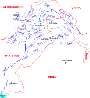
Location of the Nilam (Kishen Ganga) in the river system of the Indus |
||
| Data | ||
| location |
Jammu and Kashmir ( India ), Asad Kashmir ( Pakistan ) |
|
| River system | Indus | |
| Drain over | Jhelam → Chanab → Panjnad → Indus → Indian Ocean | |
| origin |
Krishansar Lake 34 ° 23 ′ 50 ″ N , 75 ° 6 ′ 10 ″ E |
|
| Source height | 3801 m | |
| muzzle | in Muzaffarabad in Jhelam Coordinates: 34 ° 21 ′ 18 " N , 73 ° 28 ′ 7" E 34 ° 21 ′ 18 " N , 73 ° 28 ′ 7" E |
|
| Mouth height | 750 m | |
| Height difference | 3051 m | |
| Bottom slope | 12 ‰ | |
| length | 245 km | |
| Drain |
MQ |
465 m³ / s |
| Medium-sized cities | Muzaffarabad | |
|
Nilam River with Habba Khatoon Mountain in the background |
||
|
Confluence of the Nilam (below) into the Jhelum (above) |
||
The Nilam ( English Neelum or Neelam ) is a right tributary of the Jhelam in the Indian union territory of Jammu and Kashmir and in the Pakistani semi-autonomous region of Asad Kashmir .
The Nilam has its origin in the 3801 m high Krishansar Lake in Jammu and Kashmir. In the upper reaches the river is called Kishen Ganga . It flows in a predominantly westerly direction through the western foothills of the Himalayas . The river runs along the so-called " Line of Control ", the demarcation line between Pakistan and India. After 50 km he reaches the semi-autonomous Pakistani region of Asad Kashmir . The Nilam finally flows into the Jhelam on the right in the city center of Muzaffarabad .
The Nilam has a length of 245 km. The mean discharge is 465 m³ / s.
Neelum Jhelum Hydroelectric Project (NJHEP)
An ecologically controversial hydropower project has been implemented on the lower reaches of the Nilam since 2013. It provides for a 60 m high and 160 m wide embankment dam near Nauseri, 41 km northeast of Muzaffarabad, to which up to 280 m³ / s of river water can be reached via a 19.54 km long double tunnel and a subsequent 8.94 km long tunnel a hydroelectric power station at Chatter Kalas on Jhelam. The upper course of the Jhelam is crossed by the tunnels, 180 m below its river bed.
Four Francis turbines with an output of 242.25 MW each are planned for the power plant . The hydraulic potential is 420 m. Below the power plant, a 3.54 km long tunnel leads the water to the Jhelam, 4 km south of Chatter Kalas and 22 km south of Muzaffarabad.
The completion of the project and the first test phase of the power generation are planned for the end of February 2018.
Web links
Individual evidence
- ^ Neelum Jhelum Hydroelectric Project - An Environment Disaster. Countercurrents.org, June 26, 2010 (accessed October 10, 2017).
- ↑ a b c d e f Neelum Jhelum Hydroelectric Project (NJHEP). ( Memento of the original from October 19, 2017 in the Internet Archive ) Info: The archive link was inserted automatically and has not yet been checked. Please check the original and archive link according to the instructions and then remove this notice. Pakistan Water and Power Development Authority (accessed October 10, 2017).


