Andaman Sea
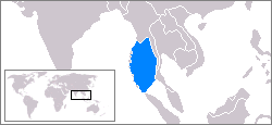
The Andaman Sea (including Andaman Sea , Andaman Sea , Hindi अंडमान सागर , burmese မုတ္တမ , Thai ทะเล อันดามัน , Indonesian and Malay According Andaman ) is a marginal sea of the eastern Indian Ocean , the coast of Myanmar , Thailand , Malaysia and the Indonesian island of Sumatra formed becomes. The Indian Union Territory of the Andaman and Nicobar Islands delimits the Andaman Sea in the west to the Bay of Bengal . To the south it is connected to the South China Sea by the Strait of Malacca .
Overall, the Andaman Sea stretches from the Irrawaddy River Delta (Irawady, Ayeyarwady) in the north for almost 1200 km to the entrance of the Strait of Malacca . Bounded in the west by the Cocos Islands , Andaman and Nicobar Islands , it is no more than 650 km wide. Its area is 797,700 km². The coast of Thailand alone is about 740 km long.
The measured maximum depth is 4180 m. The average depth is 870 meters. The water temperature at the surface varies slightly from 27.5 ° C in winter to 30 ° C in summer.
The Andaman Sea corresponds to a backarc basin that formed when the Indian plate hit the Eurasian plate . On the seabed of the Andaman Sea, a tectonic fracture zone extends in a north-south direction between the Burma plate in the west and the Sunda plate in the east. There are several islands of volcanic origin. Barren Island is the only one among them that has an active volcano.
On December 26, 2004, as a result of the Sumatran-Andaman quake, the islands and the coasts were devastated by a severe tsunami in which at least 230,000 people were killed.
Web links
Coordinates: 10 ° N , 96 ° E

