Bay of Bengal
| Bay of Bengal Baṅgopasāgar |
||
|---|---|---|
|
Fishing boat off St. Martin , an island in Bangladesh |
||
| Waters | Randmeer | |
| Geographical location | 15 ° 0 ′ 0 ″ N , 88 ° 0 ′ 0 ″ E | |
|
|
||
| surface | ≈ 2,200,000 km² | |
| Greatest water depth | 4694 m | |
| Medium water depth | 2600 m | |
| Islands | Sri Lanka and several archipelagos | |
| Tributaries | Ganges , Brahmaputra | |
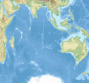
The Bay of Bengal ( Bengali বঙ্গোপসাগর baṅgopasāgar ; Indonesian Teluk Benggala ; Hindi बंगाल की खाड़ी Bangal Ki Khari ; malay Teluk Bengal ; Thai อ่าว เบงกอล ; rare German names: Bengal Gulf , Bengal Gulf , Bay of Bengal ) is a northeastern marginal sea of the Indian Ocean with an area of around 2,171,000 km². It is 2090 km long and up to 1610 km wide and has the shape of a triangle roughly. The gulf is an average of 2600 meters and a maximum of 4694 meters deep. It separates the land mass of the Indian subcontinent from the peninsula of rear India . The climate is characterized by the monsoons . Special features of the region are in particular a series of mud volcanoes and the largest mangrove forests on earth, such as the Sundarbans .
The Gulf of Bengal is bordered to the west by Sri Lanka and India , to the north by the eponymous region Bengal , consisting of the state of Bangladesh and the Indian state of West Bengal, and to the east by Myanmar , Thailand and Indonesia . In the south it is connected to the Indian Ocean. An imaginary line between the southern tip of Sri Lanka and the northern tip of the island of Sumatra , which belongs to Indonesia , can be assumed as an approximate delimitation of the gulf .
Islands
There are numerous archipelagos offshore, especially on the coasts, but without forming significant bays outside the estuaries . That is why there are few natural harbors on the coasts . In the eastern part of the island groups of separate Andaman and Nicobar Islands , the Andaman Sea from the sea bordering the Gulf. Great Andaman is the largest island of the Andaman Islands, with a group of smaller islands, the Ritchies Archipelago, in front of it to the east. The islands of Myanmar include the Mergui Archipelago and Cheduba . In the west, the Bay of Bengal borders the main island of Sri Lanka.
geology
The Gulf is in the area of higher tectonic plate activity . The Indian plate , part of the large Indo-Australian plate, moves slowly towards the northeast and slides under the Burmese microplate . The effects of this are volcanic eruptions and earthquakes. In the Gulf, the sediment loads from the Ganges and Brahmaputra form the Bengali deep-sea fan .
Ports
Chittagong and Mongla in Bangladesh, Chennai (Madras) and Kolkata (Calcutta) in India and Yangon (Rangoon) in Myanmar are the largest ports. Further Indian ports are located in:
- Kakinada in East Godavari District
- Pondicherry
- Visakhapatnam
- Odisha (Orissa)
Web links
Individual evidence
- ^ Gulf of Bengal - Zeno.org. In: zeno.org. Retrieved May 30, 2016 .
- ↑ Bengali Gulf - Lexicon. (No longer available online.) In: Wissen.woxikon.de. Archived from the original on May 30, 2016 ; accessed on May 30, 2016 . Info: The archive link was inserted automatically and has not yet been checked. Please check the original and archive link according to the instructions and then remove this notice.
- ↑ limited preview in the Google book search
- ↑ limited preview in the Google book search


