Earthquake off Sumatra in 2005
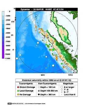
The Sumatran earthquake of March 2005 occurred on March 28, 2005 at 4:09:36 PM UTC (11:09:36 PM local time) off the coast of the island of Sumatra . The hypocenter was 2 ° 4 '35 " N , 97 ° 0' 58" E +/- 4 km, about 200 kilometers west of Sibolga on Sumatra (about 1400 km northwest of Djakarta ) in the Indian Ocean at a depth of 30 kilometers, about halfway between the islands of Nias and Simeulue . In this area, subduction forces the Indian plate along the Sunda Trench under the Burma and Eurasian plates .
The megathrust earthquake had a magnitude of M W = 8.6. The effects could still be felt in the Thai capital Bangkok, 1000 km away .
The earthquake killed around 1,300 people, mostly on the island of Nias. The event caused panic and fears of a tsunami in the region that was first hit by the 2004 Indian Ocean earthquake . Tsunami warnings have been triggered for numerous regions. However, there was only a three meter high tidal wave at Simeuluë , which did not cause much damage. However, the quake itself caused considerable damage on the islands off Sumatra, especially on Nias .
Strength of the earthquake and its consequences

The earthquake lasted about two minutes. In the twenty-four hours immediately after the earth tremors there were eight major aftershocks with a magnitude of M W = 5.5 and M W = 6.0. A debate arose among seismologists as to whether the earthquake should be assessed as an aftershock of the December 2004 event or whether it was a “triggered earthquake” , as it was considerably stronger than the usual aftershocks along the fault .
On the Indonesian island of Nias off the coast of Sumatra, hundreds of buildings were destroyed by the earthquake and at least a thousand residents were killed, 220 of them in Gunungsitoli , the island's largest city. About half of the city's 27,000 people fled.
The earthquake was clearly noticeable all over Sumatra and caused extensive power outages in Banda Aceh , which had already been badly damaged by the December 2004 tsunami. Many residents fled their homes and went to higher ground. The tremors were also felt on the west coast of Thailand and Malaysia. High-rise buildings have been evacuated in Kuala Lumpur . The earthquake in the Maldives , India and Sri Lanka was less noticeable .
Tsunami
The earthquake raised fears around the Indian Ocean of a tsunami similar to the catastrophic tsunami of December 26, 2004. Warnings of a tsunami had been issued by the Pacific Tsunami Warning Center operated by the United States' National Oceanic and Atmospheric Administration (NOAA) and the government of Thailand, as a large tsunami was feared, which would have moved south in particular from the hypocenter .
The south coast of Thailand, coastal areas in the northern states of Malaysia, Penang and Kedah , as well as the east coast of Sri Lanka have been evacuated. Ten people were killed in Sri Lanka because of the confusion during the evacuation. Alert was also announced for the southern coastal states of India . All of these areas were severely damaged by the December 26, 2004 tsunami. However, the earthquake caused relatively low tidal waves. A three meter high tsunami caused minor damage to the port and airport facilities on Simeuluë and a two meter high tidal wave was recorded on the west coast of Nias. Much lower tidal waves were measured around the Indian Ocean, most of them could only be detected by special tide measuring devices; for example in Colombo , Sri Lanka, 25 cm was measured.
The tidal wave reached the Cocos Islands belonging to Australia at a height of 30 cm, whereupon the island states Mauritius , Madagascar and the Seychelles warned their respective populations.
Humanitarian Responses
Australia sent medical personnel and equipment to Nias. The Australian warship HMAS Kanimbla , which had only recently been withdrawn from the Aceh region, was sent back to the region from Singapore. On April 2, 2005, one of the two Sea King helicopters belonging to the Kanimbla with the callsign "Shark 02" crashed on the island of Nias while transporting medical personnel. Nine people were killed on board.
See also
Web links
- Special Event Page, Amateur Seismic Center, India
- Royal Australian Navy assistance to earthquake relief
- United States Geological Survey event page
- Lethal quake rattles tsunami zone - BBC News
- Seismograms for this earthquake via REV, the Rapid Earthquake Viewer
- Earthquake causes coral reefs to die - CTV News
Individual evidence
- ↑ United States Geological Survey eventsPage ( English ) United States Geological Survey . March 28, 2005. Archived from the original on January 31, 2010. Info: The archive link was automatically inserted and not yet checked. Please check the original and archive link according to the instructions and then remove this notice. Retrieved January 16, 2010.
- ^ Southern Thailand evacuated after Indonesian earthquake (English) , Xinhua . March 28, 2005. Retrieved November 1, 2010.
