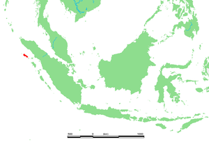
Simeuluë
| Simeuluë | |
|---|---|
| Topographic map | |
| Waters | Indian Ocean |
| Geographical location | 2 ° 35 ' N , 96 ° 5' E |
| surface | 2 310 km² |
| Highest elevation | (unnamed) 485 m |
| Residents | 82,100 (2007) 36 inhabitants / km² |
| main place | Sinabang |
Simeuluë is an Indonesian island off the west coast of Sumatra . It is 150 kilometers off the west coast of Sumatra in the Malay Archipelago in the Indian Ocean .
geography
The island is 2,310 square kilometers, twice the size of Ruegen . The capital is Sinabang in the southeast of the island. Simeuluë is located 60 km northwest of the Banyak Islands and 140 km northwest of Nias .
population
Most of the 82,000 residents are Muslim . Most of them live from agriculture and fishing . The most important products are cloves and coconuts .
language
The Sikule language is part of the northwest Sumatra branch of the Malayo-Polynesian languages .
nature
Simeuluë is considered a natural paradise. The island has developed a unique flora and fauna. In the north there are mangrove forests , the interior is forested. Coral reefs and numerous small islands can be found along the coast . The Simeulue scops owl is one of the endemic animal species. Simeuluë is off the beaten track of mass tourism. Only a few surfers have found their way there so far.
Natural disasters
Simeuluë is only a few kilometers from the epicenter of the seaquake on December 26, 2004 . There was enormous property damage at the time, but only a few deaths. People fled to the mountains in good time because they had been warned by stories: when Simeulue was hit by a severe tsunami in 1907 , thousands died. Even then, the sea had initially withdrawn. As a result of the shifting of the tectonic plates that led to the earthquake, the island was relocated: It is now about 15 meters further south-west than before the quake.
Much of the island was destroyed by a major fire after the three meter high tidal waves in the course of the severe seaquake with the epicenter of Nias on March 28, 2005 . The adjacent banyak islands were also badly hit.
- Views


