Karimunjawa Islands
| Karimunjawa Islands | ||
|---|---|---|
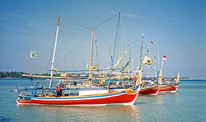
| The port in 1997 | ||
| Waters | Java lake | |
| archipelago | Great Sunda Islands | |
| Geographical location | 5 ° 47 ′ S , 110 ° 21 ′ E | |
|
|
||
| Number of islands | 27 | |
| Main island | Karimunjawa | |
| Total land area | 78 km² | |
| Residents | 9054 (2008) | |
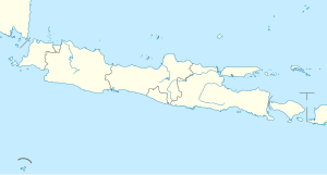
The Karimunjawa Islands (also Karimunjava Islands , Indonesian Kepulauan Karimunjawa ) are a group of islands that belongs to Indonesia . The group's 27 islands are located in the Java Sea , around 80 kilometers off the north coast of Java Island .
The Karimunjawa Islands have been a nature reserve since 1986. The Indonesian Ministry of Forestry created the Karimunjawa National Park in 1999 , which is spread over an area of 110,625 hectares in tropical rainforest , mangroves and sea areas. In 2001, 110,117 hectares were declared one of six marine protected areas in Indonesia.
geography
Geologically, the Karimunjawa Islands belong to the land mass of the Sundaland . In the Neogene era , the main island of Karimunjawa was the highest peak in the region. During the Gelasia , the islands were separated from the mainland.
The landmass consists mainly of quartz-bearing sandstone , gravel , clay minerals, and muddy soils. There are also sections that are covered with sandy beaches.
The mountainous main island of Karimunjawa has a land area of 46.2 square kilometers. There is also the mountain Gendero , with about 464 m the largest elevation in the area. The main island is connected to the 15 square kilometer neighboring island of Kemujan via a mangrove forest. The next larger island is Parang with 8.7 square kilometers.
Islands
Inhabited islands
|
Uninhabited islands
|
Flora and fauna

The ecosystem consists of a rich flora and fauna. There are areas with coral reefs , seagrass meadows , mangrove forests, forests near the coast and slightly higher areas with tropical rainforest. Three islands are the habitat of Macaca fascicularis karimondjiwae , a subspecies of the widespread in Southeast Asia cynomolgus monkeys . Their number was estimated to be less than 500 in 2008. Also suitable mane deer , Malayan pangolins or Malay Mokassinottern ago.
There are 40 different species of birds on the islands. There are breeding grounds for the white-bellied sea eagle on the two islands of Burung and Gelean . Other bird species are, for example, the pink-headed fruit pigeon , the bronze fruit pigeon and subspecies of the yellow-bellied bulbul ( Pycnonotus goiavier var. Karimudjawae ) and the bearded parakeet ( Psittacula alexandri var. Karimundjawae ). Migratory birds such as the common sandpiper or the whimbrel have been observed, but also butterflies such as Idea leuconoe karimondjawae , a subspecies of the white tree nymph .
There are several fringing reefs and barrier reefs , as well as some shipwrecks in the water. There are 16 protected animal species, for example the green turtle and the hawksbill sea turtle , various types of giant clams such as the burrowing giant clam, hippopus hippopus , the ingrown giant clam, the scaly giant clam and the smooth giant clam. In addition to Nautilus pompilius , one of only six existing species of pearl boats , the helmets horned helmets , the conch and turbo marmoratus are also protected. A total of more than 90 species of coral from 51 genera , including the rare organ coral or black coral , and 242 different species of reef fish were counted.
The seagrass areas are dominated by Thalassia and Enhalus . A total of 10 different genera were counted. There are different seaweed plants in the water, such as Caulerpa or Halimeda , which belong to the green algae , various brown algae such as golf rod , Padina or Turbinaria reniformis and the red algae Gracillaria , Gelidium , Hypnea or Acanthophora . Mangroves, such as Rhizophora mucronata , cover an area of about 400 hectares. There are 13 genera with 32 different species. Various plant species live on the coastal areas, such as the linden-leaved marshmallow , Streblus asper from the mulberry family , the horsetail- leaved casuarina or the catapult tree . Parts of the island are covered with tropical lowland rainforest , there are various endemic species such as Fagraea elliptica , Cordia subcordata or Pemphis acidula , which belongs to the loosestrife family .
climate
The climate is characterized by the monsoon , which comes from the northwest and then brings an average of about 40 millimeters of rain per day. When it comes from the southeast between April and October, dry warm winds blow from the east to the southeast. The ocean current then moves masses of water from the direction of Lake Flores to the west.
administration
The Karimunjawa Islands form a separate sub-district ( Kecamatan ) in the Jepara administrative district, which is located in the Central Java Province . This is divided into the three communities ( Kelurahan ) Karimunjawa, Kemojan and Parang, which represent the lowest administrative level.
history
The name and discovery date back to a time when Islam was spreading in Indonesia . Legend has it that Sunan Nyamplungan or Amir Hasan , who is also said to be buried there, traveled to the islands. His father, Sunan Muria , one of the "nine confidants (of God)," also known as Wali Songo , had previously sent him away. From the Muria volcano on the north coast of Java, Sunan Muria could not see the islands on the horizon clearly or blurred , which means kremun-kremun soko jowo in Javanese . The name Karimunjawa developed from this.
During the colonial period, some explorers traveled to the Karimun Islands, for example the Dutchman Johannes Elias Teijsmann in 1854 or Rudolf Schlechter in 1910.
population
The population is made up of Javanese , Maduresen , Bugis , Mandar , Luwu and Bajak . Five islands are inhabited. Most of the 9054 inhabitants (as of 2008) live in the only small town Karimunjawa on the southwest tip of the main island. Other inhabited islands are Kemujan, Nyamuk, Parang and Genting.
economy
At 45.4 percent, a little less than half of the population lives from fishing . Another 18.5 percent are engaged in the cultivation of food (as of 2008).
Several thousand tourists visit the Karimunjawa National Park every year , many of them wealthy Indonesians and foreign divers . Most of the hotels are located on the main island of Karimunjawa. There is a diving instructor in the village of Karimunjawa who runs the Djawa Dive base . On the private island of Menyawakan there is an upper class resort with CMAS diving bais.
traffic
There is an airport on the island of Kemujan with a connection to the provincial capital Semarang . The port is located on the main island of Karimunjawa. There is a ferry to Jepara and a speedboat to Semarang. There are around 22 kilometers of roads. One leads around the mountainous island of Karimunjawa to Kemujan. The use of a buoy is a common variant in local transport .
Web links
- More information about the Karimunjawa Islands
- More information, photos & travel report about the Karimunjawa Islands
- Information about travel, accommodation, etc. in German
Individual evidence
- ↑ a b c d e f g Karimunjawa - Marine National Park Central Java, Indonesia - "The Oasis of Java". (PDF; 162 kB) (No longer available online.) ASEAN Regional Center for Biodiversity Conservation ( ARCBC ), Los Baños , Philippines, 2003, archived from the original on June 6, 2011 ; accessed on June 17, 2011 (English, only 22 instead of 27 islands are mentioned here). Info: The archive link was inserted automatically and has not yet been checked. Please check the original and archive link according to the instructions and then remove this notice.
- ↑ Tomas Tomascik: The Ecology of the Indonesian Seas: Part 2 . Periplus Editions, 1957, ISBN 978-962-593-163-0 , pp. 686 (English).
- ↑ georeferencing 5/50 / 43.05 / S110 / 27 / 18.59 / E .
- ↑ a b c d Agustín Fuentes: Monkeys on the Edge . Ecology and Management of Long-Tailed Macaques and their Interface with Humans. In: Cambridge Studies in Biological and Evolutionary Anthropology . Cambridge University Press, Cambridge 2011, ISBN 978-0-521-76433-9 , pp. 12 (English).
- ↑ a b c d e Karimunjawa National Park. (No longer available online.) Kementerian Kehutanan Republic of Indonesia (Indonesian Ministry of Forestry), archived from the original on April 4, 2010 ; accessed on June 17, 2011 (English). Info: The archive link was inserted automatically and has not yet been checked. Please check the original and archive link according to the instructions and then remove this notice.
- ↑ Diving Karimunjawa Islands. Menyawakan Island. (No longer available online.) Indonesiadiving.com, archived from the original on March 7, 2009 ; accessed on June 18, 2011 (English). Info: The archive link was inserted automatically and has not yet been checked. Please check the original and archive link according to the instructions and then remove this notice.
- ^ A b c Ryan Ver Berkmoes: Indonesia . 9th edition. Lonely Planet, 2010, ISBN 978-1-74104-830-8 , pp. 218-220 (English).
- ↑ Statistics Kehutanan Indonesia 2007. (PDF; 5.4 MB) Kementerian Kehutanan Republic of Indonesia (Indonesian Ministry of Forestry), 2008, accessed on June 18, 2011 (Indonesian, English).


