Togian Islands
| Togian Islands | ||
|---|---|---|
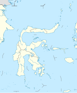
| Location of the Togian Islands | ||
| Waters | Gulf of Tomini | |
| Geographical location | 0 ° 25 ′ S , 121 ° 52 ′ E | |
|
|
||
| Number of islands | 56 | |
| Main island | Wakai | |
| Total land area | 700 km² | |
| Residents | 40,000 | |
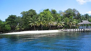
| The island of Taipih (almost 400 m lengthwise diameter), 1.5 km in front of the island of Kadidiri | ||
The Togian Islands ( Indonesian Pulau Togian ) are an archipelago of 56 islands in the deep incision of the Gulf of Tomini between the northern and eastern mainland arms of Sulawesi , Indonesia . They form a 120 km long, highly fragmented island arc. A total of around 40,000 people live in 37 villages on the various islands. The capital is Wakai. It is only 24 nautical miles south of the equator at 00 ° 25 'South, 121 ° 52' East. Other larger settlements are Katupat, Malengeh and Dolong. The population consists of various ethnic groups , the Bobongko, Togiani, Suluan, Bajau and the Bajau samari- sea nomads .
traffic
Wakai is connected to Ampana in the south and Gorontalo in the north by a ferry service operated three times a week . In addition, there is a ferry from Ampana several times a week, which also goes to the other major locations. Traffic between the islands is handled by local boats.
environmental Protection
The Togian Islands were declared a national park in October 2004 . The park encompasses all of the Togian Islands and the waters in which they are located. At the same time, the islands were subordinated to the Kabupaten Ampana district. Before that, the cyanide and dynamite fisheries had caused severe damage to the corals in areas. Today one tries to remedy this as much as possible and to protect the reefs.
tourism
The species-rich underwater world in particular attracts tourists to the Togian Islands, who snorkel or dive in the coral reefs . In the largely untouched interior of most of the islands, sea eagles , brahmin harriers , hornbills , black cormorants and parrots can be observed. There are also the palm- sized coconut crabs or palm thieves and the tarsier Tarsius niemitzi . On several islands, for example on Kadidiri, there are small holiday resorts , which are often connected to a diving center. With one exception, they belong to the lower to middle category. Since the islands are difficult to reach, the number of visitors is limited.
Diving area
The diving area around the Togian Islands includes around 30 different dive sites. Most of them offer good visibility (20–40 m) with little current and water temperatures of 27 to 30 ° C. As a special feature - in addition to over 1500 fish and 4000 mollusc species - large schools of barracuda encompassing thousands of animals can be seen.
There are diving centers on four of the islands (Bomba, Kadidiri, Katupat and Una Una ). Day tours from Ampana or Gorontalo to the islands are not possible due to the great distances. Diving courses in German are offered in Bomba (Bomba Divers).
economy
With a 90 percent share, the largest source of income is seafood . In addition, rice and coconut palms grown, also nutmeg , cocoa and cloves . Just outside there are larger pearl farms in some sheltered bays.
Second World War
In May 1945, the joint armed forces of Australia and the United States aimed to regain control of important oil fields by invading the island of Tarakan off the northeast coast of Borneo . The Air Force had been tasked with destroying Japanese runways and bases on Borneo and Sulawesi since the end of April .
"Friday, early afternoon, May 3, 1945. An unusually nameless B-24 Liberty bomber of the US 307th Bomb Squadron bursts an hour and a half before the target over Bone Bay (between the two southern mainland arms of Sulawesi) in the first engine on the right Fire out. The pilot Lt. Etheridge cuts off the fuel supply, but neither the automatic extinguishing system nor the airflow bring the situation under control. After hasty calculations, there is no fuel for a return to the base with only three engines and increased power. Dense vegetation, heavily rugged terrain and other variables only allow risky watering in the Gulf of Tomini near the Togian Islands. Radio operator Lt. Chamberlain contacts the ground station in Moratai and informs them of the imminent emergency landing, while the crew is about to throw bombs and all ammunition including two on-board machine guns, all windows and objects overboard that could endanger crew members in the event of an impact. Only essential equipment is withheld. It's too rough on the north side of the Togian Islands today, so a landing site is identified on the south side and flown over twice at 2,000 feet. All crew members wear winter equipment to mitigate the force of the impact and have secured each other according to emergency instructions. In the later protocol u. a. detailed: "The machinist was sitting between the legs of the bow and stern gunner, face aft." Up to five feet above water, the speed is 115 mph , then the engine output is reduced. "
- A long alarm tone warns the crew for the last time, then the machine touches down at 95 mph. The landing succeeds, the plane rushes about 50 yards above the surface of the water before it comes to a standstill. In a minute, everyone outside the bomber was safely in two rubber dinghies. Nobody suspects that the bomber will drift on the surface for another 1½ hours. There were no serious injuries apart from a few wounds. After the injured have been taken care of, all 6 one-man life jackets, jungle kits, blood plasma and first aid kits are rescued from the wreck. Finally it says in the report: "All secret and cryptographic material was destroyed and sank in a weighted bag to a depth of probably 40 feet." Before sinking, the crew is picked up by a large watering Catalina rescue plane .
Today the B 24 lies flat on the ground a few hundred meters from the coast at a depth of 17 to 24 m, unmarked. The fuselage is oriented northwest, the whole machine is still in good condition. The wreck is a popular destination for divers .
Web links
- TravelTwins.dk page with many pictures of the Togian Islands (English)
- Detailed report with pictures by the translator and freelance travel journalist Klaus Polak
- Report and practical tips on the island of Kadidiri from travel journalist Oliver Zwahlen
- Detailed information and tips for a trip to the Togian Islands
Individual evidence
- ↑ The Togeans, dive-the-world.com, accessed on August 12, 2015.
- ↑ Roland Dusik: Travel Guide Indonesia. Mair Dumont, 2015, pp. 524-525, ISBN 978-3-7701-7745-5 .
- ^ Moritz Jacobi, Mischa Loose, Christian Wachsmuth: Indonesia from Sumatra to Sulawesi . Lonely Planet, 2012, p. 75, ISBN 978-3-7701-6703-6 .


