Gulf of Tomini
| Gulf of Tomini | ||
|---|---|---|
|
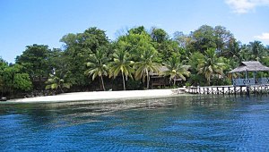
The small island of Taipih of the Togian Islands in the Gulf of Tomini |
||
| Waters | Moluccan Sea | |
| Land mass | Sulawesi | |
| Geographical location | 0 ° 0 ′ S , 121 ° 0 ′ E | |
|
|
||
| width | 217.4 km | |
| depth | 380 km | |
| surface | 56,000 km² | |
| Greatest water depth | 4180 m | |
| Islands | Togian Islands | |
| Tributaries | Poso , Sungai Bongka | |
The Gulf of Tomini ( Indonesian Teluk Tomini ) is a bay in the west of the Moluccan Sea , which is embedded between the Minahassa Peninsula in the north and the Semenanjung Timur peninsula (eastern arm of the Indonesian island of Sulawesi ) in the south. The narrowest part of the gulf, only 95 kilometers wide, is located between Tanjung Tambalilatu on the south coast of the Minahassa Peninsula and the Bualemo Peninsula off the eastern arm . Further west, the gulf expands to about 200 kilometers.
The Tomini Basin to the west, with a water depth of a little more than 1500 meters, and the Gorontalo Basin to the east , which is a little more than 4000 meters deep, belong to the Gulf of Tomini . The Togian Islands and the Una Una Island separate the Tomini from the Gorontalo Basin . In the Gulf of Tomini there are different types of coral reefs that are among those with the greatest biodiversity in Indonesia.
Individual evidence
- ↑ a b Tomas Tomascik: The Ecology of the Indonesian Seas. Part 2, page 746f, Oxford University Press, Oxford 1997, ISBN 0-19-850186-2
- ↑ D. Kusnida, Subarsyah: Deep Sea Sediment Gravity Flow Deposits in Gulf of Tomini, Sulawesi. Indonesian Journal of Geology, 3:, 217–224, 2008 ( online )


