
Saressee
| Saressee | |||||||||
|---|---|---|---|---|---|---|---|---|---|
 |
|||||||||
|
|||||||||
|
|||||||||
| Coordinates | 38 ° 12 '6 " N , 72 ° 45' 27" E | ||||||||
| Data on the structure | |||||||||
| Height above valley floor: | Max. 550 m | ||||||||
| Height of the structure crown: | 3263 m | ||||||||
| Building volume: | 2–2.2 km³ | ||||||||
| Crown length: | 4.5 km | ||||||||
| Base width: | approx. 4 km | ||||||||
| Data on the reservoir | |||||||||
| Water surface | ~ 80 km² | ||||||||
| Reservoir length | 55.8 km | ||||||||
| Reservoir width | Max. 3.3 km | ||||||||
| Total storage space : | 16.074 km³ | ||||||||
| on 18 February 1911 by an earthquake and landslide created | |||||||||

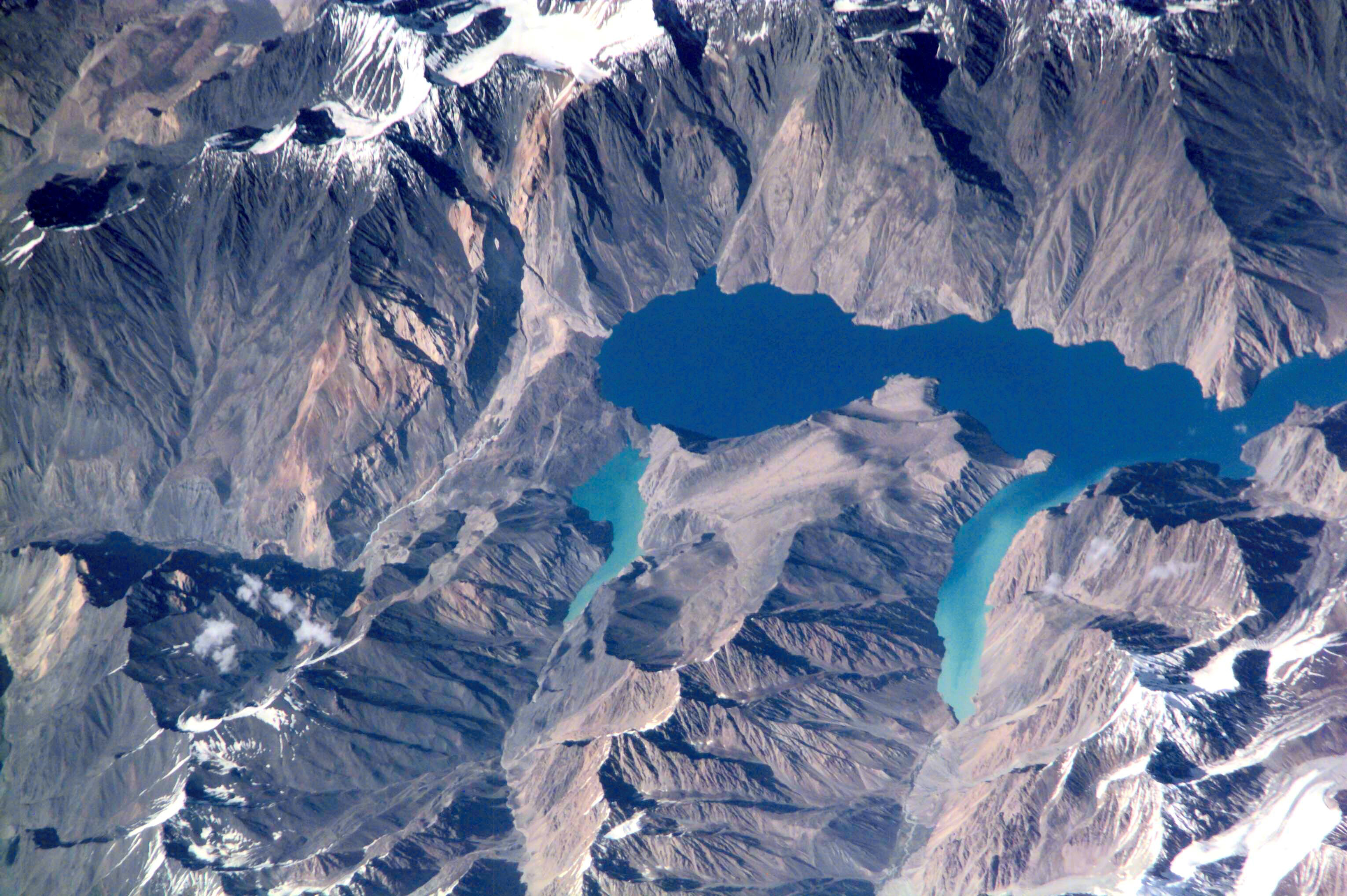
The Saressee ( Tajik кӯли Сарез Köli Sarez ) is a lake in eastern Tajikistan ( Central Asia ).
geography
The mostly deep blue lake is located in the Berg-Badachschan area in the Pamir Mountains , about 75 km (as the crow flies ) west of the city of Murgab . The river Murgab flows through it.
history
The Saressee was created on February 18, 1911 by a massive landslide , triggered by an earthquake with a presumed magnitude of 8 to 9 on the Richter scale . He completely sealed off the deeply cut valley of the Murgab River with around 2 to 2.2 km³ of earth and rock material and buried the village of Usoi under himself.
This landslide also created the Shadausee , another small lake, which, a little off the Saressee, points at right angles to the southwest.
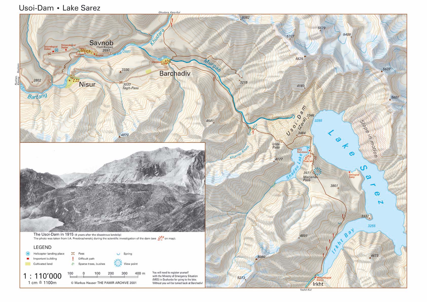
The left by the landslide and named after the village buried Usoi - Dam (also Usoj- or Usojskij-spillage or -Versperrung called) is significant at the crown 5 km long and at the base of a maximum of 3.2 km wide. At the highest point of its dam crest, it is about 567 m high. This makes it the highest naturally created dam on earth and significantly exceeds the height of the highest artificially created dam, the Nurek Dam .
In the years after the dam emergence of the river Murgab formed a kilometer-long 55.8, a maximum of 3.3 km wide and up to 500 m deep natural lake, the maximum 16.074 km ³ contains water, which is more than five times the volume of Lake Starnberg is. The water level of the Saressee is more than 38 m below the lowest point of the dam crest. The Saressee (like the Shadausee ) has no open drain; its water seeps through the dam and emerges on its valley side about a hundred meters deeper in a "spring" as a mountain river with a volume flow of 35 to 70 m³ / s.
The Sarez Lake is lined with many mountains or mountain chains, which at present, the full back in 3263 m , lying level water surface, which was quantified square kilometers when measured in 1987 to 79.6 by at least 2416 m protrude height. For example, immediately north of the dam is a 5679 m high, glaciated mountain, which is preceded by two 5525 m and 5273 m high mountains to the south , whose directly adjacent mountain flanks were the site of the landslide of 1911. Due to the mostly very steeply sloping and at the same time bare mountain slopes, the lake has hardly any developed bank areas, so that it is not accessible to traffic or only through paths and paths that lead to the dam, for example.
The Saressee or Usoi dam is one of several, smaller and larger lakes and collapse barriers that were caused by earthquakes in Tajikistan and the Pamirs.
Source of danger
Geologists fear the potentially unstable Usoi Dam could break during another powerful earthquake, leading to a devastating disaster:
When the dam actually would break, the waters of the would Saressees over the Murghab, Bartang , the Panj and Amu Darya towards the Aral Sea spill, not just the shorelines of this river course in Tajikistan, Afghanistan , Uzbekistan and Turkmenistan flood. This would affect around 5 million people as well as the flora and fauna in the entire region. According to research, an initially 150 to 170 m high tidal wave would pour into the valley, which at Amu Darya could be the height of a two-story house.
In addition, the water flowing out of the lake itself represents a potential source of danger: the lake water does not run over the dam crest, but seeps into the lake-side embankment. It is feared that the filtration water will wash out ever larger cavities, which would gradually cause the Usoi dam to lose its stability. On the embankment on the valley or air side, the water emerges as a mountain river far below the dam crest; Below this “source”, the Murgab forms an ever-increasing gorge in the area of the dam, so that the dam is gradually eroded. Furthermore, because the glaciers of the Pamir are increasingly melting due to global warming , the water level has risen from 3239 m to 3263 m above sea level in recent years , an increase of almost 25 m, which increases the water pressure on the dam and the lake area grew to just over 80 km². In the winter months, when the glaciers freeze again, the water level drops by up to 12 m and then rises again.
Much greater than the risk of a dam breaking is a foreseeable collapse or slipping of a rock face opposite the dam around 4 km away, on which a 1.5 km long crevice has formed. Even with a slight earthquake, this wall could fall into the lake, whereby about 0.5 to 1 km³ of rock would slide into the Saressee . The tidal wave created by the displacement of the water would drive the water masses against the banks and possibly over the dam. In the worst case, this would lead to the partial or total collapse of the dam, which would lead to a disaster in the valleys below the dam.
Due to all these sources of danger, an earthquake monitoring system was installed at the Usoi Dam in 2004 . At the same time, sirens were installed in the villages downstream in the Murgab and Bartang valleys, which are powered by solar and battery power so that, ideally, they are ready for use around the clock.
Web links
- Map of the Berg Badakhshan region in Tajikistan
- Satellite image of the lake
- Map 1: 110 000 of the Usoidamm dam with Lake Saressee
- Lake Sarez in Asian Disaster Reduction Center, Country Report 2003 Tajikistan
- Tajikistan: Lake Sarez and the Pamir Mountains on FAO.org (PDF; 71 KB)
- Patrice Droz, Ljiljana Spacic-Gril: Lake Sarez Risk Mitigation Project - A Global Risk Analysis Report for the IAHR Symposium in St. Petersburg 2002 (English)
- Patrice Droz, Ljiljana Spacic-Gril: Lake Sarez Risk Mitigation Project: A Global Risk Analysis Report for the Conference on Large Dams in Barcelona 2006 (English)
literature
- Richard Stone: The Blue Peril. Unstable reservoir in Asia threatens five million people. Süddeutsche Zeitung No. 293, 19./20. December 2009, p. 22 ("Knowledge" section)
Individual evidence
- ↑ cf. the Russian information on cadrr.net: САРЕЗСКОЕ ОЗЕРО ( memento of the original from April 19, 2015 in the Internet Archive ) Info: The archive link was inserted automatically and has not yet been checked. Please check the original and archive link according to the instructions and then remove this notice. Website with academic articles on earthquakes, here with all information about Lake Saress