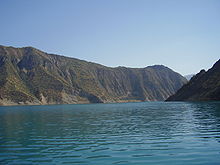
Nurek Dam
| Nurek Dam | |||
|---|---|---|---|
|
|||
|
|
|||
| Coordinates | 38 ° 22 ′ 12 ″ N , 69 ° 21 ′ 0 ″ E | ||
| Data on the structure | |||
| Construction time: | 1961-1980 | ||
| Height of the barrier structure : | 300 m | ||
| Height above foundation level : | 316 m | ||
| Building volume: | 54 or 58 million m³ | ||
| Crown length: | 704 m | ||
| Base width: | 1180 m | ||
| Power plant output: | 3000 MW | ||
| Data on the reservoir | |||
| Water surface | 98 or 106 km² | ||
| Storage space | 10,500 million m³ | ||
| Design flood : | 4000 m³ / s | ||
The Nurek Dam in Tajikistan in Central Asia is 300 m high, together with Jinping I, is currently the highest dam in the world and could become the second highest once the Rogun Dam is completed, if it is built as high as originally planned.
dam
The Nurek- dam on the outskirts of Norak dammed the river Vakhsh , a source river of Amu Darya , about 50 km east of the Tajik capital Dushanbe below the under construction Rogun dam. It was built between 1961 and 1980. The dam has a 704 m long stone embankment with a core seal and a structure volume of 54 million m³ (according to other sources 58 million m³). The dam is sealed with an inner core made of clay, which extends 16 m below the river bed. The area is very prone to earthquakes, which is why an embankment was chosen and no concrete was used.
Reservoir
The reservoir of the reservoir is 10.5 billion m³, the water surface 98 km². The hydroelectric power plant built together with the dam had an installed capacity of 2.7 GW in the first expansion stage with nine turbines , and 3 GW after a later conversion. This power is sufficient to supply almost all of Tajikistan with electrical energy.
The reservoir is also used to irrigate 650,000 hectares of agricultural land.
See also
- List of power plants in Tajikistan
- List of dams in the world (Tajikistan)
- List of the largest reservoirs on earth
- List of the largest dams on earth
- List of the largest hydroelectric plants in the world
Web links
- History of Nurek Dams
- World's Highest Dams
- World's Highest Dams, 2000
- Megadams: Pros, Cons, and Consequences
- The Nurek and Rogun dams on the Vachsch (PDF; 718 kB)


