
Autonomous circle of the Khanty and Mansi / Ugra
|
Subject of the Russian Federation
Khanty and Mansi Autonomous Okrug / Ugra
Ханты-Мансийский автономный округ - Югра Хӑнты-Мансийской автономной округ - Югра
|
||||||||||||||||||||||||||||||||||||
  |


Coordinates: 62 ° 0 ′ N , 72 ° 30 ′ E
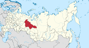
The Autonomous District of Khanty-Mansi , also known as Yugra designated ( Russian Ханты-Мансийский автономный округ - Югра / Khanty-Mansijski awtonomny okrug - Yugra , Khanty Хӑнты-Мансийской автономной округ - Югра ) is an administrative unit ( Autonomous District ) in Russia .
geography
The autonomous district is located east of the Ural Mountains in the West Siberian lowlands . The Ob and its most important tributary, the Irtysh , flow through the region.
population
The Khanty and Mansi , Finno-Ugric peoples who are the closest relatives of the Magyars , are the titular nations . However, they only make up a fraction of the population, most of the inhabitants are Russians . This trend has been intensified by the discovery and exploitation of the oil fields. The last Russian census in 2010 recorded 1,532,243 residents. More than 60% of them were Russians. The Ukrainians and Tatars also have high minority shares . The Bashkirs , Chuvashes and Komi come from other autonomous regions. Since 1970, there have also been numerous Azerbaijanis (1970: 136; 2010: 26,037 people), Belarusians (1970: 3,362; 2010: 14,703 people), Kumyks (1970: 5; 2010: 13,849 people), Lesgians (1970: 44; 2010: 13,335 People), Uzbeks (1970: 57; 2010: 9,970 people), Tajiks (1970: 23; 2010: 9,793 people), Moldovans (1970: 579; 2010: 9,476 people), Chechens (1970: 68; 2010: 6,889 people) and Armenians (1970: 147; 2010: 6,343 people) immigrated. In addition, Germans from Russia also live in the area.
| Ethnic group | VZ 1939 | VZ 1959 | VZ 1970 | VZ 1979 | VZ 1989 | VZ 2002 | VZ 2010 1 | |||||||||
|---|---|---|---|---|---|---|---|---|---|---|---|---|---|---|---|---|
| number | % | number | % | number | % | number | % | number | % | number | % | number | % | |||
| Chanting | 12,238 | 13.1% | 11,435 | 9.2% | 12,222 | 4.5% | 11,219 | 2.0% | 11,827 | 0.9% | 17,128 | 1.2% | 19,068 | 1.2% | ||
| Mansen | 5,768 | 6.2% | 5,644 | 4.6% | 6,684 | 2.5% | 6.156 | 1.1% | 6,562 | 0.5% | 9,894 | 0.7% | 10,977 | 0.7% | ||
| Russians | 67,616 | 72.5% | 89,813 | 72.5% | 208,500 | 76.9% | 423,792 | 74.3% | 850.297 | 66.3% | 946,590 | 66.1% | 973.978 | 63.6% | ||
| Tatars | 2,227 | 2.4% | 2,938 | 2.4% | 14,046 | 5.2% | 36,898 | 6.5% | 97,689 | 7.6% | 107,637 | 7.5% | 108,899 | 7.1% | ||
| Ukrainians | 1,111 | 1.2% | 4,363 | 3.5% | 9,986 | 3.7% | 45,484 | 8.0% | 148.317 | 11.6% | 123.238 | 8.6% | 91,323 | 6.0% | ||
| Bashkirs | 9 | 0.0% | 91 | 0.1% | 1,244 | 0.5% | 7,522 | 1.3% | 31,151 | 2.4% | 35,807 | 2.5% | 35,428 | 2.3% | ||
| Belarusians | 141 | 0.2% | 1,281 | 1.0% | 3,362 | 1.2% | 7,555 | 1.3% | 27,775 | 2.2% | 20,518 | 1.4% | 14,703 | 1.0% | ||
| Tschuwaschen | 45 | 0.0% | 289 | 0.2% | 1.929 | 0.7% | 4,739 | 0.8% | 13,959 | 1.1% | 15,261 | 1.1% | 13,596 | 0.9% | ||
| Mari | 34 | 0.0% | 54 | 0.0% | 712 | 0.3% | 1,791 | 0.3% | 5,801 | 0.5% | 7,309 | 0.5% | 7,289 | 0.5% | ||
| German | 177 | 0.2% | 2,059 | 1.7% | 2,069 | 0.8% | 3,499 | 0.6% | 8,929 | 0.7% | 8,292 | 0.6% | 6,828 | 0.4% | ||
| Komi | 2,436 | 2.6% | 2,803 | 2.3% | 3,150 | 1.2% | 3,105 | 0.5% | 3,000 | 0.2% | 3,081 | 0.2% | 2,364 | 0.15% | ||
| Nenets | 852 | 0.9% | 815 | 0.7% | 940 | 0.3% | 1.003 | 0.18% | 1,144 | 0.09% | 1,290 | 0.09% | 1,438 | 0.09% | ||
| Other | 620 | 0.7% | 2,341 | 1.9% | 6.313 | 2.3% | 18,000 | 3.2% | 75,945 | 5.9% | 136,772 | 9.5% | 246.352 | 16.1% | ||
| Residents | 93,274 | 100% | 123.926 | 100% | 271.157 | 100% | 570.763 | 100% | 1,282,396 | 100% | 1,432,817 | 100% | 1,532,243 | 100% | ||
| 1 102,138 people could not be assigned to any ethnic group. These people are probably distributed in the same proportion as the ethnically classified inhabitants. | ||||||||||||||||
history
The area originally known as Jugorien or Ugra was visited by merchants from Novgorod in the 12th and 13th centuries . In 1582 it was conquered by Yermak and came under Russian rule. On December 10, 1930 , the East Yak-Vogul National District (Остя́ко-Вогу́льский национа́льный о́круг) was founded, which was renamed the National District of Khanty and Mansi in October 1940. The area received the status or name "Autonomous Circle" ( Okrug , also translated as "District") in 1977 at the same time as other previously "National Circles" (districts) of the RSFSR .
In 2003 the official name of the subject of the federation was supplemented by the word "Ugra".
economy
The oil - and natural gas is by far the most important industry. The Khanty and Mansi Autonomous Okrug is the largest oil producer in Russia and has the highest regional GDP per capita of any federal entity . With over 1.1 million rubles per capita and year (2007), according to this parameter, it is roughly at the level of Germany .
The traditional industries of the indigenous people are reindeer herding , hunting and fishing . These are badly affected by the effects of oil and gas production, as the gas and oil industries take over large territories and destroy or cut up grazing areas on a large scale. Almost 70 percent of the oil disasters in Russia are recorded in the autonomous districts of Khanty-Mansiysk and Yamal-Nenets, where around 60 percent of Russian oil is extracted (see also: Oil spill in Western Siberia ) .
politics
Natalia Komarowa has been the governor of the Autonomous Okrug since 2010, replacing Alexander Filipenko in this position . The Duma of the Khanty and Mansi / Ugra Autonomous Okrug is the unicameral parliament .
Administrative division
The autonomous district of the Khanty and Mansi / Ugra is divided into 9 Rajons and 13 urban districts .
Cities
The administrative center of the Autonomous Okrug is Khanty-Mansiysk . The biggest cities are Surgut , Nizhnevartovsk and Nefteyugansk . In total there are 16 cities and 24 urban-type settlements in the Autonomous Okrug . All larger cities form urban districts.
| Surname | Russian | Residents (October 14, 2010) |
|---|---|---|
| Surgut | Сургут | 306.675 |
| Nizhnevartovsk | Нижневартовск | 251,694 |
| Nefteyugansk | Нефтеюганск | 122,855 |
| Khanty-Mansiysk | Ханты-Мансийск | 80.151 |
| Kogalym | Когалым | 58.181 |
| Nyagan | Нягань | 54,890 |
Web links
Individual evidence
- ↑ Administrativno-territorialʹnoe delenie po subʺektam Rossijskoj Federacii na 1 janvarja 2010 goda (administrative-territorial division according to subjects of the Russian Federation as of January 1, 2010). ( Download from the website of the Federal Service for State Statistics of the Russian Federation)
- ↑ a b Itogi Vserossijskoj perepisi naselenija 2010 goda. Tom 1. Čislennostʹ i razmeščenie naselenija (Results of the All-Russian Census 2010. Volume 1. Number and distribution of the population). Tables 5 , pp. 12-209; 11 , pp. 312–979 (download from the website of the Federal Service for State Statistics of the Russian Federation)
- ↑ Nacional'nyj sostav naselenija po sub "ektam Rossijskoj Federacii. (XLS) In: Itogi Vserossijskoj perepisi naselenija 2010 goda. Rosstat, accessed on June 30, 2016 (Russian, ethnic composition of the population according to federal subjects , results of the 2010 census).
- ^ Population of Russian territorial units by nationality 2010 (Russian; lines 776–799) http://www.gks.ru/free_doc/new_site/population/demo/per-itog/tab7.xls
- ↑ Annual economic data from the Federal Service for State Statistics of Russia (Russian, partly English)
- ↑ Julia Ponomarewa: Leaks in Russian oil pipelines ( page can no longer be accessed , search in web archives ) Info: The link was automatically marked as defective. Please check the link according to the instructions and then remove this notice. Russia beyond the headlines - rbth.com in The Moscow News of August 30, 2012.
Republics: Adygea | Altai | Bashkortostan | Buryatia | Khakassia | Dagestan | Ingushetia | Kabardino-Balkaria | Kalmykia | Karachay-Cherkessia | Karelia | Komi | Crimea 1 | Mari El | Mordovia | North Ossetia-Alania | Sakha (Yakutia) | Tatarstan | Chechnya | Chuvashia | Tuva | Udmurtia
Regions ( Krai ): Altai | Khabarovsk | Kamchatka | Krasnodar | Krasnoyarsk | Perm | Primorye | Stavropol | Transbaikalia
Areas ( Oblast ): Amur | Arkhangelsk | Astrakhan | Belgorod | Bryansk | Irkutsk | Ivanovo | Yaroslavl | Kaliningrad | Kaluga | Kemerovo | Kirov | Kostroma | Kurgan | Kursk | Leningrad | Lipetsk | Magadan | Moscow | Murmansk | Nizhny Novgorod | Novgorod | Novosibirsk | Omsk | Orenburg | Oryol | Penza | Pskov | Ryazan | Rostov | Sakhalin | Samara | Saratov | Smolensk | Sverdlovsk | Tambov | Tyumen | Tomsk | Chelyabinsk | Tula | Tver | Ulyanovsk | Vladimir | Volgograd | Vologda | Voronezh
Cities with subject status: Moscow | Saint Petersburg | Sevastopol 1
Autonomous Oblasts: Jewish Autonomous Oblast
Autonomous circles : Khanty and Mansi / Ugra | Yamal-Nenets | Nenets | Chukchi
1 Internationally Disputed Areas