Tschara (river)
|
Tschara ара |
||
|
|
||
| Data | ||
| Water code | RU : 18030400212117200020787 | |
| location | Transbaikalia Region , Irkutsk Oblast , Sakha Republic (Yakutia) ( Russia ) | |
| River system | Lena | |
| Drain over | Oljokma → Lena → Arctic Ocean | |
| source |
Bolshoye Leprindo ( Kodar Mountains ) 56 ° 38 ′ 40 ″ N , 117 ° 36 ′ 4 ″ E |
|
| Source height | 975 m | |
| muzzle |
Oljokma coordinates: 60 ° 19 ′ 10 " N , 120 ° 52 ′ 28" E 60 ° 19 ′ 10 " N , 120 ° 52 ′ 28" E |
|
| Mouth height | 126 m | |
| Height difference | 849 m | |
| Bottom slope | 1 ‰ | |
| length | 851 km | |
| Catchment area | 87,600 km² | |
| Discharge at the Tokko A Eo gauge : 62,500 km² Location: 121 km above the mouth |
MQ 1934/1994 Mq 1934/1994 |
639 m³ / s 10.2 l / (s km²) |
| Outflow at the level at the mouth |
MQ |
900 m³ / s |
| Left tributaries | Schuja , Molbo | |
| Right tributaries | Tokko | |
| Navigable | 416 km | |
|
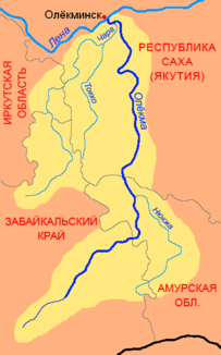
Location of the Tschara (Чара) in the catchment area of the Oljokma |
||
|
Mineral charoite |
||
The Tschara ( Russian Чара ) is a 851 kilometer long left tributary of the Oljokma in Eastern Siberia ( Russia , Asia ).
course
The Tschara flows from Lake Bolschoje Leprindo (Great Leprindo Lake) in the north of the Transbaikalia region, at an altitude of 975 m on the southern flank of the over 3000 m high Kodar Mountains . It flows strongly meandering in a north-easterly direction through the Upper Tscharasenke , a basin that extends for more than 100 kilometers between the Kodar Mountains in the north and the only slightly lower Kalar Mountains in the south. Here the Tschara passes the so-called Tschara-Sands (Tscharskije peski) , a 37 km² large sand dune area .
Later the river turns in a north to north-west direction and cuts through many rapids forming the main ridge of the Kodar Mountains. In the further course the Tschara flows in wide arches through the low mountain range on the eastern edge of the Patom highlands and reaches the Irkutsk Oblast .
In the lower reaches, now in the Republic of Sakha (Yakutia) , the river turns again in an easterly direction and finally flows into the lower reaches of the Oljokma about 25 kilometers southeast of Oljokminsk at a height of 126 m , only about 25 kilometers above its confluence with the Lena .
The most important tributaries are the Schuja (length 337 km) and Molbo (334 km) from the left and the Tokko (446 km) from the right.
Hydrography
The catchment area of the Tschara covers 87,600 km². In the vicinity of the mouth, the river is over 500 meters wide and over 4 meters deep; the flow velocity is 1.2 m / s.
The Tschara freezes from late October to mid-May and floods from May to September. The water flow near the mouth is about 900 m³ / s on an annual average, above the mouth of the Tokko still 639 m³ / s with a minimum of 42 m³ / s in March and a maximum of 2352 m³ / s in June.
Infrastructure and economy
The Tschara is navigable for 416 kilometers from the confluence of the Shuja.
The area through which the Tschara flows is generally very sparsely populated. On the upper reaches, the Baikal-Amur-Magistrale (BAM) follows the river for about 100 kilometers between the Leprindo and Ikabja stations . The railway line runs in the immediate vicinity of the river's origin on Lake Leprindo and crosses it in front of the Novaya Chara station and urban settlement (route kilometers 1755 from Tayshet ). Near the village is Chara , administrative center of the Rajons Kalarski the Trans-Baikal region. Practically the only roads in the region through which the Tschara flows also run in the BAM area.
A few towns are only back on the lower reaches of the river, including the village of Tokko above the mouth of the tributary of the same name.
The rare mineral or coveted gemstone, charoite, was named after the chara . It was discovered in the area between Chara and Tokko in 1948 and only became known outside the Soviet Union from the 1970s .
In the area of the upper catchment area of the Tschara there are some significant ore deposits, such as one of the world's largest copper ore deposits (estimated 20 million tons of copper) in the Udokan Mountains of the same name , the eastern continuation of the Kalar Mountains.

