
Novaya Tschara
| Urban-type settlement
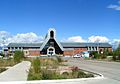
Novaya Tschara
Новая Чара
|
||||||||||||||||||||||||||||
|
||||||||||||||||||||||||||||
|
||||||||||||||||||||||||||||


Nowaja Tschara ( Russian Новая Чара ) is an urban-type settlement in the Transbaikalia region ( Russia ) with 4315 inhabitants (as of October 14, 2010).
geography
The settlement is located in the Upper Charas Basin , which is enclosed in the northwest by the Kodar Mountains and in the southeast by the Udokan Mountains , two mountain ranges up to 3000 meters high in the eastern part of the Stanovo Highlands . Nowaja Tschara is located about 600 kilometers (as the crow flies) northeast of the regional capital Tschita not far from the right bank of the Tschara river .
The settlement belongs to Kalarski Rajon , the administrative center of which, the village of Tschara , is about 10 kilometers (16 kilometers by road) to the north.
Novaya Chara station

The Tschara sands , a " desert " in the middle of Siberia, not far from Novaya Tschara. In the background the Kodar Mountains


history
The place was created in the early 1980s not far from the old village of Tschara, named after the river, in connection with the construction of the Baikal Amur Mainline (BAM). The place name accordingly stands for New Tschara . The railway station and settlement were built by construction workers from the then Kazakh SSR (as part of the propaganda about the All- Union Komsomol building object BAM, one or more regions of the former Soviet Union took over sponsorship of most of the stations and settlements to be built along the route).
Regular rail traffic on the entire section from Tynda in neighboring Amur Oblast to Novaya Tschara (from the east) began in 1988, between Lake Baikal ( Severobaikalsk ) and Novaya Tschara (from the west) in 1989. After the completion of the railway line and as a result of the economic crisis in the 1990s, a good half of the residents left the place because the expectations for the economic development of the area linked to the construction of the railway line were not fulfilled.
Population development
| year | Residents |
|---|---|
| 1989 | 8787 |
| 2002 | 4693 |
| 2010 | 4315 |
Note: census data
Culture and sights
Nowaja Tschara is the starting point for trekking tours in the nearby Kodar Mountains, one of the highest and, thanks to BAM, best accessible high mountains in Siberia outside of the South Siberian Mountains , as well as the Tschara Sands (Tscharskije peski) , a 37 km² sand dune area northwest of the town beyond the Tschara.
Economy and Infrastructure
Novaya Tschara is an important station on the Baikal-Amur Mainline (1719 km from Taischet ), which is practically the only economic factor of the place. The route crosses the Tschara six kilometers west of the settlement on a 276 meter long bridge.
However, the place has significant potential as the logistic center of a developing mining area. Between the station and Tscharabrücke a railway complex, built between August 1998 and September 2001, 66-kilometer-long branches (72 km from Novaya Chara) in a southwesterly direction to the titanium - vanadium - iron ore deposit Tschineiskoje (Tschina) from. It is the largest titanium deposit in Russia and - with a vanadium content (V 2 O 5 ) of up to 1.2 percent - the largest explored vanadium deposit in the world in terms of total reserves, the by-products of nickel , cobalt , platinum , palladium , rhodium , Contains iridium , silver and gold . Since the mining of the ore deposit located at a height of 2000 meters was initially not started due to unclear ownership and financing, the route, which was not maintained for this reason, was damaged by landslides and underwashing, so that today (2008) it is only driven for 26 kilometers. The ore, which has so far been extracted in small quantities, is transported by truck to the loading point there. The restoration of the entire route and its extension to the Udokanskoye copper deposit 13 kilometers away (also one of the world's largest with an estimated reserves of 20 million tons) is planned. In the catchment area of the route there are also deposits of rare earth metals (Katuginskoje) , iron ores (Sulumatskoje) and high-quality hard coal ( Tschitkandinskoje , also Tschitkanda ), which, like Udokanskoje , have so far been undeveloped.
The road following the BAM leads through Novaya Tschara. The settlement has a small airport.
Individual evidence
- ↑ a b Itogi Vserossijskoj perepisi naselenija 2010 goda. Tom 1. Čislennostʹ i razmeščenie naselenija (Results of the All-Russian Census 2010. Volume 1. Number and distribution of the population). Tables 5 , pp. 12-209; 11 , pp. 312–979 (download from the website of the Federal Service for State Statistics of the Russian Federation)
- ↑ Viktor werti: Tschina natschinajetsja s dorogi . In Trud , September 28, 2001 (Russian)
- ↑ Article by Sergei Rintschinow at metaltorg.ru, October 17, 2008 (Russian)
| Cities |
Balei R | Borsja R | Chilok R | Krasnokamensk R | Mogocha R | Nerchinsk R | Petrovsk-Sabaikalsky S / R | Schilka R | Sretensk R | Tschita S / R |
|
| Urban-type settlements |
Aginskoje S / R * | Aksjonowo-Silovskoye | Amasar | Arbagar | Atamanovka | Baljaga | Bukachacha | Cholbon | Darassun | Dawenda | Drovjanaja | Gorny S / G | Itaka | Jablonowo | Yasnogorsk | Kalangui | Karymskoye R | Klitschka | Klyuchevsky | Kokui | Ksenevka | Kurort-Darassun | Mogoitui R * | Mogson | Novaya Chara | Novokruchininsky | Novoorlowsk | Novopavlovka | Olowjannaja R | Orlowski | Pervomaiski | Priargunsk R | Priiskowy | Sabaikalsk R | Sherlovaya Gora | Shireks | Solotorechensk | Tarbagatai | Chernyshevsk R | Ust-Karsk | Vershino-Darasunski |
|
| Other Rajon centers |
Aksha | Alexandrovsky Zavod | Duldurga * | Gasimursky Zavod | Kalga | Krasny Chikoi | Kyra | Nerchinsky Zavod | Nizhny Zassutschei | Schelopugino | Tschara | Tupik | Uljoty | Werch-Ussugli |