
Chernyshevsk
| Urban-type settlement
Chernyshevsk
Чернышевск
|
||||||||||||||||||||||||||||||||
|
||||||||||||||||||||||||||||||||
|
||||||||||||||||||||||||||||||||
| List of large settlements in Russia | ||||||||||||||||||||||||||||||||


Chernyshevsk ( Russian Чернышевск ) is an urban-type settlement in the Transbaikalia region ( Russia ) with 13,359 inhabitants (as of October 14, 2010).
geography
The settlement is located in the north of the left Amur -Quellflusses Shilka in Trans-Baikal extending low mountain range , about 300 kilometers east of the regional capital of Chita . On the outskirts, the Aleur river flows into the Kuenga , a left tributary of the Schilka.
The Chernyshevsk settlement is the administrative center of the raion of the same name .
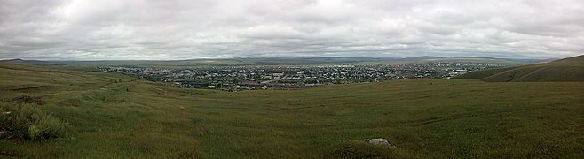
Panorama of the Chernyshevsk settlement

Chernyshevsk-Sabaikalsky depot


history
Around 1891 was far from a small Buryat the settlement of the village as part of Cossacks in Transbaikalia the Vorwerk Popowskaja wysselka that soon the village Paschennoje developed.
In 1907, starting from the Kuenga station of the then branch of the Trans-Siberian Railway to Sretensk , the construction of the Amur railway towards Khabarovsk , which passed not far from the village, began. This is where the Paschennaya station and associated settlement emerged. Operations started around 1910; the entire Amur Railway to Khabarovsk, subsequently part of the Transsib main line, was completed in 1916.
Village and station settlement gradually grew together, and in 1938 the status of an urban-type settlement was awarded, after the politician Lazar Kaganovich - at this time traffic and heavy industry minister of the Soviet Union - the name imeni Kaganowitscha received. In 1956, as part of the de-Stalinization , the place was given its current name in honor of the writer Nikolai Tschernyshevsky , who was exiled to Transbaikalia from 1864 to 1883 .
Population development
| year | Residents |
|---|---|
| 1939 | 9,704 |
| 1959 | 11,412 |
| 1970 | 13,073 |
| 1979 | 15,464 |
| 1989 | 16,204 |
| 2002 | 13,031 |
| 2010 | 13,359 |
Note: census data
Economy and Infrastructure
Chernyshevsk is the station of the Trans-Siberian Railway (station name Chernyshevsk-Sabaikalski ; route kilometers 6587 from Moscow ; electrified since 1988), from which a 72-kilometer route branches off to the mining town of Bukachacha .
The railway is the main economic factor of the place. Until the completion of the M58 Amur to Khabarovsk highway, Chernyshevsk was the end point of the western section Chita – Chernyshevsk and is part of the trans-Siberian road connection. Until the final completion and complete asphalting of the trunk road in 2010, the station was important for the reloading of vehicles and goods to the railroad.
Web links
Individual evidence
- ↑ a b Itogi Vserossijskoj perepisi naselenija 2010 goda. Tom 1. Čislennostʹ i razmeščenie naselenija (Results of the All-Russian Census 2010. Volume 1. Number and distribution of the population). Tables 5 , pp. 12-209; 11 , pp. 312–979 (download from the website of the Federal Service for State Statistics of the Russian Federation)
| Cities |
Balei R | Borsja R | Chilok R | Krasnokamensk R | Mogocha R | Nerchinsk R | Petrovsk-Sabaikalsky S / R | Schilka R | Sretensk R | Tschita S / R |
|
| Urban-type settlements |
Aginskoje S / R * | Aksjonowo-Silovskoye | Amasar | Arbagar | Atamanovka | Baljaga | Bukachacha | Cholbon | Darassun | Dawenda | Drovjanaja | Gorny S / G | Itaka | Jablonowo | Yasnogorsk | Kalangui | Karymskoye R | Klitschka | Klyuchevsky | Kokui | Ksenevka | Kurort-Darassun | Mogoitui R * | Mogson | Novaya Chara | Novokruchininsky | Novoorlowsk | Novopavlovka | Olowjannaja R | Orlowski | Pervomaiski | Priargunsk R | Priiskowy | Sabaikalsk R | Sherlovaya Gora | Shireks | Solotorechensk | Tarbagatai | Chernyshevsk R | Ust-Karsk | Vershino-Darasunski |
|
| Other Rajon centers |
Aksha | Alexandrovsky Zavod | Duldurga * | Gasimursky Zavod | Kalga | Krasny Chikoi | Kyra | Nerchinsky Zavod | Nizhny Zassutschei | Schelopugino | Tschara | Tupik | Uljoty | Werch-Ussugli |