R297 (Russia)
| Road of federal importance | ||
|
||
| R297 Amur | ||
|---|---|---|
| Basic data | ||
| Overall length: | 2165 km | |
|
Federation subjects : |
|
|
| Asian Highway : | AH 30 | |
| map | ||
| R297 in Russia's trunk road network | ||
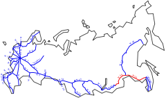
R297 Amur is the name of a Russian highway in Siberia and the Far East . It leads over a total length of 2165 km from Chita to Khabarovsk largely along the eponymous river Amur .
The Amur Main Line is the last section of the transcontinental road connection from Moscow to Vladivostok . Until the road was opened, the Russian areas on the Pacific coast were only connected to the rest of the country by airlines and the Trans-Siberian Railway and the Baikal-Amur Mainline .
Together with the A370 Ussuri (formerly M60), the Amur main line forms the AH 30 (Chita – Vladivostok) in the Asian trunk road project . The branch line to Blagoveshchensk is part of AH 31 , which continues on Chinese territory (as G202 ) via Harbin and Shenyang to Dalian on the Yellow Sea .
history
The Council of Ministers of the USSR decided to build the road in 1966. In the following ten years the route was planned and other preparations made. Construction finally began in 1978. By 1995, 605 of the more than 2000 kilometers of track had been built. That corresponds to a construction rate of 35 kilometers per year. The construction was made more difficult not only by financial difficulties, but also by the special features of the terrain, because a large part of the route runs through previously completely undeveloped areas of the taiga . A total of 26 bridges had to be built. In 2001 construction was accelerated: a quarter of the funds earmarked for road construction in the Russian state budget now went into the project. The official opening of the street by President Vladimir Putin took place on February 26, 2004. At this point in time, the route was already passable, but not yet completely paved. The asphalting of the entire route was completed on September 24, 2010, with old areas of the route having to be re-paved due to heavy wear and tear.
The street was given the number R297 in 2010. Previously, it was initially only called Amur , later also the number M58.
course
- Chita ( Transbaikalia region ), end point of the R258; Branch from the AH 30
- Novotroitsk
- Naryn-Talacha
- Chernyshevsk
- Sbega
- Mogocha
- Amasar
- Amur Oblast
- Tachtamygda
- Skoworodino , junction of the A361 to Jalinda , border with the People's Republic of China
- Newer , branch of the A360 Lena to Nizhny Bestjach near Jakutsk
- Magdagachi
- Siwaki
- Muchino
- Bereja
- Shimanovsk
- Chernovka
- Svobodny
-
Belogorsk , branch of a branch line to Blagoveshchensk (AH 31)
- Srednebelaya
- Ivanovka
- Blagoveshchensk
- Savitinsk
- Novobureiski
- Jewish Autonomous Oblast
- Obluchye
- Birobidzhan
- Khabarovsk region
- Khabarovsk , terminus of the A370 Ussuri and the A375 Vostok


