Mogocha
| city
Mogocha
Могоча
|
||||||||||||||||||||||||||||||||||
|
||||||||||||||||||||||||||||||||||
|
||||||||||||||||||||||||||||||||||
| List of cities in Russia | ||||||||||||||||||||||||||||||||||
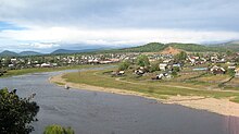
Mogotscha ( Russian Могоча ) is a small town in the Transbaikalia region ( Russia ) with 13,258 inhabitants (as of October 14, 2010).
geography
The town lies at the foot of in the eastern Trans-Baikal extending Amasargebirges , about 600 kilometers east-northeast of the regional capital of Chita . Here the Mogotscha river flows into the Amasar , a left tributary of the Amur .
The city of Mogocha has been the administrative center of the Mogocha Rajon of the same name since 1926 . The settlements Medweschi Klyuch , Rasdolnoye and the Penkovaya railway station are administratively subordinate to the city.
climate
The area around Mogocha with average January temperatures below -30 ° C and an absolute minimum below -60 ° C, the coldest winter along the Trans-Siberian .
history
The place arose from 1908 in connection with the construction of the Amur railway towards Khabarovsk , when a large station was built here. The official founding year of the place is 1910, the railway operation started in 1914. The name was given after the river its name again to the ewenkische word mongotschi back that (the clan) Mongo belonging means.
Mogocha quickly developed into a transshipment point and starting point for supplying the mining industry in eastern Transbaikalia and the northern areas of the region in general. In the 1920s, gold mining began in the area, especially after the establishment of the " Trust " Werchamursoloto (ie Upper Amur Gold ) in 1934. In 1930 Mogocha was given the status of an urban-type settlement .
In 1949 a road from Mogotscha to Tschara in the north of what was then Chita Oblast was opened in winter (accessible today with the Baikal-Amur mainline). In 1950 city rights were granted.
From 1947 to 1953, the administration was in the Mogocha Kljutschewski -Strafgefangenenlagers ( "Kljutschewlag") in the system of the Gulag . The up to 3,000 prisoners were mainly deployed in the molybdenum and gold mines near the Dawenda and Klyuchevsky settlements 40 to 50 kilometers to the southwest .
Population development
| year | Residents |
|---|---|
| 1917 | 1,780 |
| 1922 | 3,962 |
| 1939 | 20,098 |
| 1959 | 14,652 |
| 1970 | 17,884 |
| 1979 | 17,766 |
| 1989 | 17,847 |
| 2002 | 13,282 |
| 2010 | 13,258 |
Note: from 1939 census data
Culture and sights
In the city there is a history and local history museum set up at the railway depot .
Economy and Infrastructure
In Mogotscha there is an important station of the Trans-Siberian Railway (route kilometers 6906 from Moscow ; electrified since 1994). Since 1960 she is the administrative center of a section of the Trans-Baikal Railway (regional management of Russian Railways ), the 764 kilometers of the Trans-Siberian main line between Shilka and already in the Amur Oblast located Uruscha includes. In addition to railway workshops, there are forestry, wood processing and food industries.
In the Rajon gold deposits are mined by several mining companies ("Rudnik Kljutschi") and Artels ("Amasar", "Priisk Mogotschinski", "Tungir"), whose administrations and supply bases are located in Mogotscha.
About eight kilometers south of the city, the M58 Amur to Khabarovsk trunk road, which is currently under construction , is part of the trans-Siberian road link.
A small airport that had been in operation since 1937 was closed in the 1990s.
Sons and daughters of the place
- Natella Archipowna Krasnikowa (* 1953), former field hockey player
Web links
- Mogotscha in the Encyclopedia of Transbaikaliens (Russian)
Individual evidence
- ↑ a b Itogi Vserossijskoj perepisi naselenija 2010 goda. Tom 1. Čislennostʹ i razmeščenie naselenija (Results of the All-Russian Census 2010. Volume 1. Number and distribution of the population). Tables 5 , pp. 12-209; 11 , pp. 312–979 (download from the website of the Federal Service for State Statistics of the Russian Federation)


