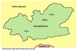
Agin Buryat Autonomous Okrug
Agin Buryat Autonomous Okrug
|
|||||
|---|---|---|---|---|---|
| State : | Russia | ||||
| Federal District : | Siberia | ||||
| Area : | 19,300 km² | ||||
| Residents : | 74,232 (January 1, 2006) | ||||
| Capital : | Aginskoye | ||||
| Population density : | 3.8 inhabitants per km² | ||||
| License plate : | 80 | ||||
The Autonomous Okrug of the Agin Buryats ( Russian Агинский Бурятский автономный округ Aginsky Buryatsky awtonomny okrug ) is a former administrative region ( Autonomous Okrug ) in Russia . It was located as an exclave within the Chita Oblast and was united with it in 2008 to form the Transbaikalia region .
geography
The small autonomous district was in south-eastern Siberia near the Mongolian border. It was completely enclosed by the Chita Oblast and thus formed an enclave .
The Alkhanai National Park, established in 1999, was located on the territory of the district .
population
The titular nation was the Buryats , a Mongolian people who also live in the Russian Republic of Buryatia . The Buryats made up 45,149 (= 62.52%) of the population at the 2002 census. In addition, the statisticians determined 25,366 (= 35.13%) Russians and 390 (= 0.54%) Tatars . The total population in 2002 was 72,213 people.
| Ethnic group | VZ 1959 | VZ 1970 | VZ 1979 | VZ 1989 | VZ 2002 | |||||
|---|---|---|---|---|---|---|---|---|---|---|
| number | % | number | % | number | % | number | % | number | % | |
| Buryats | 23,374 | 47.6% | 33.117 | 50.4% | 35,868 | 52.0% | 42,362 | 54.9% | 45.149 | 62.5% |
| Russians | 23,857 | 48.6% | 28,966 | 44.0% | 29,098 | 42.1% | 31,473 | 40.8% | 25,366 | 35.1% |
| Tatars | 320 | 0.7% | 1,053 | 1.6% | 840 | 1.2% | 611 | 0.8% | 390 | 0.5% |
| Ukrainians | 458 | 0.9% | 788 | 1.2% | 810 | 1.2% | 823 | 1.1% | 190 | 0.3% |
| Evenks | 42 | 0.1% | 177 | 0.3% | 226 | 0.3% | 166 | 0.2% | 164 | 0.2% |
| Bashkirs | 36 | 0.1% | 385 | 0.6% | 300 | 0.4% | 237 | 0.3% | 126 | 0.2% |
| Other | 1,022 | 2.1% | 1,252 | 1.9% | 1,893 | 2.7% | 1,516 | 2.0% | 828 | 1.1% |
| Residents | 49.109 | 100% | 65,768 | 100% | 69,035 | 100% | 77,188 | 100% | 72.213 | 100% |
history
The Agin Buryat territory became part of Russia in 1648 . Russian colonization began soon afterwards . In 1937 the National Circle of Agin Buryat Mongols was established within the framework of the RSFSR . It was 1958 in the National Circle of Aginer Buryat and according to the Constitution of 1977 in Agin-Buryat Autonomous Okrug renamed. After the collapse of the Soviet Union , he became a federal subject of Russia in 1992 . On March 1, 2008, the Autonomous Okrug was combined with Chita Oblast to form a larger administrative unit, the Transbaikalia region . Since 2008, the Agin Buryat Okrug has existed within the Transbaikalia region as an administrative unit without autonomy within the Russian Federation.
The head of government was Bair Bajaschalanowitsch Shamsuev until 2008.
economy
The traditional industries of the Buryats are horse and camel breeding , which are still important today. Mining played a role, including gold and bismuth . Important branches of industry were metal processing and energy generation .
Administrative division
(Resident on January 1, 2006)
| Rajon | Residents | Urban population | Village population | Administrative headquarters |
|---|---|---|---|---|
| Aginskoye | 31,044 | 18,140 | 12,904 | Aginskoye |
| Duldurga | 15,743 | - | 15,743 | Duldurga |
| Mogoitui | 27,445 | 9,349 | 18.096 | Mogoitui |
Cities
The capital and only major city of the district was Aginskoye . In the district there were no places with city rights, but only 4 urban settlements in addition to the villages .
|


