Lena Angara Plateau
| Lena Angara Plateau | ||
|---|---|---|
| Highest peak | Namai ( 1509 m ) | |
| location | Irkutsk Oblast ( Russia ) | |
|
|
||
| Coordinates | 55 ° 30 ′ N , 105 ° 0 ′ E | |
| rock | Limestone , sandstone | |
| Age of the rock | Cambrian - Ordovician (540-450 mya ) | |
| surface | 20,000 km² | |
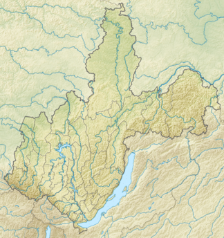
The Lena Angara Plateau ( Russian Лено-Ангарское плато , Leno-Angarskoje plato ) is a low mountain plateau in southern Eastern Siberia that reaches heights of up to 1500 m .
geography
The plateau extends between the middle reaches of the biggest Yenisei -Nebenflusses Angara and its left tributary of the Oka and the right Lena creek Kirenga . In the west and north-west it is bounded by the Angara ridge , in the north it gradually merges into the Central Siberian mountainous region , in the east it is separated from the Baikal Mountains by a depression , in the south by the Irkutsk - Cheremkhovo plain from the Eastern Sayan, which extends from the upper reaches of the Angara to the north-west . The extension in north-south direction is about 600 kilometers, in west-east direction up to 380 kilometers; it thus occupies an area of over 20,000 km².
Overall, the plateau slopes from south to north: in the southern part its average height above sea level is 1,100 meters, in the north 500 meters. The peaks are mostly flattened, the river valleys cut 200 to 600 meters deep. Individual mountain massifs tower above the plateau, such as that of Namai on the eastern edge of the plateau, with 1509 m (according to older information 1464 m ) the highest peak of the mountain ( location ).
The rivers crossing the Lena-Angara plateau have predominantly south-north flow directions. These include the Oka on the western edge of the plateau and the Angara to which it flows. Both are there in the dam area of the Bratsker dam . The southern part of the plateau is drained by a multitude of shorter rivers that flow into the Angara from the right, including the Kuda , Ida , Ossa and Obussa . The Angara tributary Ilim and its right tributary Kotschenga run further east . The central part of the plateau is traversed by the Lena, into which the rivers Kulenga , Ilga and Kuta (with tributary Kupa ) flow from the left and Tutura , Orlinga , Iga and Tajura from the right . The eastern border forms the larger right Lena tributary Kirenga , into which the Chanda flows from the left, flowing through the highest part of the Lena Angara plateau .
Administratively, the area belongs to the Irkutsk Oblast .
geology
The Lena Angara Plateau is formed by clastic and chemical sedimentary rocks (such as sandstone and limestone ) from the Cambrian and Ordovician . The solid Ordovician limestone rocks are responsible for the flat mountain tops of the area.
The most important mineral resources are iron and copper ores , rock salt and building materials. Iron ore is mined near Schelesnogorsk-Ilimski .
vegetation
The entire area is covered by taiga (boreal coniferous forest), the predominant tree species of which are larch , Siberian stone pine , spruce and pine . Few of the highest peaks are bare in the summit area.
Development
Overall, the Lena Angara Plateau is only sparsely populated. The southern part of the upper reaches of the Angara in the north-west of Irkutsk is relatively densely populated, partly on the territory of the former Ust-Ordynsk Buryat Autonomous Okrug , which became the Irkutsk Oblast . A number of villages are located in the area of the plateau on the upper reaches of the Lena, including Schigalowo . The Lena is also followed by a road that has been completed in recent years, which crosses the plateau in a south-north direction.
In the 1950s, a railway line was built, coming from Taischet and east of Bratsk, crossing the northern part of the plateau via Schelesnogorsk-Ilimski to Ust-Kut an der Lena with the following road. In the 1970s, this railway line was extended from Ust-Kut as the Baikal-Amur Magistrale in the direction of Lake Baikal to the east, with the first 170 kilometers between Ust-Kut and Magistralny crossing the northeast part of the Lena-Angara plateau.
Individual evidence
- ↑ Article Lena-Angara-Plateau in the Great Soviet Encyclopedia (BSE) , 3rd edition 1969–1978 (Russian)
- ↑ Soviet General Staff Map 1: 100,000. Sheet N-48-22. Edition 1986
- ↑ Great Soviet Encyclopedia, s. swell
