
Novaya Zemlya
| Novaya Zemlya | ||
|---|---|---|
 |
||
| Waters | Arctic Ocean | |
| Geographical location | 74 ° 0 ′ N , 56 ° 0 ′ E | |
|
||
| Number of islands | 2 main islands | |
| Main island |
South Island (Novaya Zemlya) North Island (Novaya Zemlya) |
|
| Total land area | 90,650 km² | |
| Residents | 2429 (2010) | |
 Middle: Novaya Zemlya . Right: Yamal Peninsula and Obbusen |
||


Nowaja Semlja ( Russian Новая Земля / Nowaja Semlja 'new land') is a double Russian island that lies west of the inner Eurasian border in the Arctic Ocean and is part of Europe . It is part of Arkhangelsk Oblast .
geography
The slightly sickle-shaped double island is the eastern boundary of the Barents Sea and the western of the Kara Sea . The latter is the inner Eurasian estuary of the great Siberian rivers Ob and Yenisei and is significant for the humid island climate.
The almost uninhabited archipelago consists of two large islands (North Island and South Island) and many small islands and numerous islets . Together they have an area of 90,650 km². The two main islands are separated by the very narrow Matotschkin Schar strait . Nowaya Zemlya is a total of almost 900 kilometers (center line) and is between 470 and 1175 kilometers beyond the Arctic Circle :
- The North Island (Sewerny Ostrow) , which rises up to 1590 meters from the Arctic Ocean , is the fourth largest island in Europe with 48,904 km². Depending on its location at 73 to 77 degrees ( geographical latitude ), it is heavily glaciated: the ice is up to 400 meters thick.
- The South Island (Juschny Ostrow) , which rises up to 1,342 meters from the Arctic Ocean, is the sixth largest island in Europe with 33,275 km². In contrast to the North Island, tundra and frost rubble deserts predominate here , although it is still around 71 to 73 degrees from the equator.
The third largest island in the archipelago is Meschduscharski in the southwest. As a southern continuation of Novaya Zemlya, the Waigatsch -Insel the southeast the bordering the South Island Kara Strait connects, the Pai Choi mountains that the bordering Waigatsch southeast yugorsky strait is on the mainland, and the Urals , the south of the Kara Sea and extending southwards directly from the Pai Choi Mountains and forming the border between Europe and Asia.

Cape Schelanija, northern tip of the North Island (76 ° 57'N, 68 ° 35'E)
Cape Schelanija, research station of the "Russian Arctic" National Park
(with polar bears)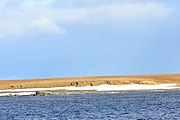
Barents Bay:
Region where the grave of Willem Barents is believed to be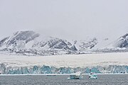
Inostranzew Bay:
Inostranzew Glacier (76 ° 30'N, 60 ° 5'E)


climate

The climate, which is determined by the Kara Sea and the currents that flow into it, is arctic with severe winters and cool summers. The west coast of Novaya Zemlya is only free of snow for a few weeks in summer.
The annual average temperature at the Malyje Karakuly weather station on the west coast of the South Island is −5.7 ° C; the warmest months are July and August with 6.0 ° C each, the coldest January and March with −15.0 ° C. The annual rainfall is 317 mm and is fairly evenly distributed over the year, with a slight maximum from August to October.
Like the entire Arctic region, Novaya Zemlya is also affected by global warming . In February 2019, it was reported that up to 52 polar bears were temporarily staying near and in human settlements such as Beluschja Guba on the South Island, searching for food. One of the reasons was suspected to be the lack of pack ice around the islands, which meant that the bears could not reach their actual hunting grounds and were forced to move to the mainland.
history

The Russians have probably known Novaya Zemlya since the 11th and 12th centuries, despite its northern location. However, it was not until the 16th century that Western Europeans became aware of the double island (partly Latinized as Nova Zembla , still the Dutch name today ) when they were looking for a possible northeast passage from Europe to the Pacific . In 1553, Sir Hugh Willoughby was the first Western European to sight the island, but did not go ashore. It is already listed as Nova Zemla on Gerhard Mercator's large world map from 1569 . From 1594–1597 the Dutchman Willem Barents explored the islands, undertook the first winter in the Arctic and died there in 1597. The expedition member Gerrit de Veer observed the Novaya Zemlya effect there , which was only explained in the 1990s. The Dutch named the islands "New Holland" after JN Bellin on his island map published in Paris in 1758.
The first Samoyed settlement was established in 1872 on Kostin Schar on the west coast of the South Island. In 1875 a rescue station was established in Malyje Karmakuly, and soon thereafter the local meteorological station too. In 1894 a regular steamboat connection was established from Arkhangelsk to Novaya Zemlya. In the early 1940s, around 350 people lived in ten colonies on the twin island, including one on the east coast of the North Island.
From 1907 to 1913, the Russian geologist Vladimir Alexandrowitsch Russanow explored the area in six expeditions. He discovered the numerous raw material deposits on the islands, in 1908 he managed the first west-east crossing of Novaya Zemlya, in 1910 he navigated around the North Island for the first time, and in 1911 he circumnavigated the South Island.
In the summer of 1943, the German submarine U 387 brought an automatic weather station to Novaya Zemlya. The device with the code name "Gerhard" was set up south of Inostranzew Bay. “Gerhard” independently recorded weather data and transmitted it in encrypted form to the German marine weather service . A year later, the submarine brought another weather radio to Novaya Zemlya. This was code-named "Erich" and was set up on the north side of the bay.
From December 2018 to February 10, 2019, 52 polar bears appeared in the main settlement of the double island, Beluschja Guba , and sometimes chased or attacked people. This polar bear invasion is the strongest since 1983 and is attributed to the decline in polar ice and thus the habitat of white bears in the wake of the climate crisis .
Nuclear test area

From 1955 Novaya Zemlya was used under the code name "Object 700" for nuclear weapon tests by the Soviet Union . Among other things, the so-called Tsar bomb was tested over this area , which with 57 megatons TNT equivalent is the largest nuclear fusion weapon ever detonated . A total of 130 nuclear weapons tests had been carried out in three zones in the area by 1990, including 88 atmospheric, 39 underground and three underwater. According to various reports, large amounts of radioactive waste are stored on the island and in the waters off it .
Residents and economy
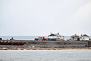
The islands, which form a "municipal entity" (munizipalnoje obrasowanije) with the status of an urban district (gorodskoi okrug) of the Arkhangelsk Oblast, today have 2429 inhabitants ( 2010 census ), of which 1972 in the main town of Beluschja Guba on the west coast of the South Island and 457 in Rogachovo 12 km away . There are no other permanently inhabited places. Most of the inhabitants belong to the indigenous population, the Nenets . The fishing and fur hunting , especially in the Arctic fox , play a major role in Novaya Zemlya.
To the south of the Barents Sea , the Priraslomnoye oil field with around 73 million tons is being developed offshore . In addition, copper and hard coal are mined on the islands .
geophysics
Various research stations on the islands are used for meteorology and geophysics. Among other things, wind and ocean currents , the earth's magnetic field and the northern lights are researched. Such research was deepened from the International Geophysical Year 1957/58 and also through later international collaborations.
Around 1980, New York geophysicists examined the records of strong seismic waves that produced two Russian nuclear tests on Novaya Zemlya in 1971 and 1974. First they calculated that the inner core of the earth rotates one degree faster than the earth's mantle every year . This scientific sensation did not last long because it was based on a flawed assumption.
Another project did not analyze the quake waves reflected on the earth's core, but rather the scattered earthquake waves (→ seismic ). From the differences in the running times from 1971/74, the scientists calculated that the core actually “hurries ahead” of the Earth's mantle, but only by 0.15 degrees per year. These results are significant for the physics of the whole earth body and also for the earth's rotation and astronomy.
Web links
- History and landscape
- Wiener Zeitung : The Austro-Hungarian North Polar Expedition 1872–1874 ( Memento from April 24, 2002 in the Internet Archive )
Individual evidence
- ↑ Der Standard : Polar Bear Danger in Russia due to Global Warming , February 17, 2019
- ↑ Der Standard : "Invasive Polar Bears" withdraw from Siberian island , February 18, 2019
- ^ Leonid Breitfuss : The north polar region. Its nature, meaning and research , Springer-Verlag, Berlin 1943, p. 101.
- ↑ Franz Selinger: From “Nanok” to “Eismitte”. Meteorological ventures in the Arctic 1940–1945. Convent, Hamburg 2001, ISBN 3-934613-12-8 , page 311.
- ^ Siberian Island: State of emergency due to "aggressive polar bears" orf.at, February 9, 2019, accessed February 10, 2019.
- ↑ a b Nuclear Explosions in the USSR: The North Test Site Reference Material (PDF; 1.5 MB) International Atomic Energy Agency . December 2004. Retrieved February 11, 2010.
- ↑ http://www.berliner-zeitung.de/archiv/drei-zdf-reportagen-ueber-bisher-geheime-regionen-der-ehemaligen-sowjetunion-die-zeitbombe-auf-objekt-700,10810590,9221006.html
- ↑ Öko-Test: What to do with the nuclear waste? ( Memento from March 4, 2016 in the Internet Archive ) (Archive link)
- ↑ Rosneft to Transport Siberian Oil through the Northern Sea Route ( Memento of May 3, 2008 in the Internet Archive ) ( archive link)
- ↑ Nature , Volume 405.
Districts : Arkhangelsk | Koryashma | Kotlas | Mirny | Novaya Zemlya | Novodvinsk | Severodvinsk
Rajons : Kholmogorsky | Kargopolski | Konoschski | Kotlasski | Krasnoborsky | Lenski | Leschukonski | Mesenski | Nyandomski | Oneschski | Pineschski | Plesetsky | Primorsky | Schenkurski | Ustyansky | Catfish | Verkhnoyemsky | Wilegodski | Winogradowski