Matochkin crowd
| Matochkin crowd | ||
|---|---|---|
| Novaya Zemlya with Matochkin crowd | ||
| Connects waters | Barents Sea | |
| with water | Kara Sea | |
| Separates land mass | North Island (Novaya Zemlya) | |
| of land mass | South Island (Novaya Zemlya) | |
| Data | ||
| Geographical location | 73 ° 19 ′ N , 55 ° 24 ′ E | |
|
|
||
| length | 100 km | |
| Smallest width | 600 m | |
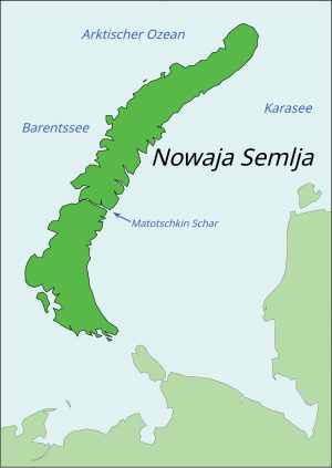
The Matotschkin Schar ( Russian Ма́точкин Шар , wiss. Transliteration Matočkin Šar , rarely also Matochkin Street ) is a strait that separates the two main islands of the Novaya Zemlya archipelago , Severny Island in the north and Juschny Island in the south. The strait connects the Barents Sea in the west with the Kara Sea in the east.
The Strait of the Sea was first described in detail by Fyodor Rosmyslow during an expedition from 1768–69.
The coast along the 100 km long and at the narrowest point about 600 meters wide road is steep. Due to its location at 73 ° N, the Matochkin flock is frozen over most of the time. There are small fishing villages on the coast (Matochkin Schar, Stolbowy).
On October 30, 1961, the tsar bomb test was carried out north of the strait .
In the years 1963–1990 a total of 39 underground nuclear weapons tests were carried out on the southern edge . So-called hydronuclear tests were also carried out subsequently , albeit with a subcritical mass of fissile material.
literature
- G. Gilbo: Sprawotschnik po istorii geografitscheskich naswani na pobereschje SSSR . Ministerstwo oborony Soiusa SSR, Glaw. upr. nawigazii i okeanografii, 1985, pp. 205-206. (Russian)
- Vladimir Dmitrijew and others: Morskoi enziklopeditscheski slowar: Tom 2 . Sudostrojenije, Sankt Petersburg 1993, ISBN 5-7355-0281-6 , p. 254. (Russian)

