Jugorstrasse
| Jugorstrasse | ||
|---|---|---|
| Jugorstrasse | ||
| Connects waters | Barents Sea | |
| with water | Kara Sea | |
| Separates land mass | Russian mainland | |
| of land mass | Waigatsch | |
| Data | ||
| Geographical location | 69 ° 40 ′ N , 60 ° 20 ′ E | |
|
|
||
| length | 40 km | |
| Smallest width | 2 km | |
| The Jugor Strait separates Waigatsch Island from the mainland | ||
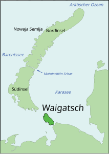
The Jugor Strait ( Russian Югорский Шар , Jugorski Schar ) is a strait in the extreme northeast of Europe . It connects the Kara Sea and the Barents Sea in northern Russia . It separates the island of Waigach from the Russian mainland and is only two kilometers wide in places, but widens to almost 10 km in the northeast.
The name is derived from the old name "Jugra" (Югра) or " Jugorien " (Югория, Jugorija ), which from the 11th to 17th centuries was the region between the Pechora and the Northern Urals and the settlement areas of the Khanty and Mansi in western Siberia designated.
literature
- G. Gilbo: Sprawotschnik po istorii geografitscheskich naswani na pobereschje SSSR . Ministerstwo oborony Soiusa SSR, Glaw. upr. nawigazii i okeanografii, 1985, p. 401. (Russian)
- A. Gorkin and others: Geografija Rossii: Enziklopeditscheski slowar . Bolschaja Rossijskaja enziklopedija, Moscow 1997, ISBN 5-85270-276-5 , p. 683. (Russian)


