Franz Josef Land
| Franz Josef Land | ||
|---|---|---|
| Map of the Franz Josef Land | ||
| Waters | Arctic Ocean | |
| Geographical location | 80 ° 40 ′ N , 54 ° 51 ′ E | |
|
|
||
| Number of islands | 191 | |
| Main island | Alexandraland | |
| Total land area | 16,090 km² | |
| Residents | 11 (2015) | |
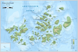
Franz Josef Land ( Russian Земля Франца-Иосифа Zemlya Franza-Iossifa ) is an archipelago in the Arctic Ocean north of the large double island of Novaya Zemlya and belongs to the Arkhangelsk Oblast in Russia . It was named in the 1870s after the Emperor of Austria and King of Hungary (see Austria-Hungary ), Franz Joseph I.
The Cape Fligely on Rudolf Island ( Ostrow Rudolfa ) is the northernmost point Eurasiens , at 81 ° 51 'north latitude . In some geographical treatises as well as articles in English, Franz Josef Land is counted as part of Asia. On Franz-Josef-Land it is polar day from April 10th to September 1st. The sun rises to a maximum of 33 ° at noon at the summer solstice. The access is not ice-free every year and only possible for visitors for a few summer weeks on one of the sporadic cruises with icebreakers . Land expeditions are generally not allowed, but there are exceptions such as the 2005 Payer-Weyprecht Memorial Expedition.
geography
The archipelago is located northwest of the Severnaya Zemlya archipelago ("Nordland"). Franz-Joseph-Land, together with the Victoria Island ( Ostrow Wiktorija ), which is 160 km to the west and closer to Spitsbergen , forms the Russian island territory of the same name, which belongs to the Arkhangelsk Oblast. The islands are divided in many ways by fjords , bays and mostly frozen straits . The northernmost point of Franz Josef Land is approx. 900 km from the geographic North Pole . Only Greenland and the small islands off the coast to the north such as Kaffeklubben Island and Ellesmere Island in the Canadian Arctic Archipelago are closer to the pole. The southernmost island of Franz Josef Land is about 370 km from Novaya Zemlya ("New Land"). Franz-Josef-Land borders the Barents Sea in the north.
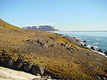
The archipelago is of volcanic origin, the highest point with 620 m is on Wiener Neustadt Island ( Ostrow Winer Neischtadt ). The total area of the islands is 16,090 km² , which roughly corresponds to the size of Styria or Thuringia . 191 islands were counted, according to another source 187, 85% of the total area of which is constantly covered with ice (as of 2003). This means that the archipelago has the highest rate of glaciation of all Arctic countries. The average ice thickness is around 180 m. Glaciers make up about 60% of the coastline.
In Franz-Josef-Land the zone time UTC + 3 is considered Moscow Standard Time (MSK) , equal to CET +2 hours. In 2007 there were still two stations that were manned all year round: the Nagurskaja weather station on Alexandraland with a winter crew of five and the geophysical observatory ET Krenkel on Hayes Island with four people.
The islands
Naming the islands

- Zemlja Alexandry ( Alexandraland ), with the Russian polar base Nagurskaja , the northernmost border protection base in Russia including a landing strip.
- Ostrow Bell ( Bell Island ), discovered by Benjamin Leigh Smith in 1880 and named after the striking mountain that resembled a bell.
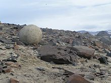
- Ostrow Tschamp ( Champ Island , named after William S. Champ ) is located in the interior of the archipelago and is best known for the appearance of concretions in the form of stone balls with a diameter of up to three meters.
- Zemlya Georga ( Prince George Land ) is the largest and longest of the islands, named by Frederick George Jackson in 1897 after George Frederick Ernest Albert , Prince of Wales, who later became King George V.
- Ostrow Greem Bell ( Graham Bell Island , named after Graham Bell ) with the longest runway in the entire archipelago (2,100 m). Heavy transport machines also started and landed here.
- Ostrow Gallja ( Hall Island , named after Charles Francis Hall ) with the striking Cape Tegetthoff and its rock needles in front of it. The cape was the first land that Payer and Weyprecht sighted after their more than twelve months long drift on the expedition ship Admiral Tegetthoff .
- Ostrow Heissa ( Hayes Island ), with the geophysical observatory " Ernst T. Krenkel ".
- Ostrow Gogenloe ( Hohenlohe Island ) with Cape Schrötter
- Ostrow Gukera ( Hooker Island ) with the Rubini Rock, the most important bird rock in the archipelago. From 1929 to 1959, the Soviet research station Buchta Tichaja was located on Hooker Island .
- Ostrow Nordbruk ( Northbrook Island , named after Thomas Baring, 1st Earl of Northbrook ), one of the southernmost islands and relatively accessible.
- Ostrow Rudolfa ( Rudolf Island ), northernmost island and starting point for pole expeditions at the end of the 19th and beginning of the 20th century (Teplitz Bay). There is a short ice landing strip on a flat glacier .
- Ostrow Wiltscheka ( Wilczek Island ), southernmost island and land first entered by Payer and Weyprecht on November 1, 1873, grave of the machinist Ota Kříž
- Semlja Wiltscheka ( Wilczek-Land ), the second largest of the islands, with Cape Heller
- Ostrow Winer Neischtadt ( Wiener Neustadt Island ) with the highest mountain in the archipelago (Parnass Peak at 620 m).
- Ostrow Ziglera ( Ziegler Island ), named after the US sponsor of two polar expeditions - the Baldwin-Ziegler Expedition 1901-1902 and the Fiala-Ziegler Expedition 1903-1905.
Islands by area
| island | Russian | Area km² |
Height m |
|---|---|---|---|
| Prince Georg Land | Земля Георга | 2820.8 | 416 |
| Wilczek Land | Земля Вильчека | 2203.3 | 606 |
| Graham Bell Island | Остров Греэм-Белл | 1556.6 | 509 |
| Alexandraland | Земля Александры | 1095.3 | 382 |
| Hall Island | Остров Галля | 1049.4 | 502 |
| Salisbury Island | Остров Солсбери | 960.0 | 482 |
| McClintock Island | Остров Мак-Клинтока | 611.5 | 521 |
| Jackson Island | Остров Джексона | 521.4 | 481 |
| La Ronciere Island | Остров Ла-Ронсьер | 478.3 | 431 |
| Hooker Island | Остров Гукера | 459.8 | 576 |
| Ziegler Island | Остров Циглера | 448.0 | 554 |
| Champ Island | Остров Чамп | 374.3 | 507 |
| Luigi Island | Остров Луиджи | 370.6 | 468 |
| Salm Island | Остров Сальм | 344.0 | 343 |
| Karl Alexander Island | Остров Карла-Александра | 329.2 | 365 |
| Rudolf Island | Остров Рудольфа | 295.5 | 461 |
| Northbrook Island | Остров Нортбрук | 288.6 | 344 |
| Eva Liv Island | Остров Ева-Лив | 288.0 | 381 |
| Wiener Neustadt Island | Остров Винер-Нёйштадт | 237.0 | 620 |
| Bruce Island | Остров Брюса | 190.8 | 301 |
| Nansen Island | Остров Нансена | 164.1 | 372 |
| Payer Island | Остров Пайера | 160.0 | 284 |
| Rainer Island | Остров Райнера | 139.8 | 284 |
| Hayes Island | Остров Хейса | 132.2 | 242 |
| Greely Island | Остров Грили | 127.2 | 447 |
| Arthur Island | Остров Артура | 111.2 | 275 |
| other islands | 333.1 | ||
| Franz Josef Land | Земля Франца-Иосифа | 16090.0 | 620 |
The islands with less than 100 square kilometers include the Alger Island (Алджер), the Becker Island (Остров Беккера), the Bell Island (Белл), the Hochstetter Islands (Острова Хохштеттера), the Hoffmann Island ( Остров Гофмана) which Gogenloe island (Гогенлоэ), the Kane-island (Остров Кейна) which koldewey island (Остров Кольдевея), the Kuhn-island (Остров Куна) Liitke island (Остров Литке), Mabel island (Мейбел), Mother-of-Pearl Island (Перламутровый) and Wilczek Island (Остров Вильчека).
climate
A harsh, arctic climate prevails in the area of the archipelago, there are often storms and especially at the end of the very short summer there is thick fog . Average temperatures are +2 ° C in summer and −22 ° C in winter . In recent years, the extreme values have been +10 ° C and -48.9 ° C. These data refer to the weather station Nagurskoye on Alexandraland (Zemlya Alexandry) in the west of the archipelago.
| Krenkel Station, Hayes Island | ||||||||||||||||||||||||||||||||||||||||||||||||
|---|---|---|---|---|---|---|---|---|---|---|---|---|---|---|---|---|---|---|---|---|---|---|---|---|---|---|---|---|---|---|---|---|---|---|---|---|---|---|---|---|---|---|---|---|---|---|---|---|
| Climate diagram | ||||||||||||||||||||||||||||||||||||||||||||||||
| ||||||||||||||||||||||||||||||||||||||||||||||||
|
Average monthly temperatures and rainfall for Krenkelstation, Hayes Island
Source:
|
||||||||||||||||||||||||||||||||||||||||||||||||||||||||||||||||||||||||||||||||||||||||||||||||||||||||||||||||||||||||
The archipelago lies on the edge of the pack ice border , which means that north of the archipelago the ice does not break up in summer, but drifts in a circumpolar manner . But even further south, huge fields of pack ice cover almost 70% of the northern Barents Sea .
Flora and fauna
flora
The vegetation is very sparse this close to the North Pole. It covers only 10% of the ice-free area. Due to the fertilization by guano, there are closed vegetation areas only below bird rocks .
Lichen , which is native to over 100 species , is particularly widespread . Some types of grass and the few other flowering plants that bloom briefly in early summer only occur up to a height of 130 m. Moss and lichens dominate up to 175 m in height , above that only lichens. In some sunlit snow fields, very colorful snow algae develop in the upper layers of the thawing snow , for example in scarlet red or grass green.
fauna
Birds
41 species of birds have been observed on Franz-Josef-Land, 14 of which also breed here. The number of breeding species decreases within the archipelago from southwest to northeast. The most common are sea birds . The most common types are:
- Crab Grebes (~ 500,000 breeding pairs)
- Thick-billed mum (~ 200,000 breeding pairs)
- Black guillemot (~ 30000 breeding pairs)
- Kittiwake (~ 20,000 breeding pairs)
- Fulmar (~ 20,000 breeding pairs)
For the rare Ivory Gull , the archipelago is one of the most important breeding grounds in the Russian Arctic. The population here is estimated at 1000 to 1500 pairs.
Mammals
Land mammals
Only polar bears and a small number of arctic foxes are native to land mammals . However, the polar bear is actually considered a marine mammal, as it spends most of its life in the pack ice . As early as the Middle Ages, deteriorating climatic conditions led to the extinction of the formerly native reindeer . The age of the reindeer antlers found has been dated between 6400 and 1300 years.
Marine mammals
Common marine mammals are harp seals , ringed seals and bearded seals . The walrus is also not uncommon. A small population of bowhead whales lives in the sea . Many species of whale occur in the sea area between Spitsbergen and Franz-Josef-Land, including the blue whale , the fin whale and in the pack ice north of the archipelago also the narwhal .
Invertebrates
The types of krill typical of the Arctic are found , which form the basis of the food chain of most animals and which reproduce abundantly in summer thanks to the constant bloom of algae. The megafauna , which is also typical of arctic waters, grows on the seabed , from cortisacenas to crustaceans and sea anemones .
fishes
It is known that 33 fish species live in the waters around Franz-Josef-Land. There is the polar cod that lives in small caves and crevices in the pack ice . None of the 33 fish species are used commercially.
history
The sea area around the archipelago was probably visited by seal hunters and whalers as early as the 17th century. Several documents report islands east of Svalbard , for example in 1614 with William Baffin and 1675 with Cornelis Roule . The information is so imprecise or far from the real location of the archipelago that it is doubtful whether it was Franz Josef Land.

The Norwegian sealer Nils Fredrik Rønnbeck reported seeing land east of the Svalbard Archipelago in 1865. This could have been one of the westernmost islands of Franz Josef Land; but exact position determinations and descriptions of prominent points are not known.
The Austro-Hungarian North Pole Expedition under Lieutenant Julius Payer (commander of the country travel) and ship Lieutenant Carl Weyprecht (commander of the ship expedition) sighted on August 30, 1873 officially parts of the archipelago - first a survey on the later to Charles Francis Hall named Hall Island ( Ostrow Gallja ) - and named the archipelago after Emperor Franz Joseph I. On November 1, 1873, the expedition set foot on an island in the newly discovered Franz Joseph Land , the Wilczek Island ( Ostrow Wiltscheka ) in the south. This was named after the sponsor of the expedition Johann Nepomuk Graf Wilczek , as was the second largest island in the group, Wilczek-Land ( Semlja Wiltscheka ). The participants first explored the eastern part of the archipelago on several tours, in April 1874 Payer and his companions pushed with improvised sledges to the northernmost point , Cape Fligely ( Mys Fligely ) on Rudolf Island, named after August von Fligely .
On August 14, 1895, the two polar explorers Fridtjof Nansen and Hjalmar Johansen arrived at Cape Norway on Jackson Island ( Ostrow Dscheksona ) after a failed attempt to reach the North Pole and spent the winter here. In the spring of 1896 they continued their march south. On June 16, 1896, they reached Cape Flora on Northbrook Island ( Ostrow Nordbruk ), where they met the British polar explorer Frederick George Jackson , which meant their rescue (see Nansen's Fram Expedition ).
At the site of the first discovery, at Cape Tegetthoff on Hall Island, a memorial stone was erected during the Walter Wellman expedition from 1898 to 1899. ( 80 ° 5 ′ N , 58 ° 1 ′ E )
In 1899 two Norwegian members of the Wellman expedition wintered at Cape Heller , named after Friedrich Jakob Heller , on Wilczek Land. Bernt Bentsen (1860–1899), who had already ridden the Fram with Nansen , was killed. Luigi Amadeo of Savoy , Duke of Abruzzo, led an expedition with the Stella Polare that same year . He spent the winter with the ship in Teplitz Bay on Rudolf Island. On March 11, 1900, ten men under Lieutenant Umberto Cagni left the camp for the North Pole. On April 24, Cagni hoisted the Italian flag in the northernmost place human beings had reached (86 ° 34 'N, 64 ° 30' E) and returned to the base camp because the food supplies only lasted for thirty days.
Wilhelm Bade , the first organizer of regular Arctic cruises , carried out a tourist hunting trip to Franz-Josef-Land on the chartered Norwegian Hertha in 1900 , which was booked mainly by wealthy Italians in the hope of meeting the Stella Polare . The Hertha stayed in the second half of August in the southeast of the archipelago, between Salm Island and Graham Bell Island .
In 1901, the American Evelyn Baldwin's expedition wintered on Alger Island ( Ostrow Aldscher ). In 1904/1905 the participants of the Fiala-Ziegler expedition wintered here, on Rudolf Island and near Cape Flora on Northbrook Island ( Ostrow Nortbruk ), after their ship America sank near Rudolf Island. They were able to replenish their fuel supplies by mining a coal seam discovered by chance on the mountain slope in 1904 .
On June 25th jul. / July 8, 1914 greg. entered Walerian Albanow , first mate of the Russian polar expedition of 1912 under the direction of Captain Georgi Brussilov , with the sailor Alexander Konrad and eight other men the island Alexandra Land. Albanow had left the schooner St. Anna on April 14, 1914 at about 83 ° 40 'N and 60 ° E, when it had been stuck in the ice for two years. On July 9th, Albanow and Konrad reached Cape Flora and were taken to Murmansk by the St. Foka , the steamer of the Sedov expedition . A Russian expedition in 2010 discovered personal items belonging to participants in the Brusilov expedition, such as a wristwatch, a whistle, cartridges and self-made sunglasses, on Prince Georg Land. The 2010 expedition was guided to the site by the helmsman's memoirs from 1917.
On April 15, 1926, the Soviet Union declared the entire territory between the Soviet mainland and the North Pole to be Soviet territory, amid Norwegian protests . This also applied to Franz Josef Land, which had previously been considered a no man's land .
From 1929 to 1959, the Soviet research station Buchta Tichaja ("Silent Bay") in the bay of the same name on Hooker Island ( Ostrow Gukera ), named after Joseph Dalton Hooker , was the most important starting point for polar expeditions.
In 1931 the airship LZ 127 "Graf Zeppelin" crossed the archipelago and reached the northernmost point of land.
During the Second World War , from August 1943 to July 1944, Cambridge Bay on Alexandraland , named after the Austrian Archduchess Alexandra , was a secret German weather station with the code name Treasury . The staff was evacuated in July 1944 due to illness; the equipment was cleared away by a submarine crew in October of the same year.
During the Cold War , the entire archipelago was a restricted military area due to its geostrategic location and was not accessible to civilians. A bomber squadron was stationed on Graham Bell Island ( Ostrow Greem Bell ) .
On December 23, 1996, a Russian aircraft, an Antonov An-72 , crashed while landing on the runway in Nagurskaya .
In April / May 2005 the Payer-Weyprecht memorial expedition traveled to Franz-Josef-Land with a special entry permit. The modern small expedition, consisting of the Austrians Christoph Höbenreich (expedition leader) and Robert Mühlthaler, the Russians Viktor Bojarski and Nikita Ovsianikov as well as the polar dog Nanuk, crossed Franz-Josef-Land on skis and sledges in the footsteps of Julius Payer to achieve the historic achievement to pay tribute to the pioneers. The expedition left a bronze plaque on Cape Tyrol .
Visitors
Visitors are very rare on Franz-Joseph-Land, and when they do, visits are made as part of so-called expedition cruises . There is the Russian atomic icebreaker 50 Let Pobedy , which travels from Murmansk with tourists on board to the North Pole and heads for Franz Joseph Land on the return journey. Landing sites are Cape Fligely and, if the conditions are sufficient, other islands. Furthermore, there are trips from Longyearbyen on Spitzbergen north or south around the archipelago to Franz-Josef-Land and back, whereby almost the entire archipelago is traveled, only the easternmost islands are not visited.
literature
- Julius Payer: The Austro-Hungarian North Pole Expedition in the years 1872–1874, together with a sketch of the second German North Pole expedition 1869–1870 and the polar expedition of 1871 . Hölder, Vienna 1876.
- Andreas Umbreit: Spitzbergen with Franz-Joseph-Land and Jan Mayen . 7th edition. Conrad Stein, Welver 2004, ISBN 3-89392-282-2 .
- Andreas Pöschek: Secret North Pole. The Austro-Hungarian North Pole Expedition 1872–1874 . (PDF; 1.3 MB) Vienna 1999.
- H. Straub: The discovery of the Franz-Joseph-Land. Styria, Graz 1990, ISBN 3-222-11943-0 .
- Valerian I. Albanow: In the realm of the white death. The records of the man who survived the march through the Arctic ice in 1914. 2nd Edition. Berliner Taschenbuch, Berlin 2002, ISBN 3-442-76020-8 (report on a stay from September 1913 to August 1914 in the Franz-Josef-Land area)
- Helfried Weyer, Peter von Sassen: Forgotten islands in the ice. An expedition to Kaiser-Franz-Joseph-Land . Berlin 2006, ISBN 3-89479-302-3 .
- Christoph Höbenreich: Expedition Franz Josef Land. On the trail of explorers to the north. Frederking-Thaler, Munich 2007, ISBN 3-89405-499-9 (expedition photo book about the Payer-Weyprecht memorial expedition 2005, the Austro-Hungarian north polar expedition 1872–1874, the polar journey of the icebreaker Kapitan Dranitsyn 2006, with a comprehensive expedition chronicle on the history of the discovery of the Archipelago).
Web links
- Entry on Franz Josef Land in the Austria Forum (in the AEIOU Austria Lexicon )
- Franz-Josef-Land ( memento from December 23, 2010 in the Internet Archive ) in the Insel-Encyclopedia www.oceandots.com (English)
- Frozen Franz Josef Land . NASA Observatory, Image of the Day , January 5, 2012 (icing analysis, English)
- Andreas Umbreit: Private site with information about Franz-Josef-Land
Individual evidence
- ↑ a b c d Meredith Williams: Franz Josef Land . In: Mark Nuttall (Ed.): Encyclopedia of the Arctic . tape 1 . Routledge, New York and London 2003, ISBN 1-57958-436-5 , pp. 674–676 ( limited preview in Google Book search).
- ↑ a b Robert Kostka, Aleksey Sharov: Operational Image-Based Mapping in the Franz Josef Land Archipelago (PDF; 1.81 MB). In: International Archives of Photogrammetry and Remote Sensing 31, Part B4, 1996, pp. 469-475.
- ↑ Станция Нагурская. Следующая остановка - Северный полюс
- ^ DA Walker et al .: 2010 Expedition to Krenkel Station, Hayes Island, Franz Josef Land, Russia . (PDF; 9.1 MB) accessed October 31, 2012 (English)
- ↑ SM Uspenskiy, PS Tomkovich: The birds of Franz-Josef Land and their protection . In: Polar Geography and Geology . tape 11 , no. 3 , 1987, pp. 221-234 , doi : 10.1080 / 10889378709377330 .
- ↑ Pagophila eburnea in the endangered Red List species the IUCN 2017. Posted by: BirdLife International, 2016. Accessed July 16, 2018th
- ↑ Steven L. Forman, David Lubinski, Richard R. Weihe: The Holocene occurrence of reindeer on Franz Josef Land, Russia . 2000.
- ↑ Andreas Umbreit: Excursions: Discoverers, Climate Influence, Name Confusion / Discoveries and Climate Change in the Arctic. Retrieved April 20, 2019 .
- ↑ a b Andreas Umbreit: Chronicle of the Franz-Joseph-Land on www.franz-josef-land.info
- ^ F. Fleming: Ninety degrees north. The dream of the pole . Rogner and Bernhard, Hamburg 2003, ISBN 3-8077-0172-9 , p. 407
- ^ RA Krause: Two hundred days in pack ice. The authentic reports of the "Hansa" men of the German East Greenland expedition 1869–1870 . Kabel Verlag, Hamburg 1997, ISBN 3-8225-0412-2 , p. 327 (= writings of the German Maritime Museum , vol. 46).
- ↑ Chronicle of the Franz Joseph Land
- ^ Chronicle of the Franz-Joseph-Land - Fiala-Ziegler Expedition
- ^ FAZ , September 15, 2010, p. 9.
- ^ WJ Mills: Exploring Polar Frontiers - A Historical Encyclopedia , Vol. 1, ABC-CLIO. 2003, ISBN 1-57607-422-6 , p. 308.


