
Karl Alexander Island
| Karl Alexander Island | ||
|---|---|---|
 |
||
| Waters | Arctic Ocean | |
| Archipelago | Franz Josef Land | |
| Geographical location | 81 ° 28 ′ N , 57 ° 42 ′ E | |
|
||
| length | 29 km | |
| width | 18 km | |
| surface | 329 km² | |
| Highest elevation | 365 m | |
| Residents | uninhabited | |
 |
||

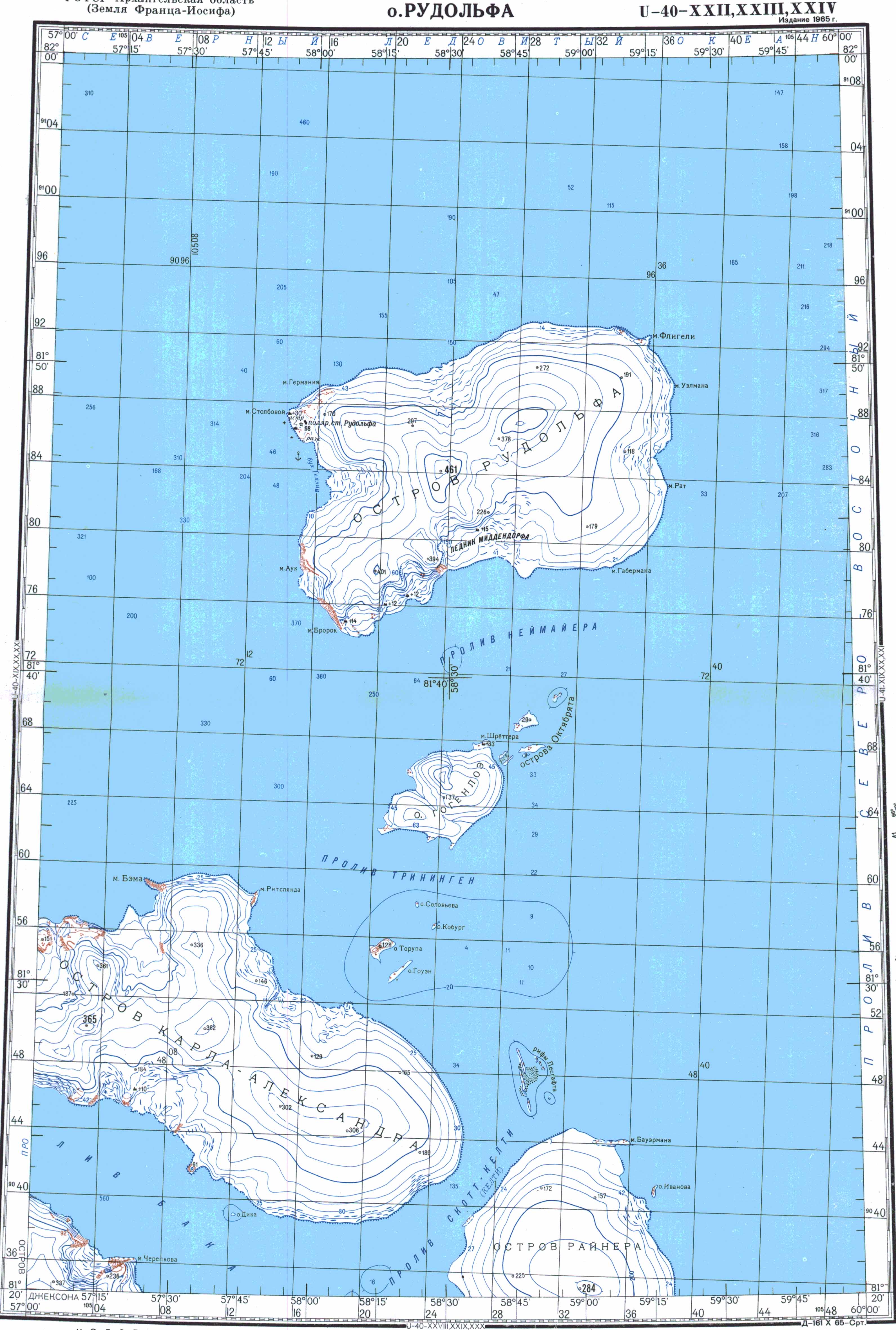
The Karl-Alexander Island ( Russian Остров Карла Александра- ; Ostrow Karla Alexandra ), and Karl Alexander Land ( Russian Земля Карла Александра- ; Zemlya Karla Alexandra ), is an island of the Arctic Franz Josef country . Administratively, it belongs to the Russian Arkhangelsk Oblast .
geography
The Karl Alexander Island is 29 km long and up to 18 km wide. Their area is about 329 km². Its highest point is in the west and measures 365 m . The Karl-Alexander-Insel is completely glaciated with the exception of a few shoreline zones, especially at Cape Felder (Mys Feldera) . The ice cap that covers the entire east is named after the Russian-Soviet polar explorer Rudolf Samoilowitsch . There are some small islands just off the coast: Torup Island, Houen Island and Coburg Island in the northeast and the Chichagov and Pontremoli Islands in the west. To the east, Karl Alexander Island is separated from Rainer Island by the 3 km wide Scott Keltie Sound , and to the south by the 6 km wide Back Canal from Jackson Island .
history
The Karl-Alexander-Insel was discovered during the Austro-Hungarian North Polar Expedition (1872–1874) and named after Karl Alexander von Sachsen-Weimar-Eisenach , a financier of the expedition. Julius Payer rested on 14./15. April 1874 on his second sleigh trip to the nearby Coburg Island. In 1895, Fridtjof Nansen and Fredrik Hjalmar Johansen circled the north of Karl Alexander Island on a Fram expedition and continued their way south on the west coast of the island. The island was mapped more precisely by the expedition with the Stella Polare under the direction of Luigi Amadeo of Savoy , who visited Franz Josef Land in 1899/1900 and made an advance to the North Pole from here .
Individual evidence
- ↑ UNEP Islands (English)
- ↑ Topographic map U-40-XXII, XXIII, XXIV (scale 1: 200,000)
- ^ Johan Schimanski, Ulrike Spring: Passengers of the Ice: Polar Heroes and Arctic Discourses 1874 . Böhlau, Vienna 2015, ISBN 978-3-205-79606-0 , p. 443 ( limited preview in the Google book search)
- ↑ a b Andreas Umbreit: Karl Alexander Insel - Franz-Joseph-Land on the website www.franz-josef-land.info , accessed on October 1, 2017
- ^ Julius Payer: The Austro-Hungarian North Pole Expedition in the years 1872–1874 , Alfred Hölder, Vienna 1876. P. 343 f.
- ↑ Fridtjof Nansen: In night and ice . Second volume, Brockhaus, Leipzig 1897. pp. 203 ff.
Aagaard Island | Adelaide Island | Alexandraland | Alger Island | Apollo Island | Arthur Island | Becker Island | Bell Island | Berghaus Island | Bliss Island | Borisjak Island | Brady Island | Brooch Island | Brice Island | Bromwich Island | Brown Islands | Bruce Island | Champ Island | Coburg Island | David Island | Davis Island | Derevyanny Island | Dicks Island | Eaton Island | Etheridge Islands | Elizabeth Island | Eva Liv Island | Freeden Island | Geddes Island | Gorbunow Island | Graham Bell Island | Greely Island | Hall Island | Harley Island | Hayes Island | Hochstetter Islands | Hoffmann Island | Hohenlohe Island | Hooker Island | Houen Island | Ivanov Island | Jackson Island | Jefferson Island | Kane Island | Karl Alexander Island | Klagenfurt Island | Kling Island | Bud Island | Koettlitz Island | Koldewey Island | Komsomol Islands | Kupolok Island | Kuchin Islands | Kuhn Island | La Ronciere Island | Lamont Island | Leigh Smith Island | Levanewski Island | Luigi Island | Luetke Island | Mabel Island | MacGee Islands | May Island | Maly Island | Marley Island | Mathilda Island | McClintock Island | McNulty Island | Nansen Island | Newcomb Island | Newton Island | Nitsch Island | Northbrook Island | Nowy Island | Ommanney Island | Payer Island | Mother-of-Pearl Island | Pontremoli Islands | Prince Georg Land | Querini island | Rainer Island | Robinson Island | Royal Society Island | Rudolf Island | Salisbury Island | Salm Island | Schönau Island | Scott Keltie Island | Solovyov Island | Stoliczka Island | Sub-island | Tillo Island | Torup Island | Tom Island | Trjochluchewoi Island | Chichagov Islands | Udachny Island | Ugolnoi Kopi Island | Weyprecht Island | Windward Island | Wiener Neustadt Island | Wilczek Island | Wilczek-Land | Ziegler Island