Northbrook Island
| Northbrook Island | ||
|---|---|---|
| Map of the Franz Josef Land | ||
| Waters | Barents Sea | |
| Archipelago | Franz Josef Land | |
| Geographical location | 80 ° 0 ′ N , 50 ° 53 ′ E | |
|
|
||
| length | 22.4 km | |
| width | 19.2 km | |
| surface | 288.6 km² | |
| Highest elevation | 344 m | |
| Location in the Franz-Josef-Land | ||
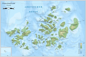
The Northbrook Island ( Russian Остров Нортбрук , Ostrow Nortbruk ) is one of the southernmost and best accessible from sea islands of the Franz Josef Land in the Arctic Ocean, which belongs to Russia . It was therefore the starting point for numerous polar expeditions .
geography
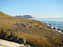
Northbrook Island is located at 80 degrees north latitude and is one of the smaller islands in Franz Josef Land. Their area was given in 1998 with just under 289 km². Since then, however, larger parts of its ice cap have melted, and the area around Cape Flora, which has been called Yuri-Kuchiev Island since 2008, is separated from the rest of the island by a shallow sound. Northbrook Island is nearly triangular in shape with sides about 25 km long; its highest point is given as 344 meters above sea level. But it is still mostly glaciated. Only some coastal strips are free of snow in summer.
history
The island was probably sighted as early as 1879 by a Dutch expedition led by A. de Bruyne from the Willem Barents , but without approaching the island.
The discovery of the island on August 14, 1880 by the British polar explorer Benjamin Leigh Smith on his fourth polar voyage is considered certain . It was named after Thomas Baring, 1st Earl of Northbrook (1826-1904), a British politician and later President of the Royal Geographical Society . On August 21, 1881, Smith stranded during his fifth and last polar voyage at Cape Flora in the extreme southwest of the island, but was able to save himself with dinghies to Novaya Zemlya .
On June 17, 1896, also at Cape Flora, the Norwegian polar explorer Fridtjof Nansen met the base camp of the Jackson Harmsworth expedition led by the British polar explorer Frederick George Jackson after his failed attempt to reach the North Pole . The northern tip of the island, Cape Bruce , was named after William Speirs Bruce , who participated in this expedition.
Some participants in the Fiala-Ziegler expedition had to winter on the island from 1904 to 1905 after their ship America sank near Rudolf Island .
In 1914, the month-long odyssey of the two only survivors of the Russian Brusilov expedition started in 1912 , navigator Valerian Albanow and sailor Alexander Konrad, ended at Cape Flora . They were found and rescued during another polar expedition led by Georgi Jakowlewitsch Sedov .
Web links
- Detailed information about Northbrook Island , with numerous pictures
Individual evidence
- ↑ a b UNEP Islands (English)
- ↑ Юлия Гальченкова: Парк во льдах . In: Наука и жизнь , January 24, 2012, accessed July 7, 2017 (Russian).
- ↑ Northbrook Island (О. Нортбрука, O. Nortbruk), Cape Flora on the website www.franz-josef-land.info , accessed on July 7, 2017.
- ↑ Leigh Smith Expeditions on board the Eira 1880, 1881-82 (English)
- ↑ Frederick George Jackson's biography ( memento of the original from October 3, 2008 in the Internet Archive ) Info: The archive link was automatically inserted and has not yet been checked. Please check the original and archive link according to the instructions and then remove this notice. (English)
- ^ Chronicle of the Franz-Joseph-Land - Fiala-Ziegler Expedition


