
Koldewey Island
| Koldewey Island | ||
|---|---|---|
 |
||
| Waters | Arctic Ocean | |
| Archipelago | Franz Josef Land | |
| Geographical location | 80 ° 8 ′ 0 ″ N , 59 ° 9 ′ 21 ″ E | |
|
||
| length | 4.5 km | |
| width | 3 km | |
| surface | 6.67 km² | |
| Highest elevation | Carl-Christian 66 m |
|
| Residents | uninhabited | |

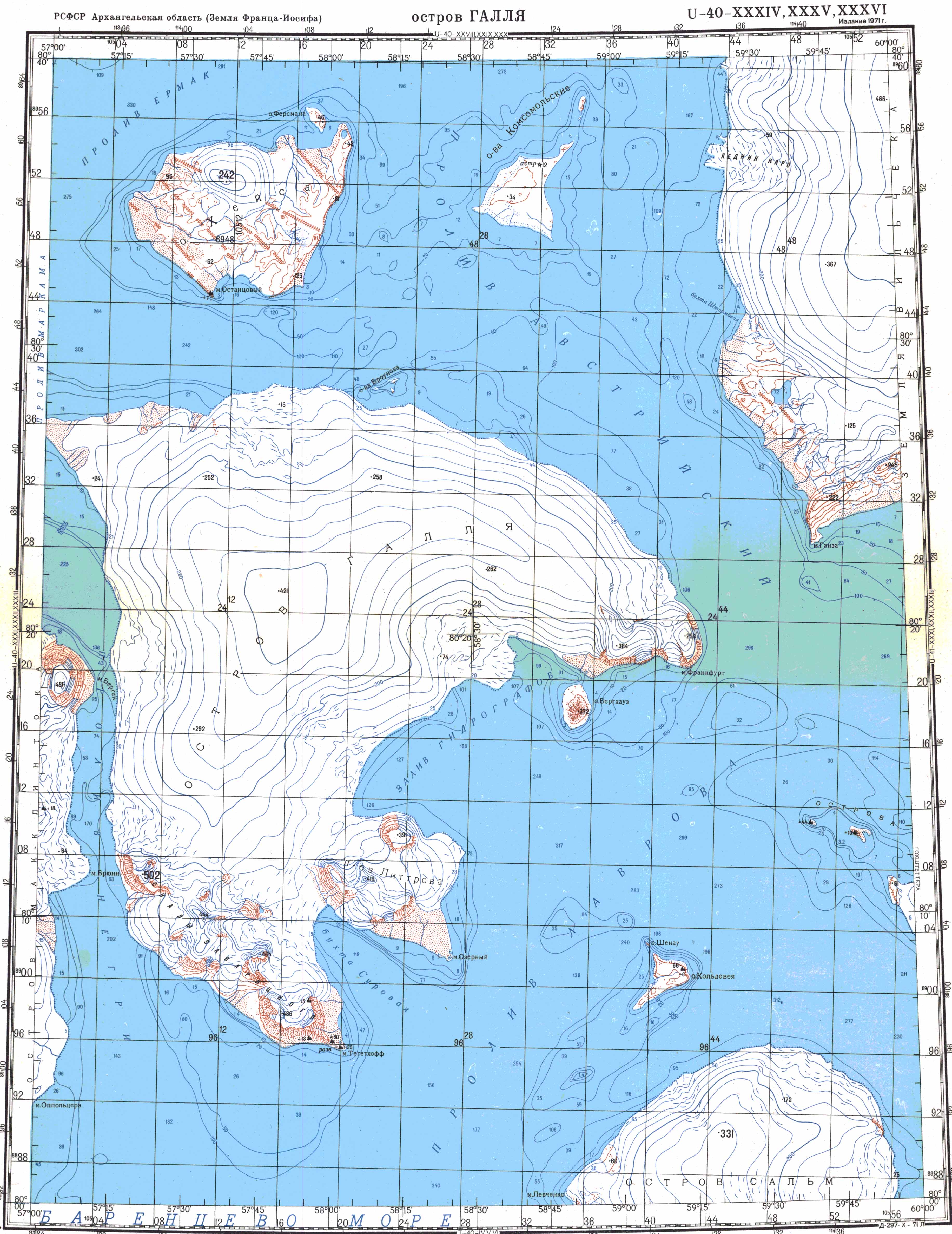
The Koldewey Island ( Russian остров Кольдевея , Ostrow Koldeweja ) is an island in the south of the Franz Josef Land in the Arctic Ocean, which belongs to Russia .
geography
The island belongs to the southeastern group of the archipelago and is relatively flat at 66 m compared to its larger neighbors, the Salm , Hall and Hochstetter islands . The island has no standing water. In summer, however, a stream flows from east to west through the main valley of the island. To the northwest, a steep promontory juts out into Lavrov Street . In front of it is the small Schönau Island, characterized by its rugged column structure . To the southwest, a long, flat cape merges into an undersea ridge, which stretches for another 12 kilometers to a shoal, the highest point of which is less than two meters below sea level. The 5.5 km wide strait between Koldewey Island and Salm Island, on the other hand, is around 200 m deep.
Unlike Salm Island, which is almost completely covered by an ice cap , Koldewey Island is not glaciated . Since June 15, 2009, like the entire Franz Josef Land archipelago, it has been part of the “Russian Arctic” National Park .
history
The island was discovered in 1874 by the Austro-Hungarian North Pole Expedition led by Carl Weyprecht and Julius Payer . Payer, who took part in the Second German North Pole Expedition to East Greenland in 1869/70 , named it after its leader, Carl Koldewey . On March 29, 1874, he climbed the highest mountain on the island to map the area. The expedition members met a polar bear who had her winter cave in a snow slope below the rock.
literature
- Julius Payer: The Austro-Hungarian North Pole Expedition in the years 1872–1874, together with a sketch of the second German North Pole expedition 1869–1870 and the polar expedition of 1871 , Alfred Hölder, Vienna 1876.
Web links
- Topographic map U-40-XXXIV, XXXV, XXXVI (scale 1: 200,000)

Aagaard Island | Adelaide Island | Alexandraland | Alger Island | Apollo Island | Arthur Island | Becker Island | Bell Island | Berghaus Island | Bliss Island | Borisjak Island | Brady Island | Brooch Island | Brice Island | Bromwich Island | Brown Islands | Bruce Island | Champ Island | Coburg Island | David Island | Davis Island | Derevyanny Island | Dicks Island | Eaton Island | Etheridge Islands | Elizabeth Island | Eva Liv Island | Freeden Island | Geddes Island | Gorbunow Island | Graham Bell Island | Greely Island | Hall Island | Harley Island | Hayes Island | Hochstetter Islands | Hoffmann Island | Hohenlohe Island | Hooker Island | Houen Island | Ivanov Island | Jackson Island | Jefferson Island | Kane Island | Karl Alexander Island | Klagenfurt Island | Kling Island | Bud Island | Koettlitz Island | Koldewey Island | Komsomol Islands | Kupolok Island | Kuchin Islands | Kuhn Island | La Ronciere Island | Lamont Island | Leigh Smith Island | Levanewski Island | Luigi Island | Luetke Island | Mabel Island | MacGee Islands | May Island | Maly Island | Marley Island | Mathilda Island | McClintock Island | McNulty Island | Nansen Island | Newcomb Island | Newton Island | Nitsch Island | Northbrook Island | Nowy Island | Ommanney Island | Payer Island | Mother-of-Pearl Island | Pontremoli Islands | Prince Georg Land | Querini island | Rainer Island | Robinson Island | Royal Society Island | Rudolf Island | Salisbury Island | Salm Island | Schönau Island | Scott Keltie Island | Solovyov Island | Stoliczka Island | Sub-island | Tillo Island | Torup Island | Tom Island | Trjochluchewoi Island | Chichagov Islands | Udachny Island | Ugolnoi Kopi Island | Weyprecht Island | Windward Island | Wiener Neustadt Island | Wilczek Island | Wilczek-Land | Ziegler Island