Prince Georg Land
| Prince Georg Land | ||
|---|---|---|
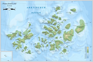
| Map of the Franz Josef Land | ||
| Waters | Arctic Ocean | |
| Archipelago | Franz Josef Land | |
| Geographical location | 80 ° 30 ′ N , 49 ° 0 ′ E | |
|
|
||
| length | 116 km | |
| width | 43 km | |
| surface | 2 821 km² | |
| Highest elevation | Brusilov ice cap 416 m |
|
| Residents | uninhabited | |
The Prince Georg Land ( Russian Земля Георга , Semlja Georga ) is an uninhabited island in the Franz Josef Land in the Arctic Ocean, which belongs to Russia .
geography
With a length of 116 km and an area of around 2821 km², Prinz-Georg-Land is the longest and largest island in Franz-Josef-Land; its highest point is the northern ice cap at 416 meters above sea level. It is separated from Arthur Island to the north by the Leigh Smith Canal and from Alexandraland , the westernmost island in the archipelago, by the Cambridge Canal . Prinz-Georg-Land is largely covered by ice, its coastline has numerous bays and fjords .
In the north lies the large, largely unglaciated Armitage Peninsula ( Poluostrow Armitidsch ) .
history
Prince George Land was first spotted in August 1880 by the British polar explorer Benjamin Leigh Smith on his fourth polar voyage. An in-depth exploration was carried out in 1897 by the Jackson-Harmsworth Expedition under the direction of Frederick George Jackson . He named the island in honor of George Frederick Ernest Albert von Sachsen-Coburg and Gotha, Prince of Wales, the later British King George V.
Individual evidence
- ↑ UNEP Islands (English)
- ↑ Prince George Country in franz-josef-land.info


