
Hoffmann Island
| Hoffmann Island | ||
|---|---|---|
 |
||
| Waters | Arctic Ocean | |
| Archipelago | Franz Josef Land | |
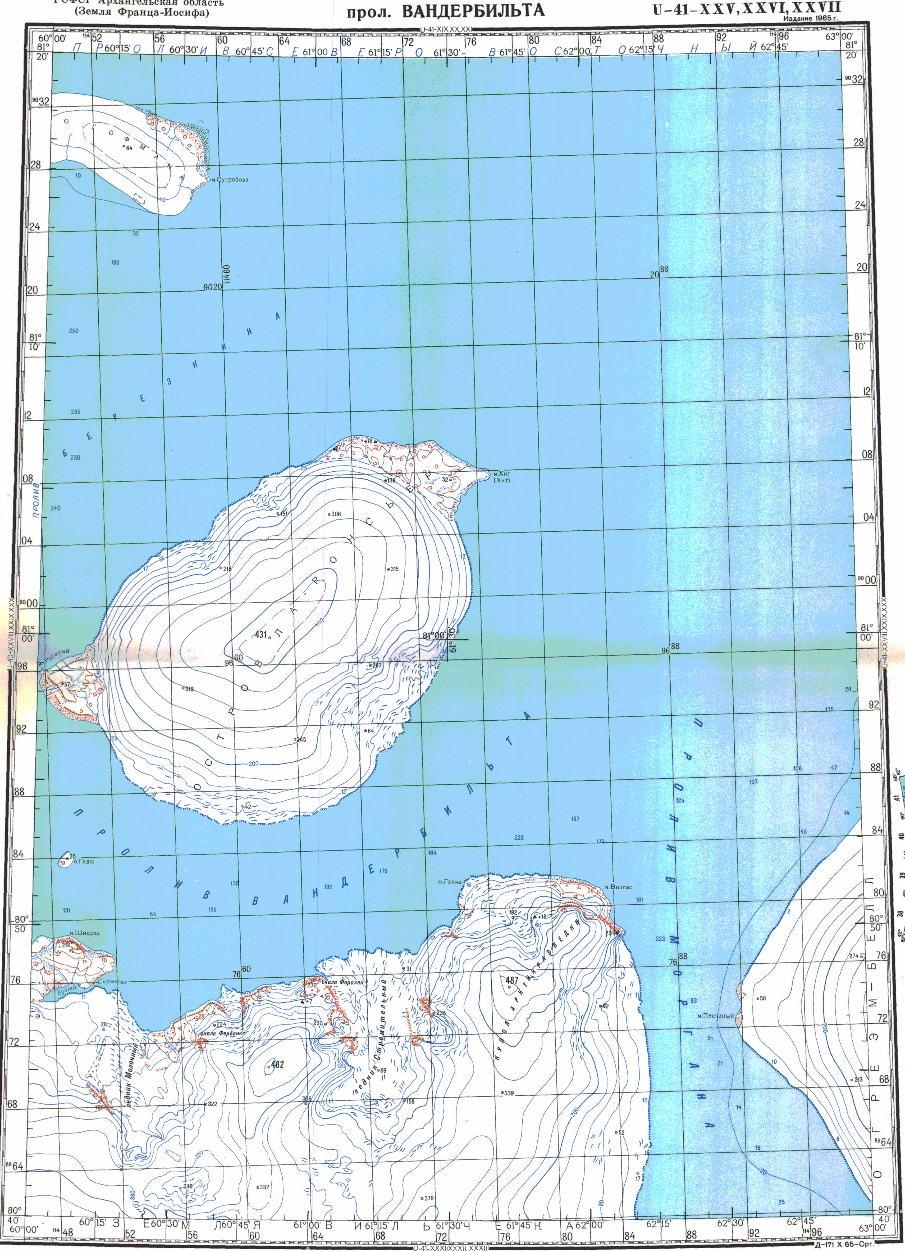
| Geographical location | 81 ° 17 ′ N , 60 ° 12 ′ E | |
|
||
| length | 13 km | |
| width | 5.6 km | |
| surface | 49 km² | |
| Highest elevation | 64 m | |
| Residents | uninhabited | |
 |
||

The Hoffmann Island ( Russian Остров Гофмана , Ostrov Gofmana , partly as Hofmann Island known) is an uninhabited island of the Franz-Josef-Lands , Arkhangelsk Oblast , Russia . It was named after Freiherr Leopold von Hoffmann , a member of the Austro-Hungarian North Pole Society.
geography
The Hoffmann Island has an area of approx. 49 km², a length of 13 km and a maximum width of 5.6 km. It is located about 9 km east of the Rainer Island , from which it is separated by the Ruslan Strait ( Proliw Ruslan ). Three small islets lie off its northeastern coast. A 45 km wide canal, known as Proliw Severo Vostotschny , runs northeast of Hoffmann Island , on the opposite side of which is Freeden Island . Its highest point is 64 m .
Web links
- Topographic map U40-XXVIII-IXXX-XXX on a scale of 1: 200,000
Individual evidence
- ^ Günther Hamann : The age of Emperor Franz Josef as reflected in the topography of the Franz Josef Land . In: Publications from the archive of the University of Graz . Volume 4, 1975, pp. 139–151, here: p. 146 ( limited preview in Google book search)
- ^ Johan Schimanski, Ulrike Spring: Passengers of the Ice: Polar Heroes and Arctic Discourses 1874 . Böhlau Verlag, Vienna 2015, ISBN 978-3-205-79606-0 , p. 102 ( limited preview in Google Book search).
- ↑ a b c d Measurement of length, width and area via Google Maps
- ↑ Topographic map U41-XXV-XXVI-XXVII on a scale of 1: 200,000
Aagaard Island | Adelaide Island | Alexandraland | Alger Island | Apollo Island | Arthur Island | Becker Island | Bell Island | Berghaus Island | Bliss Island | Borisjak Island | Brady Island | Brooch Island | Brice Island | Bromwich Island | Brown Islands | Bruce Island | Champ Island | Coburg Island | David Island | Davis Island | Derevyanny Island | Dicks Island | Eaton Island | Etheridge Islands | Elizabeth Island | Eva Liv Island | Freeden Island | Geddes Island | Gorbunow Island | Graham Bell Island | Greely Island | Hall Island | Harley Island | Hayes Island | Hochstetter Islands | Hoffmann Island | Hohenlohe Island | Hooker Island | Houen Island | Ivanov Island | Jackson Island | Jefferson Island | Kane Island | Karl Alexander Island | Klagenfurt Island | Kling Island | Bud Island | Koettlitz Island | Koldewey Island | Komsomol Islands | Kupolok Island | Kuchin Islands | Kuhn Island | La Ronciere Island | Lamont Island | Leigh Smith Island | Levanewski Island | Luigi Island | Luetke Island | Mabel Island | MacGee Islands | May Island | Maly Island | Marley Island | Mathilda Island | McClintock Island | McNulty Island | Nansen Island | Newcomb Island | Newton Island | Nitsch Island | Northbrook Island | Nowy Island | Ommanney Island | Payer Island | Mother-of-Pearl Island | Pontremoli Islands | Prince Georg Land | Querini island | Rainer Island | Robinson Island | Royal Society Island | Rudolf Island | Salisbury Island | Salm Island | Schönau Island | Scott Keltie Island | Solovyov Island | Stoliczka Island | Sub-island | Tillo Island | Torup Island | Tom Island | Trjochluchewoi Island | Chichagov Islands | Udachny Island | Ugolnoi Kopi Island | Weyprecht Island | Windward Island | Wiener Neustadt Island | Wilczek Island | Wilczek-Land | Ziegler Island