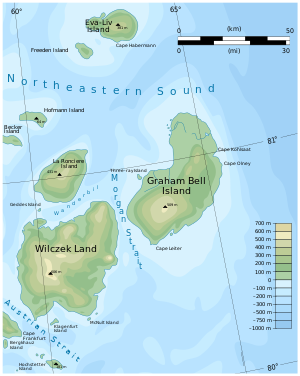
Eva Liv Island
| Eva Liv Island | ||
|---|---|---|
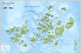
| The east of Franz Josef Land with Eva Liv Island | ||
| Waters | Arctic Ocean | |
| Archipelago | Franz Josef Land | |
| Geographical location | 81 ° 38 ′ N , 63 ° 6 ′ E | |
|
|
||
| length | 28 km | |
| surface | 288 km² | |
| Highest elevation | Vostok 4 (ice cap) 381 m |
|
| Residents | uninhabited | |
| Location of Eva Liv Island | ||
The Eva Liv Island ( Russian Остров Ева-Лив , Ostrow Jewa-Liw ) is an uninhabited island in the arctic Franz Josef Land, which belongs to Russia .
It is the largest of a group of islands in the northeast of the archipelago, which also includes Freeden Island and Adelaide Island . In Russian they are called White Land ( Белая Земля ), a designation that goes back to Fridtjof Nansen , who found solid land here for the first time after his advance towards the North Pole in 1895 and named it because of its heavy glaciation ( Norwegian Hvidtenland ).
Eva Liv Island has an area of 288 km² and a length of 28 km. It is almost completely covered by two ice caps . Nansen assumed they would be two separate islands, which he named after his wife Eva and their daughter Liv. Later it was believed to be dealing with only one island, which led to the current name. Due to the melting of the ice caps, a peninsula in the north has now turned out to be a separate island (Mesyazew Island, Остров Месяцева). It is quite possible that an Eve and a Liv island are hidden under the ice caps.
Individual evidence
- ^ Eva-Liv-Insel on the website www.franz-josef-land.info , accessed on June 9, 2011
Web links
- Topographic maps of the island: western part , eastern part


