
La Ronciere Island
| La Ronciere Island | ||
|---|---|---|
 |
||
| Waters | Arctic Ocean | |
| Archipelago | Franz Josef Land | |
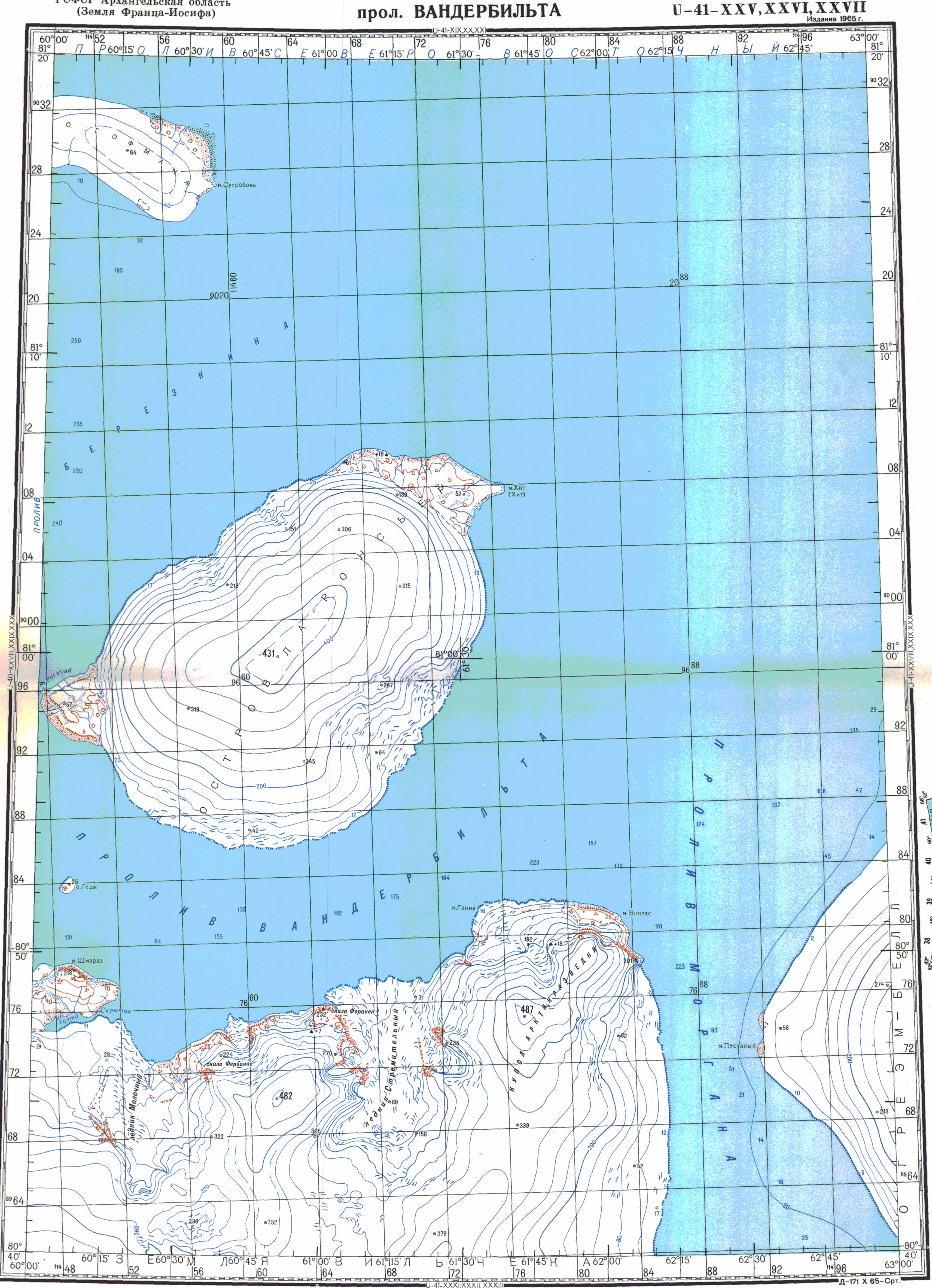
| Geographical location | 81 ° 0 ′ N , 60 ° 52 ′ E | |
|
||
| length | 29 km | |
| width | 19 km | |
| surface | 478 km² | |
| Highest elevation | 431 m | |
| Residents | uninhabited | |

The La Ronciere Island ( Russian Остров Ла-Ронсьер , Ostrow La-Ronsjer ) is an uninhabited island of the arctic Franz Josef Land belonging to Russia .
It lies in the east of the archipelago and is separated from the Wilczek Land to the south by the 10 km wide Vanderbilt Strait. Arthur Island is 478 km² and is covered by an ice cap up to 431 m high, except for the coastal region around Cape Hitt in the northeast and the western Cape Mys Rogaty .
The La Ronciere Island was discovered by the Austro-Hungarian North Polar Expedition (1872–1874) and considered a peninsula of Wilczek Land. Julius Payer named it after Camille de La Roncière-Le Noury (1816–1881), the president of the French Société de Géographie . Their island character only recognized Evelyn Briggs Baldwin , who drove a dog sled through Vanderbilt Street during the Walter Wellman Expedition (1898–1899) . Wellman's naming of the island after William Collins Whitney , a financier of his expedition, did not last.
Individual evidence
- ↑ LaRonciere Insel on the website www.franz-josef-land.info , accessed on July 4, 2017.
- ↑ Peter J. Capelotti: EB Baldwin and the American-Norwegian discovery and exploration of Graham Bell Island, 1899 . In: Polar Research . Volume 25, No. 2, 2006, pp. 155-171. doi : 10.3402 / polar.v25i2.6245
- ^ Peter J. Capelotti: The Greatest Show in the Arctic: The American Exploration of Franz Josef Land, 1898–1905 . University of Oklahoma Press, Norman (Oklahoma) 2016, ISBN 978-0-8061-5222-6 , pp. 185 (English, limited preview in Google Book Search).
Web links
- Topographic map of the island at a scale of 1: 200,000

Aagaard Island | Adelaide Island | Alexandraland | Alger Island | Apollo Island | Arthur Island | Becker Island | Bell Island | Berghaus Island | Bliss Island | Borisjak Island | Brady Island | Brooch Island | Brice Island | Bromwich Island | Brown Islands | Bruce Island | Champ Island | Coburg Island | David Island | Davis Island | Derevyanny Island | Dicks Island | Eaton Island | Etheridge Islands | Elizabeth Island | Eva Liv Island | Freeden Island | Geddes Island | Gorbunow Island | Graham Bell Island | Greely Island | Hall Island | Harley Island | Hayes Island | Hochstetter Islands | Hoffmann Island | Hohenlohe Island | Hooker Island | Houen Island | Ivanov Island | Jackson Island | Jefferson Island | Kane Island | Karl Alexander Island | Klagenfurt Island | Kling Island | Bud Island | Koettlitz Island | Koldewey Island | Komsomol Islands | Kupolok Island | Kuchin Islands | Kuhn Island | La Ronciere Island | Lamont Island | Leigh Smith Island | Levanewski Island | Luigi Island | Luetke Island | Mabel Island | MacGee Islands | May Island | Maly Island | Marley Island | Mathilda Island | McClintock Island | McNulty Island | Nansen Island | Newcomb Island | Newton Island | Nitsch Island | Northbrook Island | Nowy Island | Ommanney Island | Payer Island | Mother-of-Pearl Island | Pontremoli Islands | Prince Georg Land | Querini island | Rainer Island | Robinson Island | Royal Society Island | Rudolf Island | Salisbury Island | Salm Island | Schönau Island | Scott Keltie Island | Solovyov Island | Stoliczka Island | Sub-island | Tillo Island | Torup Island | Tom Island | Trjochluchewoi Island | Chichagov Islands | Udachny Island | Ugolnoi Kopi Island | Weyprecht Island | Windward Island | Wiener Neustadt Island | Wilczek Island | Wilczek-Land | Ziegler Island