
Rudolf Island
| Rudolf Island | ||
|---|---|---|
 |
||
| Waters | Arctic Ocean | |
| Archipelago | Franz Josef Land | |
| Geographical location | 81 ° 46 ′ N , 58 ° 56 ′ E | |
|
||
| length | 25.4 km | |
| width | 15.1 km | |
| surface | 297 km² | |
| Highest elevation | 461 m | |
| Residents | uninhabited | |
 |
||

The Rudolf Island ( Russian остров Рудольфа , Ostrow Rudolfa) is the northernmost island of the Franz Josef Land and with 297 km² and rank 16 one of the larger islands of the archipelago. It was discovered during the Austro-Hungarian North Pole Expedition (1872–1874) and originally named after Crown Prince Rudolf of Austria-Hungary by Julius Payer, Crown Prince Rudolph Land . On the island is Cape Fligely, the northernmost land point of Eurasia.
The island was the starting point for pole expeditions at the end of the 19th and beginning of the 20th century (Teplitz Bay). The Russian polar explorer Georgi Jakowlewitsch Sedov died in 1914 near Rudolf Island and was buried on it.
Cape Fligely
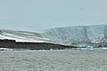
The tip of the cape protruding from the surrounding ice cap of Rudolf Island into the polar sea represents the northernmost point of land in Eurasia.

Cape Fligely: Northern tip of Rudolf Island, northernmost headland of Eurasia (81 ° 50'35``N, 59 ° 14'22''E)

Cape Fligely (Rudolf Island, Franz Josef Land)

Cape Fligely (Rudolf Island)

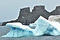
Rudolf Island: Glacier at Cape Fligely


Polar station
In the summer of 1932, as part of the Second International Polar Year, a weather station was set up in the west of the island on Cape Stolbowoi north of Teplitz Bay. Four people under NF Balabin spent the winter there. After a temporary closure, the station was again in operation from summer 1936 to 1995 (with a war-related interruption from April 1942 to 1947). In 1937 the station served as the base for the North Pole expedition under Papanin . As part of this, landing runways for the Tupolev ANT 6 aircraft used by the expedition were set up near the station and on the ice dome .

Cape Stolbowoi (northwest corner of Rudolf Island; 81 ° 45'22``N, 57 ° 57'32''E)
Cape Stolbowoi

Cape Stolbowoi

Teplitz Bay near Cape Stolbowoi with the remains of the polar station

Teplitz Bay
Teplitz Bay


literature
- Judith Schalansky : Atlas of the remote islands . Fifty islands that I have never been and will never be , Mare, Hamburg 2009, ISBN 978-3-86648-117-6 .
- EI Alexandrov: Climatic regime and its changes in the region of the Barents and Kara seas (PDF; 463 kB), Russian Federation Arctic and Antarctic Research Institute, 2000, u. a. Weather data diagrams for Rudolf Island
- List of Russian Arctic Stations , Russian Federation the Arctic and Antarctic Research Institute (Russian)
Web links
- Map of the northeastern Franz Josef Land with Rudolf Island , 1: 200,000
- Map of Franz Josef Land with Rudolf Island , 1: 1,000,000
- Photos of buildings on the island on Flickr
Aagaard Island | Adelaide Island | Alexandraland | Alger Island | Apollo Island | Arthur Island | Becker Island | Bell Island | Berghaus Island | Bliss Island | Borisjak Island | Brady Island | Brooch Island | Brice Island | Bromwich Island | Brown Islands | Bruce Island | Champ Island | Coburg Island | David Island | Davis Island | Derevyanny Island | Dicks Island | Eaton Island | Etheridge Islands | Elizabeth Island | Eva Liv Island | Freeden Island | Geddes Island | Gorbunow Island | Graham Bell Island | Greely Island | Hall Island | Harley Island | Hayes Island | Hochstetter Islands | Hoffmann Island | Hohenlohe Island | Hooker Island | Houen Island | Ivanov Island | Jackson Island | Jefferson Island | Kane Island | Karl Alexander Island | Klagenfurt Island | Kling Island | Bud Island | Koettlitz Island | Koldewey Island | Komsomol Islands | Kupolok Island | Kuchin Islands | Kuhn Island | La Ronciere Island | Lamont Island | Leigh Smith Island | Levanewski Island | Luigi Island | Luetke Island | Mabel Island | MacGee Islands | May Island | Maly Island | Marley Island | Mathilda Island | McClintock Island | McNulty Island | Nansen Island | Newcomb Island | Newton Island | Nitsch Island | Northbrook Island | Nowy Island | Ommanney Island | Payer Island | Mother-of-Pearl Island | Pontremoli Islands | Prince Georg Land | Querini island | Rainer Island | Robinson Island | Royal Society Island | Rudolf Island | Salisbury Island | Salm Island | Schönau Island | Scott Keltie Island | Solovyov Island | Stoliczka Island | Sub-island | Tillo Island | Torup Island | Tom Island | Trjochluchewoi Island | Chichagov Islands | Udachny Island | Ugolnoi Kopi Island | Weyprecht Island | Windward Island | Wiener Neustadt Island | Wilczek Island | Wilczek-Land | Ziegler Island