Hohenlohe Island
| Hohenlohe Island | ||
|---|---|---|
| Map of the Franz Josef Land | ||
| Waters | Arctic Ocean | |
| Archipelago | Franz Josef Land | |
| Geographical location | 81 ° 36'30 " N , 58 ° 31'0" E | |
|
|
||
| length | 8 kilometers | |
| surface | 38 km² | |
| Highest elevation | 137 m | |
| Residents | uninhabited | |
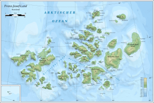
The Hohenlohe Island ( Russian остров Гогенлоэ , Ostrow Gogenloe ) is an uninhabited island in the arctic Franz Josef Land, which belongs to Russia .
It is separated from Rudolf Island , the northernmost island of the archipelago , by the Neumayer Sound, which is around 10 km wide. The Karl-Alexander-Insel is about 10 km to the southwest . The Oktjabrjata rocky cliffs ( Острова Октябрята ) are located northeast of Hohenlohe Island .
With a length of around eight kilometers and an area of 38 km², Hohenlohe Island is one of the smaller of the archipelago. It is almost completely covered by two flat ice caps that merge into one another and reach a height of around 200 m. Some rocky capes protrude from the ice sheet, especially the striking Cape Schrötter in the north, named after Anton Schrötter von Kristelli .
The island was discovered during the Austro-Hungarian north polar expedition in April 1874 and named by Julius Payer after the Franconian noble family Hohenlohe . Leaving his exhausted crew behind at Cape Schrötter, Payer and two companions reached Rudolf Island and the end point of his expedition, Cape Fligely . The Payer-Weyprecht memorial expedition , which followed in Payer's footsteps, ended in May 2005 at Cape Schrötter.
literature
- Julius Payer: The Austro-Hungarian North Pole Expedition in the years 1872–1874 . Hölder, Vienna 1876. ( PDF file, 23 MB )
Web links
- Topographic map of the northeastern Franz Josef Land with Hohenlohe Island, 1: 200,000
- Hohenlohe-Insel on the website www.franz-josef-land.info


