Ziegler Island
| Ziegler Island | ||
|---|---|---|
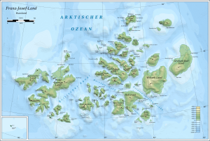
| Map of the Franz Josef Land | ||
| Waters | Arctic Ocean | |
| Archipelago | Franz Josef Land | |
| Geographical location | 81 ° 0 ′ N , 57 ° 15 ′ E | |
|
|
||
| length | 45 km | |
| width | 15 km | |
| surface | 448 km² | |
| Highest elevation | 554 m | |
| Residents | uninhabited | |
| Location of the Ziegler island in the center of the red-colored area | ||
The Ziegler Island ( Russian Остров Циглера ) is an uninhabited island in the arctic Franz Josef Land, which belongs to Russia .
geography
With an area of 448 km², the island is the eleventh largest in the archipelago. Its interior is almost completely covered with ice. The Ziegler Island is separated from its neighbors by straits that are only a few kilometers wide.
history
The south of the island was already sighted by the Austro-Hungarian North Pole Expedition in spring 1874. Julius von Payer considered them and their neighboring islands to be parts of a larger land mass, which he named "Zichy-Land" after a sponsor of his expedition. It was not until the Fiala-Ziegler Expedition 1903–1905 that the island's independence was recognized and mapped. It was named after the sponsor of this expedition, William Ziegler (1843–1905).
Individual evidence
Web links
- Ziegler Island on the website www.franz-josef-land.info


