Hayes Island
| Hayes Island | ||
|---|---|---|
| Map of the Franz Josef Land | ||
| Waters | Arctic Ocean | |
| Archipelago | Franz Josef Land | |
| Geographical location | 80 ° 35 ' N , 57 ° 42' E | |
|
|
||
| length | 16 km | |
| width | 10 km | |
| surface | 132 km² | |
| Highest elevation | Hydrograph ice cap (Kupol Gidrografow) 242 m |
|
| Residents | 4 ward staff (winter) (2007) <1 inh / km² |
|
| main place | Geophysical Observatory ET Krenkel | |
| Location of Hayes Island | ||
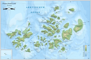
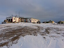
The Hayes Island ( Russian остров Хейса / Ostrow Chjejsa , English Hayes Island or Heiss Island ) is an island of the Franz Josef Land archipelago belonging to Russia . In the northeast of the island is the geophysical observatory ET Krenkel , one of the two Russian polar stations on Franz Josef Land.
geography
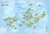
With an area of 132 km², Hayes Island is one of the smaller Franz Josef Lands. It is located in the middle of the archipelago north of Hall Island and southeast of Champ and Salisbury Island . In the northeast lies the Wiener Neustadt Island and in the east the Wilczek Island . To the north is the small Fersman Island. Markham Sound meets Austriasund on Hayes Island .
Hayes Island is relatively flat and ice-free, with the exception of an ice cap about five kilometers in diameter on the north coast . The south coast is characterized by basalt cliffs . Most of the island is covered by sedimentary deposits from the Cretaceous and Jurassic . Several dolerite - Dykes criss-cross the island from the southeast to the northwest. In between there are meltwater streams. In the far northeast is a volcanic crater lake .
climate
There is a maritime arctic climate on Hayes Island . The mean annual temperature is −12 ° C. Only July has a mean temperature above freezing point. It is often foggy in the summer months. The mean air humidity is over 80% all year round and over 90% in the summer months. Strong winds blow on the island all year round, in winter mainly from the east and in summer from the north-west.
|
Average monthly temperatures and rainfall for Krenkelstation, Hayes Island
Source: DA Walker et al .: 2010 Expedition to Krenkel Station, Hayes Island, Franz Josef Land, Russia (PDF; 9.1 MB), accessed on December 14, 2012 (English)
|
||||||||||||||||||||||||||||||||||||||||||||||||||||||||||||||||||||||||||||||||||||||||||||||||||||||||||||||||||||||||
Flora and fauna
Vegetation is sparse on Hayes Island. There are mainly lichens and mosses before. The most common vascular plant is the arctic poppy . On the island breeding eider ducks , sea beach runner , Arctic skuas , Arctic terns , snow buntings and ivory gulls . In addition, fulmars , red-throated divers , great skuas , spatula gulls , ice gulls , kittiwakes , crab grebes and black guillemots could also be observed.
history
The island was sighted by the Austro-Hungarian North Polar Expedition in 1874 , but Julius Payer thought it was a peninsula of Hall Island. In 1898 it was named by members of the Wellman expedition after the US polar explorer Isaac Israel Hayes .
A polar station has been located on Hayes Island since 1957. From 1965 it was expanded to become the largest weather observatory in the Arctic . At times, up to 200 scientists worked here. Between 1956 and 1990, 1,950 sounding rockets , such as the MR-12, were launched from the island .
In honor of the Russian polar explorer Ernst Theodorowitsch Krenkel , the station on Hayes Island was named Geophysical Observatory ET Krenkel in 1972 . In 2001 a fire destroyed the power supply facilities and some buildings. As part of the International Polar Year 2007/2008 , the research station on Hayes Island was rebuilt through a Russian-US cooperation.
Web links
- Photos ( Memento from April 5, 2012 in the Internet Archive )
Individual evidence
- ↑ UNEP Islands (English)
- ↑ Topographic map U-40-XXXIV, XXXV, XXXVI on a scale of 1: 200,000
- ↑ EA Slagoda et al .: permafrost in Hayes Iceland, Franz Josef Land Archipelago (PDF; 31.6 MB). In: Kriosfera Zemli . Volume 19, No. 4, 2015, pp. 17–28 (English)
- ↑ a b c d e f D. A. Walker et al .: 2010 Expedition to Krenkel Station, Hayes Island, Franz Josef Land, Russia (PDF; 9.1 MB), Data Report, Alaska Geobotany Center, Institute of Arctic Biology, University of Alaska Fairbanks, Fairbanks, AK 2011 (English)
- ↑ Meredith Williams, Julian A. Dowdeswell: Mapping seabird nesting habitats in Franz Josef Land, Russian High Arctic, using digital Landsat Thematic Mapper imagery ( Memento of the original from May 23, 2014 in the Internet Archive ) Info: The archive link was inserted automatically and still Not checked. Please check the original and archive link according to the instructions and then remove this notice. . In: POLAR 17, 1998, pp. 15–30 (English)
- ^ William James Mills: Exploring Polar Frontiers - A Historical Encyclopedia , Vol. 1, ABC-CLIO, 2003, ISBN 1-57607-422-6 , p. 290 (English)
- ↑ List of rocket launches from Hayes Island in Encyclopedia Astronautica , accessed on October 4, 2017.
- ↑ Andreas Umbreit: Hayes (Chejsa, Kheysa, Heiss) Insel - Krenkel Station - Franz-Joseph-Land on the website www.franz-josef-land.info , accessed on October 4, 2017
- ↑ FERMAP Franz Josef Land Environmental Research, Monitoring and Assessment Program (PDF; 460 kB; German)


