Champ Island
| Champ Island | ||
|---|---|---|
| Map of the Franz Josef Land | ||
| Waters | Arctic Ocean | |
| Archipelago | Franz Josef Land | |
| Geographical location | 80 ° 41 ′ N , 56 ° 21 ′ E | |
|
|
||
| length | 27 km | |
| width | 18 km | |
| surface | 374.3 km² | |
| Highest elevation | 507 m | |
| Residents | uninhabited | |
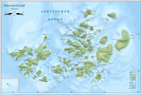
| Champ Island on a satellite photo (bottom left) | ||
The Champ Island ( Russian Чамп , Tschamp ) is an uninhabited island in the arctic Franz Josef Land, which belongs to Russia .
geography
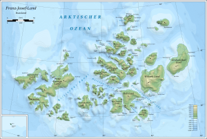
The 374 km² Champ Island is centrally located in the Franz Josef Land archipelago . It is the southernmost of a group of islands that are only separated from each other by narrow straits that are frozen almost all year round and were initially regarded as a contiguous land mass, Zichy Land . From the northern Salisbury Island , the Champ Island is separated only by the few hundred meters wide Pondorff-Enge, from the Luigi Island in the north-west by the Cook Strait. The Champ Island is heavily glaciated . More than 50% of its coastline consists of glacier edges.
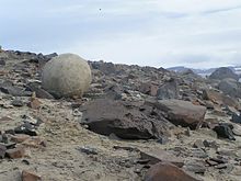
A geological peculiarity are the numerous concretions - stones that have formed around a central fossil . You can find them especially on the capes of the south coast, Cape Fiume and Cape Trieste. They come from the Upper Triassic and are often perfectly spherical with a diameter of up to three meters.
There are some colonies of sea birds on the south and west coasts . Kittiwakes and crab grebes breed here most often .
history
The southeast coast of the island between Cape Fiume and Cape Trieste was mapped in 1874 by the Austro-Hungarian North Pole Expedition (1872–1874) as part of Zichy Land , which was named after Count Ödön Zichy (1811–1894), one of the main sponsors of the expedition . It was not until the Fiala-Ziegler Expedition (1903–1905) that the island was identified as having a distinct character. Anthony Fiala (1869–1950) named it after William S. Champ, who saved the men in distress in 1905.
Individual evidence
- ↑ Friedhelm Thiedig: Journey to the Geographical North Pole and Franz Josef Land (2005) - with a description of the Klagenfurt Islands and the strikingly large stone spheres east of Cape Fiume on Champ Island (FJL). In: Carinthia II . 196/116 Volume, Klagenfurt 2006, pp. 9–32 ( PDF (11.2 MB) on ZOBODAT ).
- ↑ Meredith Williams, Julian A. Dowdeswell: Mapping seabird nesting habitats in Franz Josef Land, Russian High Arctic, using digital Landsat Thematic Mapper imagery . In: Polar Research . Volume 17, 1998, pp. 15-30 (English). doi : 10.3402 / polar.v17i1.6604 .
- ^ Anthony Fiala: Fighting the Polar Ice . Doubleday, Page & Co., New York 1907, p. 193 .
Web links
- Andreas Umbreit: Champ island, stone balls (geodes) - Franz-Joseph-Land on the Franz-Joseph-Land Info website


