Jackson Island
| Jackson Island | ||
|---|---|---|
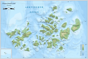
| Map of the Franz Josef Land | ||
| Waters | Arctic Ocean | |
| Archipelago | Franz Josef Land | |
| Geographical location | 81 ° 15 ′ N , 56 ° 54 ′ E | |
|
|
||
| length | 40 km | |
| width | 30 km | |
| surface | 521.4 km² | |
| Highest elevation | Vostok-5 ice cap 481 m |
|
| Residents | uninhabited | |
| Location of Jackson Island in the Franz Josef Land archipelago | ||
The Jackson Island ( Russian остров Джексона , Ostrow Dscheksona ) is an uninhabited island of the to Russia belonging Arctic Franz Josef Land .
geography
With an area of 521 km², the island is the eighth largest in the archipelago. Its interior is almost completely covered by ice. One of its two ice caps reaches a height of 481 m. De Long Bay cuts deep into the island from the northwest. Jackson Island is separated from its neighbors by 5–10 km wide straits: in the northeast by the Back Canal from Karl Alexander Island , in the southeast by the Italian Channel from Payer Island and in the south by the Booth- Canal from Ziegler Island . To the west there are several smaller islands and cliffs.
There are some nesting rocks for seabirds, especially in the west of Jackson Island . The grebe , black guillemot and the kittiwake are particularly well represented .
history
The island was first sighted by the Austro-Hungarian North Pole Expedition in spring 1874. Julius Payer mapped their eastern part around Cape Kremsmünster and believed them and their neighboring islands to be parts of a larger land mass, which he named Zichy-Land after a sponsor of his expedition. In 1895 the Jackson Harmsworth expedition reached the island and explored the southwest part to Cape Hugh Mill, the westernmost point of the island. From August 17, 1895 to May 19, 1896, Fridtjof Nansen and Hjalmar Johansen spent the winter under the most primitive conditions on Cape Norvegia. They had previously reached the northernmost point where humans had been before when they tried to dog sled from the ship Fram, which was drifting with the ice, to the North Pole. When Nansen found Frederick Jackson's camp at Cape Flora on Northbrook Island in 1896 and was able to return to Norway on his ship, he suggested naming the as yet unnamed island after his savior.
The northern part of Jackson Island was mapped in 1900 by the Duke of Abruzzo's expedition with the Stella Polare . In 1902 and 1904 the island was visited by further expeditions. Evelyn Baldwin recovered a note from 1896 deposited by Nansen and gave it to the Norwegian Embassy in Washington, DC 30 years later. It is now in the library of the University of Oslo .
Web links
- Jackson Island on the website www.franz-josef-land.info
Individual evidence
- ↑ UNEP Islands (English)
- ↑ Meredith Williams, Julian A. Dowdeswell: Mapping seabird nesting habitats in Franz Josef Land, Russian High Arctic, using digital Landsat Thematic Mapper imagery ( Memento of the original from May 23, 2014 in the Internet Archive ) Info: The archive link was inserted automatically and still Not checked. Please check the original and archive link according to the instructions and then remove this notice. . In: POLAR 17, 1998, pp. 15–30 (English)
- ^ PJ Capelotti: EB Baldwin and the American-Norwegian discovery and exploration of Graham Bell Island, 1899 . In: Polar Research . Volume 25, No. 2, 2006, pp. 155-171. doi : 10.3402 / polar.v25i2.6245
- ↑ WJ Mills: Exploring Polar Frontiers - A Historical Encyclopedia , Vol. 1, ABC-CLIO, 2003, ISBN 1-57607-422-6 , p. 331 (English)


