Wiener Neustadt Island
| Wiener Neustadt Island | ||
|---|---|---|
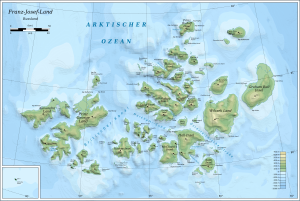
| Map of the Franz Josef Land | ||
| Waters | Arctic Ocean | |
| Archipelago | Franz Josef Land | |
| Geographical location | 80 ° 48 ' N , 58 ° 24' E | |
|
|
||
| length | 22 km | |
| width | 16 km | |
| surface | 237 km² | |
| Highest elevation | Peak Parnass 620 m |
|
| Residents | uninhabited | |
| Location of the Wiener Neustadt island | ||
The Wiener-Neustadt-Insel ( Russian Остров Винер-Нейштадт , Ostrow Winer-Njoischtadt , also Остров Винер-Нойштадт , Ostrow Winer-Noischtadt) is an island in the Franz-Josef-Land , Russian Federation .
The Wiener Neustadt island has an area of 237 km² and is almost entirely glaciated . The highest point on the island is Parnassus Peak at 620 m, the highest point in Franz-Josef-Land.

The island is part of the Zichy Land subgroup of the Franz Josef Archipelago. It is separated from Ziegler Island and Salisbury Island by the narrow Collinson Strait (Proliw Kollinsona) .
The island was named by the Austro-Hungarian North Pole Expedition under Julius Payer and Carl Weyprecht after the city of Wiener Neustadt , south of Vienna , whose Theresian Military Academy Payer had graduated from.
Web links
Individual evidence
- ↑ Geography of the City of Arkhangelsk - Official website of the city of Arkhangelsk (Russian)
- ↑ Geography of Russia, letter Ф (Russian)


