Wilczekland
| Wilczekland | ||
|---|---|---|
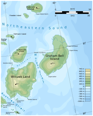
| The east of Franz Josef Land with Wilczekland | ||
| Waters | Arctic Ocean | |
| Archipelago | Franz Josef Land | |
| Geographical location | 80 ° 35 ′ N , 60 ° 30 ′ E | |
|
|
||
| length | 57 km | |
| width | 47 km | |
| surface | 2 203.3 km² | |
| Highest elevation | (Wüllerstorfberge) 606 m |
|
| Residents | uninhabited | |
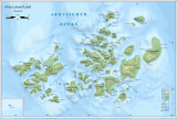
| Location of the Wilczekland | ||
Wilczekland ( Russian Земля Вильчека , Semlja Wiltscheka ) is an island in the southeast of Franz Josef Land in the Arctic Ocean . It is located on Austria Sound across from Hall Island . Wilczekland is the second largest island in the archipelago with an area of around 2200 km². With the exception of a few narrow coastal areas in the north and south of the island, the surface of the up to 606 m high Wilczek Land is almost completely glaciated.
In the Persey Bay on the south coast, about 9 km from Wilczek Land (at 80 ° 21 ' N , 60 ° 15' O ), is based on the 4 sq km Klagenfurt Island (Остров Клагенфурт). It is named after the capital of Carinthia .
history
Wilczekland was discovered in 1873 by the Austro-Hungarian North Polar Expedition (1872–1874) and - like Wilczek Island before it - was named after the company's most important sponsor, Johann Nepomuk Graf Wilczek . Julius Payer mapped the south and west of the island in spring 1874 during a dog sled excursion .
A group led by Evelyn Baldwin set up a depot at Cape Heller during Walter Wellman's failed North Pole expedition of 1898/99. To guard him, Baldwin left two expedition members, the Norwegians Bernt Bentsen (1860–1899) and Paul Bjørvig (1857–1932), in a primitive dwelling made of piled stones in October 1898 . Bentsen fell ill in November and died in early January 1899. Bjørvig kept the frozen body in the sleeping bag in the hut until Wellman's arrival on February 27, so as not to leave it to the polar bears . Bentsen was buried at Cape Heller. In 1960, Soviet researchers restored the grave and placed a memorial plaque. The mapping of the east coast of Wilczekland and the discovery of the neighboring Graham Bell Island by Baldwin represent the real achievement of the Wellman expedition.
Individual evidence
- ↑ a b UNEP Islands (English).
- ↑ Friedhelm Thiedig: Journey to the Geographical North Pole and Franz Josef Land (2005) - with a description of the Klagenfurt Islands and the strikingly large stone spheres east of Cape Fiume on Champ Island (FJL). In: Carinthia II. 196/116. Volume 1, Klagenfurt 2006, pp. 9–32 ( PDF (11.2 MB) on ZOBODAT )
- ^ PJ Capelotti: EB Baldwin and the American-Norwegian discovery and exploration of Graham Bell Island, 1899 . In: Polar Research . Volume 25, No. 2, 2006, pp. 155-171. doi : 10.3402 / polar.v25i2.6245
Web links
- Andreas Umbreit: Wilczek-Land on the Franz-Joseph-Land Info website


