
Kuhn Island (Franz Josef Land)
| Kuhn Island | ||
|---|---|---|
 |
||
| Waters | Arctic Ocean | |
| Archipelago | Franz Josef Land | |
| Geographical location | 81 ° 7 '32 " N , 58 ° 23' 34" E | |
|
||
| length | 7.8 km | |
| width | 5 km | |
| surface | 17.5 km² | |
| Highest elevation | 228 m | |
| Residents | uninhabited | |
 |
||

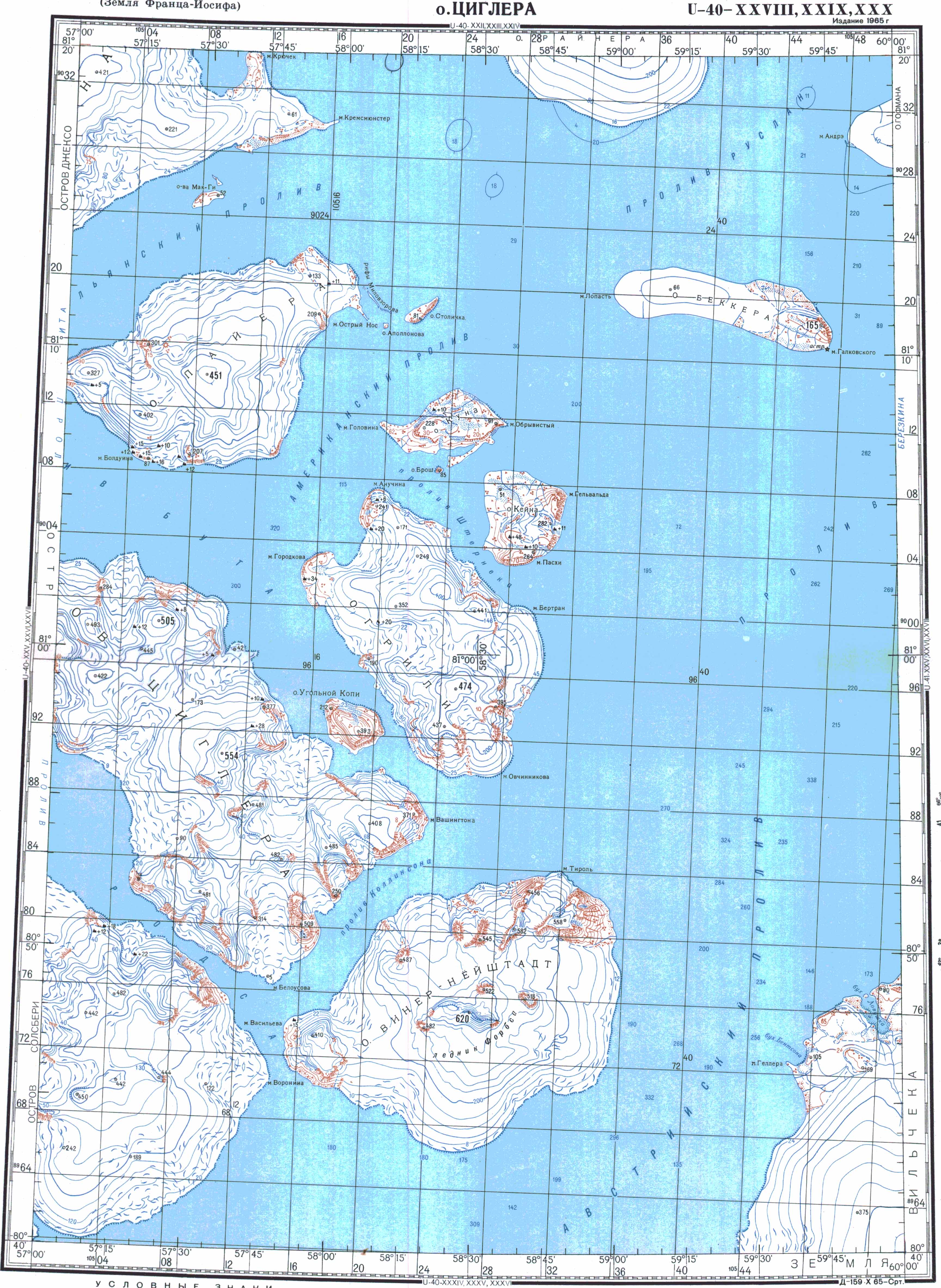
The Kuhn Island ( Russian Остров Куна ; Ostrow Kuna) is an island in the arctic Franz Josef Land . Administratively, it belongs to the Russian Arkhangelsk Oblast .
geography
The largely unglaciated Kuhn Island is between its western (Mys Golowina) and eastern (Mys Obrywisty, steep cape ) almost 8 km long and up to 5 km wide in a north-south direction. Their area is about 17.5 km². In the south, a 2 km long peninsula extends in a south-westerly direction with an island, the Brosch Island , in front of it. The largest elevation on Kuhn Island is 228 m.
The island is located in the east of the central group of Franz Josef Lands (Zichy Islands). In the south-east lies the also largely unglaciated Kane Island at a distance of 1.5 km . Both islands are separated from the larger Greely Island in the south by Sterneck Sound . To the west is the Payer Island , to the north the Stoliczka Island and about 10 km northeast of the Becker Island .
history
The Austro-Hungarian North Pole expedition discovered Franz-Josef-Land in August 1873. The Kuhn Island is already entered under this name on the first map of the archipelago. However, it was not entered by the expedition members, as their path in April 1874 led them along the east bank of Kane Island. Julius Payer got an overview by climbing Cape Hellwald in the northeast of Kane Island on April 17th. The Kuhn Island was named by Payer after the Austrian Minister of War Franz Kuhn von Kuhnenfeld , who sponsored the expedition.
Individual evidence
- ↑ Topographic map U-40-XXVIII, IXXX, XXX (scale 1: 200,000)
- ^ Julius Payer: The Austro-Hungarian North Pole Expedition in the years 1872–1874 , Alfred Hölder, Vienna 1876. Original map of the Emperor Franz Josef Land
- ^ Julius Payer: The Austro-Hungarian North Pole Expedition in the years 1872–1874 , Alfred Hölder, Vienna 1876. P. 345 f.
Web links
- Andreas Umbreit: Kuhn Island on the website www.franz-josef-land.info
Aagaard Island | Adelaide Island | Alexandraland | Alger Island | Apollo Island | Arthur Island | Becker Island | Bell Island | Berghaus Island | Bliss Island | Borisjak Island | Brady Island | Brooch Island | Brice Island | Bromwich Island | Brown Islands | Bruce Island | Champ Island | Coburg Island | David Island | Davis Island | Derevyanny Island | Dicks Island | Eaton Island | Etheridge Islands | Elizabeth Island | Eva Liv Island | Freeden Island | Geddes Island | Gorbunow Island | Graham Bell Island | Greely Island | Hall Island | Harley Island | Hayes Island | Hochstetter Islands | Hoffmann Island | Hohenlohe Island | Hooker Island | Houen Island | Ivanov Island | Jackson Island | Jefferson Island | Kane Island | Karl Alexander Island | Klagenfurt Island | Kling Island | Bud Island | Koettlitz Island | Koldewey Island | Komsomol Islands | Kupolok Island | Kuchin Islands | Kuhn Island | La Ronciere Island | Lamont Island | Leigh Smith Island | Levanewski Island | Luigi Island | Luetke Island | Mabel Island | MacGee Islands | May Island | Maly Island | Marley Island | Mathilda Island | McClintock Island | McNulty Island | Nansen Island | Newcomb Island | Newton Island | Nitsch Island | Northbrook Island | Nowy Island | Ommanney Island | Payer Island | Mother-of-Pearl Island | Pontremoli Islands | Prince Georg Land | Querini island | Rainer Island | Robinson Island | Royal Society Island | Rudolf Island | Salisbury Island | Salm Island | Schönau Island | Scott Keltie Island | Solovyov Island | Stoliczka Island | Sub-island | Tillo Island | Torup Island | Tom Island | Trjochluchewoi Island | Chichagov Islands | Udachny Island | Ugolnoi Kopi Island | Weyprecht Island | Windward Island | Wiener Neustadt Island | Wilczek Island | Wilczek-Land | Ziegler Island