Neva
| Neva | ||
|
River course |
||
| Data | ||
| location | Leningrad Oblast , Saint Petersburg ( Russia ) | |
| River system | Neva | |
| source |
Lake Ladoga 60 ° 48 ′ 58 ″ N , 31 ° 31 ′ 41 ″ E |
|
| Source height | 4 m above sea level Baltic Sea | |
| muzzle | near Saint Petersburg in the Baltic Sea coordinates: 59 ° 56 ′ 43 ″ N , 30 ° 10 ′ 15 ″ E 59 ° 56 ′ 43 ″ N , 30 ° 10 ′ 15 ″ E |
|
| Mouth height | 0 m above sea level Baltic Sea | |
| Height difference | 4 m | |
| Bottom slope | 0.05 ‰ | |
| length | 74 km | |
| Catchment area | 281,000 km² | |
| Drain |
MQ |
2500 m³ / s |
| Left tributaries | Moika | |
| Big cities | St. Petersburg | |
| Medium-sized cities | Kirovsk , Otradnoye | |
| Small towns | Key castle | |
| Navigable | 74 km | |
|
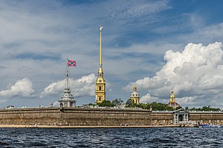
The Neva in Saint Petersburg |
||
The Neva ( Russian: Нева ) is a 74 km long river in Russia that flows from Lake Ladoga into the Neva Bay of the Baltic Sea . It crosses Saint Petersburg .
course
The Neva river system gets its name from the last 74 kilometers of the river, but drains a very large catchment area via the two large tributaries of Lake Ladoga ( Volkhov and Swir ). The average water runoff of the Neva of around 2500 m³ / s is only slightly lower than the average water runoff of the Rhine .
The most important river arms in the Neva Delta are the Great and Small Neva and the Great, Middle and Small Nevka.
| Surname | region | Length, km |
|---|---|---|
| Great Neva (Bolshaya Neva) | from the Fontanka estuary to the Blagoveshchensky bridge | 2.40 |
| From the Blagoveshchensky Bridge to the Castle Bridge | 1.22 | |
| Little Neva (Malaya Neva) | 4.85 | |
| Jekateringofka | 3.60 | |
| Zhdanovka | 2.20 | |
| Smolenka | 3.30 | |
| Great Newka (Bolshaya Newka) | from the Neva to the Little Nevka | 3.70 |
| from the Little Newka to the Middle Newka | 2.05 | |
| From the Middle Newka to the Neva Bay | 2.15 | |
| Middle Nevka (Srednjaja Newka) | 2.60 | |
| Little Newka (Malaja Newka) | 4.90 | |
| Karpovka | 3.00 | |
| Krestovka | 0.74 | |
| Fontanka | 6.70 | |
| Moika | 4.67 | |
| Griboyedov Canal | 5.00 | |
| Prjashka | 1.32 | |
| Kryukov Canal | 1.15 | |
| Obvodny Canal | 8.08 |
There are shipping connections to the White Sea , Volga , Caspian Sea , Azov Sea and Black Sea via various canals and waterways .
bridges
The bridges (road bridges, unless otherwise stated) over the Neva main fairway (Neva and the Great Neva estuary) are, in the direction of flow:
- Ladoga bridge (trunk road R21 below Schluesselburg )
- Kusminka bridge (rail lifting bridge along the route Ladoga Station - Mga in Kusminka above Otradnoje )
- Great Obuchowski Bridge ( ring road )
- Volodarsky Bridge , 1993
- Finnish Railway Bridge (lift bridge on the connecting line between Moscow Railway - Ladoga Railway Station - Finnish Railway Station )
- Alexander Nevsky Bridge (by tram)
- Bolsheochtinsky Bridge
- Liteiny Bridge (by tram)
- Troitski Bridge (by tram)
- Castle Bridge
- Blagoveschensky Bridge (formerly Leutnant Schmidt Bridge)
The first two bridges are located in the area of Leningrad Oblast , the Great Obukhovsky Bridge on the city limits of Saint Petersburg, the rest in the urban area. Before the confluence of the Great Neva, the Neva Bay is crossed by a cable-stayed bridge during the Sapadny skorostnoi diametr expressway, which was completed in 2016 ; likewise the other mouth arms in the mouth area into the bay (from north to south Great Newka, Little Neva, the Sea Canal and Jekaterinowka), while the Smolenka is crossed by a tunnel.
During the night between 2 and 5 a.m. in Saint Petersburg, the Neva road bridges are opened, after which there is no longer any connection between numerous parts of the city. During the White Nights from the end of June to mid-July, the passage of the ship convoys is a spectacle that thousands of people watch despite the sleep time.
See also
- Battle of the Neva 1240
- In 1789 Jakob II Bernoulli drowned in the Neva.
- In 1916 the spiritual healer Grigori Rasputin was thrown into an ice hole in the Neva after previous murder attempts and drowned.

