Swir
|
Swir Свирь, Syväri |
||
|
Course of the White Sea-Baltic Sea Canal with section Swir |
||
| Data | ||
| Water code | RU : 01040100712102000011922 | |
| location | Leningrad Oblast ( Russia ) | |
| River system | Neva | |
| Drain over | Neva → Baltic Sea | |
| origin |
Lake Onega 60 ° 59 ′ 30 ″ N , 35 ° 29 ′ 49 ″ E |
|
| Source height | 33 m | |
| muzzle |
Lake Ladoga Coordinates: 60 ° 30 '43 " N , 32 ° 47' 34" E 60 ° 30 '43 " N , 32 ° 47' 34" E |
|
| Mouth height | 4 m | |
| Height difference | 28.5 m | |
| Bottom slope | 0.13 ‰ | |
| length | 224 km | |
| Catchment area | 84,400 km² | |
| Drain |
MQ |
790 m³ / s |
| Left tributaries | Ojat , Pasha | |
| Right tributaries | Vashinka | |
| Navigable | Throughout the process | |
|
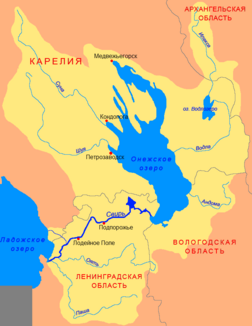
Catchment area of the Swir |
||
The Swir ( Russian Свирь , Finnish and Karelian Syväri ) is a river in Leningrad Oblast in northwestern Russia . It begins at Vosnessenje ( Вознесенье , in the south of Lake Onega) and flows into Lake Ladoga after 224 km. The Swir connects the two largest lakes in Europe, Lake Onega and Lake Ladoga . It is also part of the White Sea-Baltic Sea Canal and the Volga-Baltic Sea Canal . Two river power plants use the height difference of 28.5 m and divide the river into the Upper Swir (93 km), Middle Swir (45 km) and Lower Swir (80 km).
The width is only 100 meters near the town of Podporoshje , which makes it difficult for the many ships to cross. In the flooded Iwinsk Basin ( Ивинский Разлив ) it reaches a width of 10 to 12 kilometers. The Verkhniye Mandrogi museum village is on the river .
The Swir represents the traditional southern border of the Karelia landscape.


