Pasha (swir)
|
Pasha Паша́ |
||
| Data | ||
| Water code | RU : 01040100812102000013277 | |
| location | Leningrad Oblast ( Russia ) | |
| River system | Neva | |
| Drain over | Swir → Neva → Baltic Sea | |
| origin |
Paschosero 60 ° 1 '59 " N , 34 ° 31' 58" O |
|
| Source height | 115 m | |
| muzzle |
Swir coordinates: 60 ° 28 ′ 59 " N , 32 ° 55 ′ 7" E 60 ° 28 ′ 59 " N , 32 ° 55 ′ 7" E |
|
| Mouth height | 4.5 m | |
| Height difference | 110.5 m | |
| Bottom slope | 0.46 ‰ | |
| length | 242 km | |
| Catchment area | 6650 km² | |
| Drain |
MQ |
70 m³ / s |
| Right tributaries | Kapscha | |
| Communities | Pasha | |
|
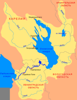
Location of the Pasha (Паша́) in the catchment area of the Swir |
||
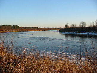
The Pascha ( Russian Паша́ ) is a left tributary of the Swir in Leningrad Oblast in the north of the European part of Russia .
The Pascha has its origin in the lake Paschosero on the Vepsovsk heights . It flows through a swampy and forested landscape in a predominantly north-westerly direction and reaches the Swir - 7.9 km before its confluence with Lake Ladoga . The pasha has a length of 242 km. It drains a catchment area in the east of Leningrad Oblast, which covers an area of 6650 km². The mean discharge is 70 m³ / s. The maximum outflow is 1200 m² / s.
The snowmelt makes a significant contribution to the annual runoff. The river is frozen between November and the second half of April.

