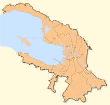
Newabove

Coordinates: 59 ° 56 '23 " N , 29 ° 59' 29" E
The Neva Bay ( Russian Невская губа ; also Kronstadters bay, Russian залив Кронштадтский , Kronschtadtski saliw, there However outdated for the entire Gulf of Finland ) is the easterly tributaries of the Baltic Sea , an elongated shallow bay of the Gulf of Finland in the region of the mouth of the Neva in those.
description
The bay lies entirely within the urban area of Saint Petersburg , is about 22 kilometers long and up to 15 km wide, the water depth is only three to five meters. It extends from the Neva delta in the field of Vasilyevsky Island and several smaller islands in the center of St. Petersburg to the island of Kotlin (with the Municipality Kronstadt ), where it since the 1980s by the Saint Petersburg Dam wider from far and deeper part of the Meerbusens is almost separated. Along the northern coast of the bay are the smaller towns of Lachta , Lissi Nos and Olgino , which belong to Saint Petersburg , and several cities and settlements that are also subordinate to Petersburg, including Strelna , Peterhof and Lomonossow , on its southern coast . If one takes the dam as the exact western boundary of the Newabove, the area for the latter is 380 km².
Before the dam was built, the waters of the Neva Bay caused frequent floods in Saint Petersburg, especially westerly winds that drove the water eastward, preventing the Neva from flowing out, causing the river's level to rise rapidly. With the embankment of the dam, the risk of flooding was largely averted, but the water east of it has since been considered particularly heavily polluted, as the bay absorbs the water from the Neva, which is polluted by runoff, and the exchange of water with the rest of the Baltic Sea due to the existence of the dam is made very difficult.
In the summer months, the average water temperature in the Newa Bay is 17 to 19 ° C. The bay freezes over from November to April, but shipping traffic is maintained all year round thanks to the use of icebreakers .
Others
In allusion to its shallow water depth, the bay has been nicknamed the "Marquis Puddle" (Russian Маркизова лужа ) since the early 19th century . It owes this name to Jean-Baptiste Prevost de Sansac, marquis de Traversay , a statesman of French descent in Saint Petersburg who was naval minister of the Russian Empire from 1811 to 1828 and who tried during his tenure to use the Neva Bay as the only training ground for ships of the Russian fleet .
There are currently plans to fill in larger artificial land along the eastern coastal areas of the Newa Bay and to build various residential and business districts as well as infrastructure objects on them. A first project within the scope of this plan, the new passenger terminal for cruise and ferry ships, was implemented in 2008. A total of around 100 million cubic meters of ground is to be poured, which will shift the coastline of the Petersburg city center by one kilometer to the west.
Individual evidence
- ↑ "Marquis Puddle" (Маркизова лужа) in the online encyclopedia Saint Petersburg (English, Russian )
- ↑ http://www.regnum.ru/news/1026907.html
- ↑ http://www.gov.spb.ru/gov/admin/otrasl/invest/gov/admin/otrasl/invest/int/22062005 ( Memento from May 4, 2011 in the Internet Archive )
Web links
- Newabucht in the online encyclopedia Saint Petersburg (English, Russian )
- Data on the Bay of Neva and the eastern part of the Gulf of Finland (Russian)

