Vasilyevsky Island
| Vasilyevsky Island | ||
|---|---|---|
| The eastern tip (Strelka) of Vasilyevsky Island with the Rostra columns, the Castle Bridge on the left, the Stock Exchange Bridge on the right | ||
| Waters | Newa Bay , Baltic Sea | |
| Geographical location | 59 ° 56 '24 " N , 30 ° 15' 36" E | |
|
|
||
| length | 6.6 km | |
| width | 4.2 km | |
| surface | 10.9 km² | |
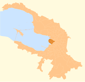
| Location of the island in the urban area (dark picture) | ||
The Vasilyevsky Island ( Russian Васильевский остров ) is an island in the Neva Delta between the rivers Great Neva and Little Neva and the Neva Bay of the Baltic Sea in Saint Petersburg . From around 1730 to 1880, this junction of the Neva was home to the Petersburg port with quays, customs, department stores and the market for imported goods.
geography
The extension from north to south is 4.2 km, from west to east 6.6 km. The area of the island is 1090 ha. Four bridges connect the island with other parts of the city, these are the Tutschkow Bridge , the Börsen Bridge , the Castle Bridge and the Blagoweschtschenski Bridge (formerly Lieutenant Schmidt Bridge).
Development
The older buildings that have been preserved extend along the university quay on the banks of the Neva:
- Alexander Danilowitsch Menshikov , a favorite of Peter the Great , had received large parts of the island as a gift from him and from 1713 had an extensive palace built, the first stone building in the royal seat. The current exterior, however, reflects the condition from 1734.
- The Kunstkammer (1718–1734) was also started while Peter I was still alive.
- The twelve colleges , a block of ministerial buildings from the years 1722 to 1742 placed perpendicular to the Neva, serve the university today .
- The art academy followed from 1764 to 1788, and
- the Academy of Sciences got a large building on the Neva from 1783 to 1789.
Immediately after the turn of the 19th century, the development on the Strelka (Russian: "arrow"), the eastern tip of the island, was redesigned. Thomas de Thomon , a Swiss man who came to Petersburg from Paris around 1800, worked with Andrejan Dmitrijewitsch Sakharov until 1804 to develop the urban planning solution for this central architectural ensemble of bank stairs, Rostra columns and stock exchange, which was completed by 1810. First, a symmetrical bank line and a semicircular square were created by backfilling.
- The stock exchange stands in its central axis . The building erected by Thomon between 1804 and 1810 in the form of an ancient peripteros follows the model of the Poseidon temple in Paestum . The side figures of Neptune and Mercury , gods of the sea and of trade, indicate that this was once the center of long-distance trade. Between 1940 and 2010 the building served as a naval war museum .
- It is flanked by the two red, 32 m high Rostra columns , designed by Thomas de Thomon in 1810. Bronze ship's beaks (Latin: Rostra ) protrude from them, like symbols of conquered fleets in ancient Rome. There are beacons at the top, but their gas torches are only lit on public holidays. The four colossal stone figures on the bases represent the Russian rivers Volga , Dnieper , Neva and Volkhov , they come from the Flemish sculptor Joseph Camberlin (1766-1821) and the French J. Thibaud.
Later followed
- the Zoological Museum in the former Zoological Institute (1826–1832),
- more than four Russian Orthodox churches
- and two Protestant churches.
literature
- Natalja Popowa: Saint Petersburg and its suburbs ; Pages 24–26, Art Publishing House “P2”, St. Petersburg 2007, ISBN 5-93893-299-8
Web links
Footnotes
- ↑ Monuments in St. Petersburg
- ↑ G. Komelova: The architecture of St. Petersburg in 1800 . In: St. Petersburg around 1800. A golden age of the Russian tsarist empire , Recklinghausen 1990, p. 52.
- ^ Zoological Museum


