
Quito
| Quito | ||
|---|---|---|
|
Coordinates: 0 ° 13 ′ S , 78 ° 31 ′ W Quito on the map of Ecuador
|
||
| Basic data | ||
| Country | Ecuador | |
| province | Pichincha | |
| City foundation | December 6, 1534 | |
| Residents | 2,735,987 (2019) | |
| City insignia | ||
|
|
 |
|
| Detailed data | ||
| surface | 290 km 2 | |
| Population density | 4,827 inhabitants / km 2 | |
| height | 2850 m | |
| City structure | 8 zonas | |
| Post Code | EC1701 (170101 - 170186) |
|
| prefix | (+593) 2 | |
| Time zone | UTC -5 | |
| City Presidency | Jorge Yunda | |
| Website | ||
 |
||


Quito ( San Francisco de Quito ) [ ˈkito ] is the capital of Ecuador . It is located 20 kilometers south of the equator in a 2850 m high basin of the Andes and is therefore the highest capital in the world even before the Bolivian capital Sucre . With around 2.7 million inhabitants, it is one of the two largest cities in the country alongside Guayaquil . It is also the capital of the canton of the same name and the province of Pichincha . The old town of Quito is a UNESCO World Heritage Site .
geography


Quito is located in the northern center of Ecuador in the Andes region ( Sierra ), in the east of the Pichincha province . The city center is about 22 kilometers south of the equator , the northern outskirts about 13 kilometers. The city is located approximately between 0 ° 4 'and 0 ° 20' south latitude and between 78 ° 25 'and 78 ° 33' west longitude.
The city runs in a north-south axis in a narrow longitudinal valley typical of the Andes, which belongs to the Guayllabamba Basin (also called Quito Basin), one of the eight inner Andean basins in Ecuador. The Guayllabamba Basin extends about 50 kilometers in a north-south direction and is about 4 kilometers wide in a north-east direction. The southern end of the basin is on Atacazo Mountain (south of Quito), the northern end on Pululahua (near San Antonio de Pichincha ). The city lies directly at the foot of the inactive and non-glaciated volcano Rucu Pichincha (4,690 m), which rises on the west side of Quito and forms the boundary of the basin. The Guagua Pichincha volcano directly behind is slightly active and a little higher (4,794 m), but cannot be seen directly from Quito. On the west side, a series of smaller volcanoes and mountains form the boundary along which the Guayllabamba River runs. The Panecillo hilltop , south of the old town of Quito, is considered to be the middle sheath that separates a southern plain from the northern valley. The southern plain includes the Valle de los Chillos (with Chillogallo ), the northern, modern districts of Quito and the higher areas around Iñaquito and Cotocollao are located in the northern valley .
From Quito you have a spectacular view to the southeast of the Cotopaxi volcano (5897 m). In the wider area there are also the active volcanoes Cayambe (5790 m) and Antisana (5753 m) as well as the extinct Illinois (5263 m) and numerous smaller ones. Besides the Guayllabamba, the Machángara is the most important river. It flows to the east through an interruption of the eastern boundary of the valley, formed by its valley and consisting of steep slopes, behind which Guápulo and the valley of Tumbaco lie. Other rivers are the Monjas, the Pita and the Río San Pedro, all of which are part of the Guayllabamba river system.
geology
Almost all of Quito is located on sandy soils of volcanic origin. Earthquakes and ash falls have plagued Quito in the past and present. Quito is surrounded by 14 volcanoes, and destroyed buildings in the old town have been rebuilt at least four times after earthquakes.
The last major volcanic eruption occurred in September 2002. At that time, the Reventador volcano, east of the Andes, erupted , which had been quiet for over 20 years. A state of emergency had to be declared in Quito, as the entire city and the entire valley east of Quito was covered ankle-deep with fine ash.
The special location in the valley at the foot of the Pichincha means that the urban area, especially in the area of the center, has steep gradients in east-west direction of often more than 10% and the associated steep streets .
Much of the soils in the urban area are basically fertile and used to be cultivated, which has shaped the town's rural character for centuries. Today this is no longer possible due to the dense population; In the suburbs, agriculture is not productive due to the high altitudes on volcanic flanks, with the exception of the valleys particularly west and south of Quito (including Tumbaco , Pifo , Píntag ). Erosion is a major problem especially north of the city and in the river valleys. To the west of Quito, parts of the volcanic layer have already been completely eroded away, and a Duripan layer ( hardened by silica ) has emerged.
Expansion of the urban area
The city of Quito has an area of around 290 km² and 1,499,614 inhabitants (2004). The catchment area of the city is around 1,000 km² and has around 2 million inhabitants.
Due to the narrow valley, the urban area is only wider than two to three kilometers in a few areas and extends lengthways in a north-south direction for more than 30 kilometers. It can essentially be divided into three parts: a center around the colonial old town and the modern districts to the north in the center, north and south.
The colonial old town extends essentially from the Panecillo in the south to the Alameda Park in the north, which is followed by a mixed district that extends to El Ejido Park and to the north, in turn, the modern city and financial center between Ejido and Carolina -Park adjoins (“Mariscal Sucre” district and the north of Avenida Colón ). It has an extension of about 8 kilometers in north-south direction and 500–2000 m in east-west direction. In the colonial center are the presidential palace, the cathedral and the basilica as well as the churches, convents and secular buildings that make the city a world cultural heritage . The northern part of the center houses the financial center, which only grew in the 1970s and 1980s, government buildings relocated from the old town and the most important shopping centers as well as middle and upper class residential areas.
In the subsequent north of the city are the old airport, residential areas of the middle and upper classes, as well as industrial areas and poorer residential areas on the outskirts. The south of the city is more industrial and largely characterized by middle and lower class districts. The new airport is outside the city proper and can be reached via Cumbaya.
Neighboring municipalities and the canton of Quito
The city of Quito is located in the southern center of the canton of Quito in the east of the Pichincha province , which became the Distrito Metropolitano de Quito (German: Metropolitan District Quito) by a law of December 27, 1993 . The urban area borders on the canton of Mejía ( Machachi ) to the south, the rural communities of Lloa and Nono to the west, the communities of Pomasqui and Calderón to the north and Calderón, Llano Chico, Zámbiza, Nayón, Cumbayá , Guangopolo, Conocoto and to the east Amaguaña. All the municipalities mentioned belong to the canton of Quito.
The Distrito Metropolitano de Quito has an area of around 4,200 km² and 2,036,260 inhabitants (2007 estimate). In addition to the city of Quito, it includes the rural communities of Alangasí, Amaguaña, Atahualpa, Calacalí, Calderón, Conocoto, Cumbayá, Chavezpamba, Checa, El Quinche, Gualea, Guangopolo, Guayllabamba , La Merced, Llano Chico, Lloa, Nanegal, Nanegalito, Nayón Nono, Pacto, Perucho, Pifo, Píntag, Pomasqui, Puéllaro, Puembo, San Antonio de Pichincha , San José de Minas, Tababela, Tumbaco , Yaruquí and Zámbiza . The canton of Rumiñahui with its capital Sangolquí is completely enclosed by the canton of Quito, which is also connected to the canton of Mejía in the southwest, the province of Santo Domingo de los Tsáchilas ( Santo Domingo de los Colorados ) in the west, the cantons of San Miguel de los Bancos and Pedro Vicente It borders Maldonado in the northwest, the province of Imbabura ( Cotacachi and Otavalo ) in the north, the cantons Pedro Moncayo and Cayambe in the northeast and the province of Napo ( El Chaco , Quijos and Achidona ) in the east.

City structure


The urban area itself is divided into 19 urban parishes ( parroquias urbanas ). These are:
- Alfaro (named after Eloy Alfaro )
- Benalcázar (named after Sebastián de Benalcázar )
- Chaupicruz
- Chillogallo
- Cotocollao
- La Floresta
- González Suárez (named after Federico González Suárez )
- Guápulo
- La Libertad
- La Magdalena
- El Salvador
- San Blas
- San Marcos
- San Roque
- San Sebastian
- Santa Bárbara
- Santa Prisca
- La Vicentina
- Villa Flora
Eight zonal administrations have been set up to assist in the administration of the Distrito Metropolitano de Quito and to decentralize administrative activities:
- Zona Equinoccial (La Delicia), comprises rural communities in the west and north of the canton
- Zona Calderón, comprises rural communities around Calderón in northeast Quito
- Zona Norte (Eugenio Espejo), covers the north of the city of Quito
- Zona Centro (Manuela Sáenz), comprises the center of the city around the colonial old town and the volcano Itchimbía
- Zona Sur (Eloy Alfaro), covers part of the south of the city
- Zona de Tumbaco, includes rural communities east of the city (including Cumbayá and Tumbaco)
- Zona Valle de los Chillos , includes rural communities southwest of the city (including Píntag)
- Zona Quitumbe , also includes parts of the south of the city, including Chillogallo and Quitumbe
climate
Despite its location on the equator, the climate in Quito is moderate due to the altitude , which is why it is also known as "cold tropical" ( Cfb ). It's also damp. The mean annual temperature is 13 ° C, with temperatures fluctuating significantly more within a day than over the year. Temperatures range between around 6–7 ° C at night and up to 24–25 ° C on warm days. The daytime temperatures are usually between 18 and 21 ° C, which is why Quito is also known as the “city of eternal spring”.
The annual amount of precipitation is around 1,250 mm. There are rainy seasons from September to November and from January to April, the first of which is usually more pronounced. Although these rainy seasons are called "winter", the temperature differences are only small compared to the other months. However, the days have fewer hours of sunshine due to the rainfall. It usually rains around noon and then the sun shines again in the (late) afternoon.
Due to its location on the equator, the days are about the same all year round. The sun rises roughly between 6:15 a.m. and 6:30 a.m. and sets around 6:30 p.m. to 6:45 p.m. The twilight is very short.
|
Average monthly temperatures and rainfall for Quito
Source: WMO , www.climate-zone.com
|
|||||||||||||||||||||||||||||||||||||||||||||||||||||||||||||||||||||||||||||||||||||||||||||||||||||||||||||||||||||||||||||||||||||||||||||||||||||||||||||||||||||||||||||||||||||||||||||||||||
history
Pre-Columbian period

According to legend, Quito was founded by a chief named Quitumbe. According to one version of the founding myth, Quitumbe and his partner Llira were the only ones who survived a deluge by escaping on the Rucu Pichincha. After the water receded , they became the progenitor and mother of the Quitu . According to another version, Quitumbe was the son of the chief of a tribe who came across the sea to the Bay of Caráquez (in today's Manabí ). After that he first founded the city of Tumbes and fathered a son with Llira, a Huancavilca princess from the island of Puná , before following a feather into the Andean highlands and founded a settlement and an empire where the feather sank to the ground.
According to archaeological finds, the Quito plateau was around 1500 BC. The most important finds go back to the so-called Cotocollao culture , a sedentary agricultural culture that can be detected on the plateau until around 500 AD. Historical dates from this period are not known. In the 14th and 15th centuries there were several settlements with local chiefs in the Guayllabamba Basin. Between them there was a large, permanent market (later called Tianguez by the Spaniards ) in the area of today's Plaza San Francisco in the old town of Quito . It cannot be proven that the settlements were subject to a single political rule; but they seem to have been linked in part by marriage. The inhabitants of the northern part of the basin, referred to by Spanish chroniclers such as Pedro de Cieza de León as Zambizas or Quitos , Pillajos and Collaguazos , were evidently culturally part of the Cara who lived further north , while the Panzaleos living in the south differed significantly from them . In addition to its economic importance, the trading center was also of strategic importance, as it was the meeting point of the Andean peoples with the Quijos of the Amazon lowlands and the Yumbo living west of the Andes .
From this strategic importance, after the conquest by the Inca and later by the Spaniards, the idea of a large empire in the north that was antagonistic to the Inca empire developed. Above all, the Jesuit and historian Juan de Velasco (1727–1792) reports on an alliance called Shyrireich of the Quitos , the Cara and other tribes, whose ruling house united in the 14th century with that of the Puruhá from today's province of Chimborazo and that in the In the 15th century, the rulers of the Kañari joined in defense , so that an "empire" emerged that extended to the north of today's Peru ( Paita , Piura ). The depiction of Velasco has already been heavily criticized by Federico González Suárez (1844–1917) and Jacinto Jijon y Caamaño (1890–1950); modern history finds no evidence for the existence of such a large empire.
The Inca probably began to conquer the plain around Quito in the middle of the 15th century, although the efforts of Túpac Yupanquis probably failed due to the resistance, especially from the settlements in the northern area, and a final conquest was only achieved under Huayna Cápac around 1480. According to the tradition shaped by Velasco, Paccha, the daughter of the last Quito ruler Cacha Duchicela, became one of Huayna Cápac's wives and mother of his son Atahualpa, who was possibly born in Quito . Under Huayna Cápac, the trading center remained, and what is now Quito's old town was expanded into a religious and political center. It became the seat of power and court for the area between Riobamba in the south and Otavalo in the north and thus one of the most important cities of the Inca Empire alongside Cuzco and Cajamarca . The rulership structure over the surrounding area was centralized to the place, mitmaqkuna were settled for military control (including Chacha , Kañari and Huancas ).
Colonial times


In the course of the conquest in 1534, the Andean highlands of today's Ecuador were conquered by the Spanish. On December 6, 1534 , the conquistador Sebastián de Belalcázar founded the city of San Francisco de Quito with 202 other Spaniards in the remains of old Quito . In 1541 Gonzalo Pizarro and Francisco de Orellana undertook the Zimtland expedition into the Amazon basin east of the Andes, during which Orellana discovered the Amazon over the Río Napo , while Pizarro returned to Quito.


Quito always remained a regional center in the 16th century. In 1563 Philip II established the Real Audiencia de Quito as the highest court for an area that stretched from the south of today's Colombia to the north of today's Peru and in the east to the mouth of the Napo in the Amazon. The chairman of the court was the governor of Quito, who in turn was subordinate to the viceroy of Peru and later of New Granada.
The indigenous population of the settlements in the surrounding area was summarized in encomiendas or repartimientos , their villages remained in them and increased; Even within the city, the original population was always present due to the existing trading center and obligations to construction and services. In addition, indigenous people in the outskirts of the city were constantly living in “reductions”. The Franciscans were initially commissioned with their missionary work; in the course of the 16th and 17th centuries, further orders were added with the Dominicans , the Mercedarians , the Augustinians and the Jesuits , whose members shaped social life and their churches the cityscape (and today the most important part of the world cultural heritage of Quito). During the entire colonial period, however, the urban character contrasted with the agricultural character of many urban areas.
In the first phase of Spanish colonial rule, a dual society emerged from Spanish and Spanish-born conquerors or landowners and monks on the one hand and indigenous peoples on the other, who were, however, often connected with one another. The production of woolen textiles, which has flourished since the beginning of the 17th century, ensured lasting connections between town and country as well as rapid urban growth, as it attracted both Spanish hidalgos and indigenous workers to the city and its surroundings.
At the beginning of the 18th century, Quito's economy entered a slow, worsening crisis that stretched over the entire century, the main cause of which was the increasingly restrictive tax and trade policy of the Spanish state, which was in financial difficulties, towards its colonies. In Quito, this meant that many wool weaving mills producing for export had to be closed. The dynamic of urban growth decreased significantly and came to a standstill. An expression of dissatisfaction with the increasing tax burden was the Estanco rebellion in 1765 against a new state alcohol and tobacco monopoly, an uprising of the Creole and later also the indigenous population in the Quito neighborhoods, which ultimately had no consequences.
Between 1737 and 1743 the Franco-Spanish Geodetic Mission , headed by Charles Marie de La Condamine, visited Quito to determine the exact position of the equator and to gain knowledge about the shape of the earth. Despite this foreign influence, Quito increasingly isolated itself from new ideas and international trade in the 18th century; Conservative aristocrats and the Catholic orders dominated the intellectual life. The most important critic of those conditions was Eugenio Espejo , who adapted the ideas of the Enlightenment to the Latin American context and tried to spread them.
In connection with the French Revolution and the Napoleonic Wars in Spain , there was a revolution in Quito in August 1809 , which removed the Spanish governor and installed a junta under the leadership of Juan Pío Montúfar . The background to the “Revolution” was not the struggle for the ideas of the French Revolution, but rather the fear that the Napoleonic Wars could lead to their implementation in Quito as well. The leaders of the uprising were loyal to the Spanish crown and tried to prevent change rather than promote it. However, the local upper class from mestizos should have more influence over administrators posted from Spain. The struggle for the influence of the mestizo upper class was also an important motivation for the subsequent wars for independence, which Quito finally came up with after winning the Battle of Pichincha on May 24, 1822 .
Capital of Ecuador
In the Republic of Greater Colombia newly founded under Simón Bolívar , Quito was initially the capital of the so-called Departamento del Sur , before it left the federal government in 1830 and was constituted as the Republic of Ecuador with Quito as its capital.
During the 19th century, Quito and the northern Andean region provided support for conservative, church-loyal political forces, while the coastal region around Guayaquil stood for more secular and free-trade-friendly tendencies. The political landscape was shaped by so-called caudillos , military men who acted as politicians or politicians who had military backing. This led to the capital being the scene of numerous coups. The most drastic of these changes in power were the “ March Revolution ” of 1845, the “National Crisis” of 1859/60 and the “ Liberal Revolution ” since 1895. In the “March Revolution”, a triumvirate from Guayaquil around José Joaquín de Olmedo overthrew the rather in the Andean region supported President Juan José Flores from today's Venezuela . In the civil war of 1859/60, the clerical-conservative Gabriel García Moreno, who was born in Guayaquil but grew up in Quito, prevailed in alliance with Flores against the more liberal troops around Francisco Robles , José María Urbina and Guillermo Franco . He then established a clerical-authoritarian regime, regarded by many as a dictatorship, which found its symbolic climax in a ceremony on March 24, 1874 in the Cathedral of Quito, in the García Moreno and the Archbishop of Quito, José Ignacio Checa , the Republic of Ecuador officially dedicated to the Heart of Jesus . The García Moreno regime, which significantly improved the education and infrastructure of Ecuador, ended with the assassination of the president in 1875. In 1877 Archbishop Checa was poisoned by Good Friday wine mixed with strychnine . As a result of the following 20 years of instability, General Eloy Alfaro succeeded in implementing a comprehensive program of secularization and modernization in the "Liberal Revolution" since 1895. In 1912, after a failed coup d'état against his successor Emilio Estrada , Alfaro was dragged out of prison by a crowd, murdered and burned in Ejido Park.
The era of liberalism in Ecuador came to an end in the " July Revolution " of 1925, a coup by middle-class military personnel. Since a standing army and armed forces emancipated from individual leaders had been created during the liberal revolution , coups since the July revolution were no longer carried out by caudillos but by military juntas and usually ended with the transfer of power to a civilian president. As part of the so-called “ Glorious Revolution ” of 1944, large demonstrations first played an important role in the overthrow of the president, when Arroyo resigned after mass protests and José María Velasco Ibarra became his successor. Velasco, a conservative politician with support in the Andean region, but who at the beginning belonged to the liberal party and was a gifted speaker and populist, was overthrown five times as president and four times by the military. The last fall of Velasco Ibarra in February 1972 ushered in the nine-year military dictatorship in Ecuador. In September 1975, rival generals fought for the presidential palace when Raúl González Alvear tried to overthrow the incumbent Rodríguez Lara from an opposite funeral home, but he was able to defend himself with the help of the naval admiral Alfredo Poveda , who was bloodless in 1976 Successor became. The skirmish left 17 soldiers dead and 80 injured and severely damaged the presidential palace.
Since the 1970s, the oil reserves in the Ecuadorian Amazon region have been systematically exploited, which, especially in the times of the oil crisis, led to rapidly increasing state revenues and an economic boost for Quito, which became the center of the oil industry. The state and administrative apparatus grew rapidly, and foreign investments led to additional economic growth. This attracted large groups of immigrants from the surrounding provinces and intensified the rural exodus to major Ecuadorian cities that has been taking place since the 1940s.
Even after the return to democracy in 1978/79, which was followed by an economic crisis caused by the drop in international oil prices, population growth continued. The population of Quito has since strengthened its reputation as a “rebellious city”, as repeated large demonstrations and general strikes led to the overthrow of presidents: in 1997 Abdalá Bucaram was forced to resign, in 2001 Jamil Mahuad was overthrown and in 2005 Lucio Gutiérrez was ousted .
Population development
The population grew rapidly, especially in the first two centuries after the city was founded, after the city had consolidated its central function and the economy flourished. For the first two centuries, the contemporary information summarized in the table below shows only Spanish and Spanish-born residents, not indigenous (the way in which mestizos were taken into account cannot be clarified). Since the middle of the 18th century, the population has been decreasing, which is explained on the one hand by a flight from the city due to the economic crisis caused by the textile export ban and the weaving closures and on the other hand by diseases and epidemics and increased mortality due to the wars of independence at the beginning of the 19th century. The reduced importance of the city compared to rural Ecuador and the predominance of agriculture shaped the development of Quito until the 19th century. Only the era of the Liberal Revolution and especially the construction of the railway to Quito led to significant population growth, primarily as a result of migration to the capital. Population growth has accelerated parallel to the rural exodus since the 1930s and has reached its peak since the 1970s, when Quito once again gained economic protagonism as an oil metropolis.
| Population development | ||||||||||||||||||||||||||||||||||||||
|
|
|
||||||||||||||||||||||||||||||||||||
Urban growth

The city was founded in 1535 in the center of today's old town on an area of around 17.5 hectares. The first governor, Belalcázar, rigorously followed the pattern of rectangular streets given by the Spanish crown when laying out the streets, which is still noticeable today in the sometimes extremely steep streets in the old town of Quito. Today's Plaza de Independencia took on the role of Plaza de Armas . Whole grid squares of the city were given to religious orders for the construction of monasteries and churches. The floor plan, which was created in the first century of the city's history, remained largely unchanged over the next few centuries and was hardly expanded. Until the 19th century, the urban area remained largely limited to the colonial old town or the area between the Ejido Park in the north and today's Avenida 24 de Mayo (then called "Jerusalem Gorge" and now filled) in the south and thus took it an area of about 1.6 km².
A comprehensive modernization process in the form of electrification, water supply and asphalting of the roads did not begin until the 20th century. However, it lagged behind the massive urban growth that had accelerated since the 1930s and reached its climax in the 1970s, when Quito again gained economic protagonism compared to Guayaquil through the development of the oil reserves in the Amazon lowlands and the rapid expansion of the state apparatus financed from it won.
The growth of the urban area can be seen as a consequence of the rural exodus, which began since liberalization and intensified in the 20th century, especially from the surrounding provinces and regional centers. Large parts of today's built-up Quito were not created until the population grew. The entire areas north of Ejido Park and south of the colonial center were not urbanized until the 1930s, mostly well after the middle of the century. Since the 1960s, rural exodus has resulted in the formation of marginal settlements over large areas, especially in the south of the city, but also in peripheral locations in the north. To the north of the old center, on the other hand, new residential and business districts of middle and higher income brackets emerged, while the colonial center was abandoned by the upper class and inhabited by poor immigrants.
The nominal urban area grew through the incorporation of the surrounding rural areas since the beginning of the 20th century to an unprecedented extent from approx. 2 km² (1904) to 12.8 km² (1959) and 61 km² (1975) and 290 km² (2004).
Large parts of this area, especially in the north, were initially unpopulated and also incorporated into the urban area for speculative purposes, so that the population density stagnated, even decreased, despite the increasing number of inhabitants since the 1950s.
Religions

Due to its colonial past and the strong presence of Catholic orders, Quito is a city strongly influenced by the Roman Catholic faith . Quito is the seat of the Archdiocese of Quito and the Catholic Bishops' Conference of Ecuador. It is estimated that 90% of Ecuadorians are at least formally members of the Catholic Church, a number that should also apply to Quito. The Archdiocese of Quito , which includes the east of the Pichincha Province (the political cantons of Quito, Mejía, Rumiñahui, Pedro Moncayo and Cayambe), has more than 150 parishes, most of them in the city and metropolitan district of Quito. One of them is the German parish of San Miguel Arcángel de los Católicos de Habla Alemana . There are also eight active monasteries in Quito, and a ninth is in neighboring Pomasqui.
In addition to the large number of Catholic churches in Quito, there are also followers and places of worship from the other world religions, including Muslims, Jews, Buddhists and other Christian churches, in particular various evangelical free church denominations, the Adventists and the Igreja Universal do Reino de religious community , which is strongly expanding in Latin America Deus .
Roman Catholic beliefs and rituals are sometimes connected with elements of the original Andean cosmovision , since in the course of missionary work the original beliefs were enriched or overbuilt with Christian equivalents.
politics
City government and administration

The government of the Distrito Metropolitano de Quito is formed by the directly elected mayor, currently Mauricio Rodas, and the city council , the Concejo del Distrito Metropolitano de Quito .
Since the last elections in 2007, the 15 members of the city council have been composed as follows: Izquierda Democrática 8, Quito en Acción 2, PRIAN 1, Partido Sociedad Patriótica 1, Partido Social Cristiano 1, Movimiento PAÍS 1, Alliance of ID and Pachakutik 1.
Politically, the capital, like the Andean region of Ecuador, was mostly ruled conservatively in the 20th century. The Conservative Party provided most of the mayors until the 1960s, but has increasingly lost influence since then and is now meaningless. It was replaced by the Social Christian Party under Sixto Durán Ballén , which was also conservative but less tied to the traditional elites . When this increasingly developed into the party of the entrepreneurial class of Guayaquil in the 1980s, the Christian-Democratic Democracia Popular led by Osvaldo Hurtado and the social democratic Izquierda Democrática succeeded them as dominant parties in Quito. Since the collapse of the Democracia Popular in connection with the overthrow of the president and former mayor of Quito, Jamil Mahuad , the Izquierda Democrática has been the dominant party locally. It also includes Mayor Paco Moncayo, who became known in Ecuador as a general in the Cenepa war against Peru (1995).
The mayor is the head of the city administration, which consists of various independent bodies and five administrative departments. Some of the administrative departments have sovereignty over municipal companies and corporations: the Secretariat for Social Welfare is responsible for the municipal fire brigade and the associations for safety and coexistence and for health as well as the foundations that operate the Sucre National Theater and the City Museum and the Patronato social foundation San Jose . The municipal company for technical equipment and administrative efficiency ( Empresa Metropolitana de Rastro EMR-Q ) and the associations for the airport and the duty-free zone, for tourism, for economic development and competitiveness as well as the foundations for the technology park and for the cabin lift report to the Secretariat for Economic Development TelefériQo . The Territorial Development Secretariat runs the municipal companies for drinking water and sewerage ( EMAAP ), for waste disposal ( EMASEO ), for public buildings ( EMOP ), for transport services and administration ( EMSAT ), the urban development company ( EMDUQ , including for parking lot construction) and as a company organized Fund for the Preservation of the Cultural Heritage ( FONSAL ) as well as the associations for environment Vida para Quito and for air improvement ( Corpaire , especially vehicle inspection ).
In addition, there is the Cabildo Quiteño (literally also city council or traditionally cathedral chapter ) as a decentralized organized participation body. Here, under the chairmanship of the mayor, representatives are represented as zones of the Distrito Metropolitano or through these representatives of parish assemblies. The Cabildo has a say, especially in the area of city ordinances and land use.
Former mayor
- Roque Seville ( DP , 1998-2000)
- Jamil Mahuad ( DP , 1992-1998)
- Rodrigo Paz ( DP , 1988-1992)
- Gustavo Herdoíza (1984–1988)
- Álvaro Pérez ( Partido Liberal , 1980–1984)
- Sixto Durán Ballén ( PSC , 1972–1980)
- Jaime del Castillo Álvarez (1968–1972)
- Julio Moreno Espinoza (1960–1968)
- Carlos Andrade Marín (1956-1960)
- Jacinto Jijón y Caamaño (1940–1944)
coat of arms

The coat of arms of the city of Quito was awarded by a certificate issued on March 14, 1541 in Talavera by Emperor Charles V (as Charles I King of Spain).
Quito was given city rights and the coat of arms used to this day was established. The coat of arms therefore represents: “a castle made of silver between two hills or rocks with a ditch of green color at the foot of each, and above the mentioned castle a cross made of gold with its green foot, which in the hands two black eagles with golden cracks, one in the right hand and one in the left, raised to flight, the entire field red and a cord of St. Francis in gold on a blue field as a border. "
According to a study by the historian and city councilor of Quito Pedro Pablo Traversari from 1914, the oldest surviving depiction of the coat of arms is the one at the Augustinian Convent , which dates from 1573.
Town twinning
Quito has twinned cities with the following cities, but not a single one with a German city:
|
|
|
|
Attractions

Quito has a large colonial old town with numerous important buildings and monuments, especially monasteries and churches in the colonial baroque style , such as the Jesuit church La Compañía and the Church of San Francisco of the Franciscan Convent. Old Quito is the first city ever in 1978 in the list of UNESCO - World Heritage been added.
The new town (Mariscal) north of Ejido Park is home to the National Museum of the Ecuadorian Central Bank and numerous restaurants.
Since 2005 a gondola lift, the TelefériQo , has been leading up a flank of the Pichincha up to almost 4,000 m in the west of the city . From there, the visitor has a view of the city and the mountain panorama. There is an amusement park in the valley station complex.
Pictures of Quito
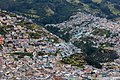
Colorful district above the city

Iglesia la Compañía

El Ejido Park

Park La Carolina
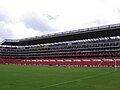
Football stadium

Pichincha volcano (4794 m)

Rucu Pichincha (4690 m)

The Franciscan Monastery with the San Francisco Church

Interior view of the San Francisco Church

Historic center of Quito


education
Quito has two public and several private universities and colleges. The state universities are the Universidad Central del Ecuador (German Central University of Ecuador ) and the Universidad Politécnica Nacional (German National Polytechnic University ). Among the universities of other institutions are the Escuela Superior Politécnica del Ejército (German Politechnical University of the Army ), the Pontifical Catholic University of Ecuador , the Universidad Salesiana (German Salesian University ), the Universidad Andina Simón Bolívar (German Andine University Simón Bolívar ), the Universidad Intercultural de las Nacionalidades y Pueblos Indígenas Amawtay Wasi (German Intercultural University of Indigenous Peoples and Nations House of Wisdom) and the Universidad San Francisco de Quito (German St. Francis University of Quito ) of paramount importance. Since 2002 the private university Universidad Internacional del Ecuador , UIDE (German International University of Ecuador ), has built a new campus, which is the largest in Ecuador.
Numerous private language schools have settled in Quito. In addition to state schools, there are a number of private schools, including a German school, the Colegio Alemán de Quito .
Overall, the level of education in Quito is significantly higher than the national average.
Culture
The culture week in Quito takes place every year in March. The dance festival Women at Dance presents performances in the city's cultural center, the Casa de la Cultura. There are also performances in Guayaquil, Cuenca, Esmeraldas and Cotacachi. Dancers from Argentina, Korea, Croatia, Cuba, Canada and many other countries have been showing their skills since 2002. The Ecuador Jazz Festival also takes place in Quito. Well-known jazz musicians from all over South America are guests at the Sucre National Theater ( Teatro Nacional Sucre ).
In a ranking of cities according to their quality of life, Quito ranked 122nd out of 231 cities worldwide in 2018. In comparison with other Latin American capitals, it was behind Montevideo (place 77), Buenos Aires (place 91), Santiago de Chile (place 92), Brasília (place 108) but still ahead of Lima (place 128), Mexico City (place 129 ) and Caracas (19th place).
traffic
The Quito trolleybus has been operating in the city since 1995 , it runs through the city from north to south and is completely independent of individual traffic. Since the beginning of 2016 is the first 20-kilometer line of the metro Quito metro construction. It is to open in spring 2020 and connect the north (El Labrador) and south (Quitumbe) with the city center.
The international airport Aeropuerto Internacional Mariscal Sucre has been located approx. 15 kilometers (as the crow flies) east of the city since February 2013. It replaced the old airport , located in the middle of the northern city area and no longer up-to-date due to its security risks and insufficient capacity .
The renovated Eloy Alfaro (Chimbacalle) station is the starting point of the Ecuadorian railway , which originally ran to Durán near Guayaquil . Currently there are only tourist trains going to the Cotopaxi Natural Park and Latacunga .
sons and daughters of the town
- Mariana de Jesús de Paredes y Flores (1618–1645), saint; was declared the heroine of the fatherland by parliament in 1945
- Eugenio Espejo (1747–1795), writer, doctor, lawyer and pioneer of independence
- Manuela Sáenz (1797–1856), South American freedom fighter and lover of the liberation hero Simón Bolívar
- Manuel María Pólit (1862–1932), Roman Catholic Archbishop of Quito
- Carlos María de la Torre (1873–1968), Archbishop of Quito and a cardinal of the Roman Catholic Church
- Camilo Egas (1889–1962), painter
- José María Velasco Ibarra (1893–1979), five-time President of Ecuador
- Jorge Carrera Andrade (1903–1978), poet, writer and diplomat
- Jorge Icaza (1906–1978), author and theater director
- Luis Enrique Orellana Ricaurte (1914–1997), Roman Catholic auxiliary bishop in Quito
- Oswaldo Guayasamín (1919–1999), painter and sculptor
- Luis Alberto Luna Tobar (1923–2017), Roman Catholic religious, Archbishop of Cuenca
- Gerardo Guevara (* 1930), composer
- José Ayala Lasso (* 1932), diplomat and politician, first United Nations High Commissioner for Human Rights
- Rodrigo Borja (* 1935), politician, lawyer and university professor, President of the Republic of Ecuador from 1988 to 1992
- Diego Cordovez (1935–2014), diplomat and politician
- Mesías Maiguashca (* 1938), composer
- Maria-Rosa Rodriguez (* 1942), actress and singer
- Freddy Ehlers (* 1945), journalist and politician
- Alberto Acosta Espinosa (* 1948), economist, politician and intellectual
- Jürg Oleas (* 1957), manager with Swiss nationality
- Byron Moreno (* 1969), former FIFA referee
- David Israel de la Torre Altamirano (* 1972) Roman Catholic religious, auxiliary bishop in Quito
- Boris Cepeda (* 1974), pianist and diplomat
- Juan Manuel Correa (* 1999), racing car driver
Others
Quito is namesake u. a. for Quito Glacier , (10793) Quito or Quito (ship) .
Individual evidence
- ↑ Quito se convirtió en la ciudad más poblada del Ecuador con más de 2.7 million de habitantes in the 2018 . Retrieved January 11, 2019.
- ↑ María Augusta Fernández de Castro: "Quito: Crecimiento y Dinámica de una Ciudad Andina", Revista Geográfica del Instituto Panamericano de Geografía e Historia (Ciudad de México), Issue 110, July-December 1989, pp. 121-164, here: 121.
- ↑ The Guayllabamba Basin is located between 0 ° 12 'north and 0 ° 40' south latitude and between 77 ° 55 '45 "and 78 ° 40' 20" west longitude; see Jorge Salvador Lara , Quito , Editorial MAPFRE, Madrid 1992, ISBN 84-7100-437-2 , p. 17; and La Meseta de Quito ( Memento of September 29, 2007 in the Internet Archive ), in the edufuturo.com portal of the prefecture of the Pichincha province , excerpt from Jorge Salvador Lara, Memorias del Ñaupa Quitu , Ediciones Quitumbe, Quito 2002 (Spanish; accessed on 5 March 2007).
- ↑ Sharon Murray, Silvicultura Urbana y Periurbana en Quito, Ecuador: Estudio de Caso , FAO -W7445 / S, Rome 1998, chap. 2.3, online on the FAO website (Spanish).
- ^ Number according to Oswaldo Rivera Villavicencio, Ecuador. Provincias y capitales , Quito: Edigaralde, 2004, p. 240.
- ↑ Fernández de Castro (1989), pp. 129-132.
- ↑ see: Quicentro Sur
- ↑ For more details see under Administraciones Zonales ( Memento of March 6, 2007 in the Internet Archive ), homepage of the city of Quito (Spanish, accessed on March 4, 2007).
- ↑ See Vanessa Zúñiga, Aproximación a un vocabulario visual básico andino , master's thesis at the University of Palermo 2006, ISBN 978-3-659-00600-5 or Jorge Carrera Andrade , El camino del sol.Historia de un reino desaparecido , Quito 1959 (including as a new edition in Quito: Campaña Nacional Eugenio Espejo por el Libro y la Lectura / Casa de la Cultura Ecuatoriana, 2002, 2 volumes, ISBN 9978-92-189-3 and ISBN 9978-92-207-5 ).
- ↑ Cf. Galo Ramón Valarezo, "Quito aborigen: un balance de sus interpretaciones", in: Aguilar u. a. (1992), pp. 29-64, here: 31-44.
- ↑ Juan de Velasco's main work in this context is La historia del Reino de Quito en la América Meridional (published 1778, new edition Fundación Biblioteca Ayacucho, Caracas, 1981); for modern evaluation see Valarezo (1992), 29f., 31-44, 48f.
- ↑ See Valarezo (1992), 44-61.
- ↑ See Rosemarie Terán Najas, “Factores dinámicos en el desarrollo urbano del Quito colonial”, in: Aguilar u. a. (1992), pp. 67-86, v. a. 73–85, and Pablo Ospina, “Quito en la colonía: Abastecimiento urbano y relaciones de poder local”, ibid., Pp. 107–126, v. a. 108-114.
- ↑ Source: Tabla 2.1: Crecimiento poblacional de Quito, 1534–1950 , in: Sharon Murray, Silvicultura Urbana y Periurbana en Quito, Ecuador: Estudio de Caso , FAO-W7445 / S, Rome 1998 (for the years 1534–1922 and 1947 ; Murray gives as sources: Alan Moore, et al., Plan de Manejo, Bosque Protector Pichincha , Quito, AID / PRONAF 1984 (1534–1748) and Ilustre Municipio de Quito, Dirección de Planificación, Quito en Cifras , Quito: IMQ, 1992 (1858-1922, 1947)); Bustos (1992), p. 173 (for 1936, based on Pablo Arturo Suárez, “Estudio numérico y económico social de la población de Quito”, in: Boletín del Departamento Médico Social del Instituto Nacional de Previsión Social , N ° 1, 1937 ), Data from the Instituto Nacional de Estadística y Censos , based on the article "Quito" in the Spanish-language Wikipedia in the version of May 3, 2007 (for 1950-2001).
- ↑ Jorge Salvador Lara (1992), p. 315
- ↑ cf. Fernández de Castro (1989) and Historia in the supplement to the Diario HOY for the Fiestas de Quito 2001 (Spanish).
- ↑ Numbers according to Guillermo Bustos: “Quito en la transición: Actores colectivos e identidades culturales urbana (1920–1950)”, in: Paúl Aguilar u. a., Enfoques y estudios históricos. Quito a través de la Historia , Dirección de Planificación. I. Municipio de Quito / Consejería de Obras Públicas y Transporte de la Junta de Andalucía, Quito 1992, (= Quito series 6), pp. 163-188, here: 173; Jorge Salvador Lara (1992), p. 315; Rivera Villavicencio (2004), p. 210. The city of Quito has various older maps from the 20th century on its homepage ( Memento of April 8, 2008 in the Internet Archive ).
- ↑ Fernández de Castro (1989), pp. 154-158.
- ↑ see the information from the Ecuadorian Catholic Bishops' Conference at www.iglesiaecuador.org.ec ( Memento of September 4, 2008 in the Internet Archive ) (accessed April 15, 2007; Spanish)
- ↑ Nuevos consejeros y concejales se posesionan , Diario HOY , January 5, 2007 (Spanish)
- ↑ An organizational chart can be found here ( Memento from July 11, 2007 in the Internet Archive ) on the homepage of the city administration, information on the municipal companies can be found here ( Memento from February 4, 2008 in the Internet Archive ) and on the corporations here ( Memento from February 4, 2008 in the Internet Archive ). The homepage of the Patronato San José Foundation can be found here ( Memento from February 9, 2008 in the Internet Archive ).
- ^ Proyecto de Participación Ciudadana ( Memento of February 15, 2008 in the Internet Archive ) on the homepage of the city administration or the zonal administration center (Spanish, accessed on February 14, 2008).
- ↑ Álvaro Pérez, Embajador ante Estados Unidos ( Memento from April 10, 2008 on the Internet Archive ), El Mercurio de Manta, May 31, 2005, see also Álvaro Pérez ya no será Embajador ante Estados Unidos ( Memento from May 23, 2016 on the Internet Archives ), El Mercurio de Manta, August 10, 2005 (Pérez has apparently been a member of the Partido Social Cristiano since 1990)
- ↑ Original text: un castillo de plata metido entre dos cerros o peñas, con una cava al pie de cada uno de ellos de color verde, y asimismo encima del dicho castillo una cruz de oro con su pie verde que la tengan en las manos dos águilas negras grietadas de oro, la una a la mano derecha y la otra a la izquierda, puestas en vuelo, todo en campo de colorado, y por orla un cordón de San Francisco de oro en campo azul , according to Escudo de Armas de Quito ( Memento from August 6, 2003 in the Internet Archive ) on the homepage of the city administration (Spanish)
- ↑ The article Quito in the English language Wikipedia also lists a town twinning with Buxton in England, for which no evidence could be found
- ↑ Cuadro de ciudades hermanas de Quito ( Spanish ) Municipio del Distrito Metropolitano de Quito. March 18, 2014. Archived from the original on February 23, 2016. Retrieved on February 23, 2016.
- ↑ Mercer's 2018 Quality of Living Rankings. Retrieved August 18, 2018 .
- ↑ El Metro entrará a operar entre marzo y april del 2020
- ↑ Quiport.com
- ↑ FAZ: Only the danger of fog remained
- ↑ Archived copy ( Memento from September 2, 2011 in the Internet Archive )
literature
- Ernesto Capello: City at the Center of the World: Space, History, and Modernity in Quito. University of Pittsburgh, Pittsburgh 2011, 0-8229-6166-0.
- Paúl Aguilar et al. a .: Enfoques y estudios históricos. Quito a través de la Historia , Dirección de Planificación. I. Municipio de Quito / Consejería de Obras Públicas y Transporte de la Junta de Andalucía, Quito 1992, (= Series Quito 6).
- Jorge Salvador Lara: Quito , Editorial MAPFRE, Madrid 1992, ISBN 84-7100-437-2 .
- María Augusta Fernández de Castro: "Quito: Crecimiento y Dinámica de una Ciudad Andina", Revista Geográfica del Instituto Panamericano de Geografía e Historia (Ciudad de México), issue 110, July – December 1989, pp. 121–164.
Web links
- Official site of the city (Spanish)
- Information about Quito at inquito.com (German)
- Impressions in the picture
- Information about the O-bus system (English)
- Entry on the UNESCO World Heritage Center website ( English and French ).

Heritage: Old Quito (1978) | Historic Center of Santa Ana de los Rios de Cuenca (1999) | Qhapaq Ñan - Andean Road System (2014)
Natural Heritage: Galapagos Islands National Park and Marine Reserve (1978) | Sangay National Park (1983)