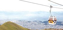
TelefériQo
The TelefériQo (from teleférico and Quito ) is a cable car that went into operation in 2005 in Quito , Ecuador . It leads from the valley station on the outskirts of the city at an altitude of around 3050 m to a mountain called Cruz Loma at around 3950 m on the east side of the Pichincha volcano . When it opened, it was the highest mountain station in the world. (In 2008 it was replaced as such by the Dagu Glacier Gondola in China.)
The cable car is primarily of touristic importance. The valley station is located in an amusement park called Vulqano Park , the mountain station is surrounded by restaurants and souvenir shops . It is also the starting point for - apart from the thin air and rapid weather changes - simple ascent to Rucu Pichincha (4698 m) at a distance (as the crow flies) of about 4.5 km and a mountain bike descent back to Quito. From the mountain station you also have a view of the snow-capped volcanoes Cotopaxi , Cayambe and Antisana as well as numerous other mountains.
Different heights are given for the mountain station between 3996 m according to the manufacturer POMA , 4053 m according to the Quito City Tourism Office and 4100 m on various tourism websites. The lowest answer is more correct.
The length of the runway is generally given as 2500 m, but the manufacturer mentions in the Spanish part of its website 2237 m and a height difference of only 827 m.
The TelefériQo is a gondola lift that is designed as a detachable monocable gondola with 18 gondolas, each with 6 seats. There are 9 more gondolas for different purposes. There are carriers for mountain bikes at the gondolas. The train has a speed of a little over 5 m / s (18 km / h), which leads to a journey time of approx. 18 minutes.
It was built on behalf of a foundation that was financed by donations from local entrepreneurs and the population. The city made the land available and in return receives ownership of the facility after 25 years.
See also
Footnotes
- ↑ ... followed by the Klein Matterhorn (3883 m) and the Aiguille du Midi (3842 m). The highest mountain station had a material ropeway to the Aucanquilcha (5874 m)
- ↑ POMA website ( page no longer available , search in web archives ) Info: The link was automatically marked as defective. Please check the link according to the instructions and then remove this notice. ; in the history section , 2004
- ↑ Quito Tourism Office website (Spanish)
- ↑ Article about the TelefériQo ( Memento of the original from January 15, 2010 in the Internet Archive ) Info: The archive link was inserted automatically and has not yet been checked. Please check the original and archive link according to the instructions and then remove this notice. (Spanish)
Coordinates: 0 ° 11 ′ 32.9 ″ S , 78 ° 31 ′ 6 ″ W.


