Aucanquilcha
| Aucanquilcha | ||
|---|---|---|
|
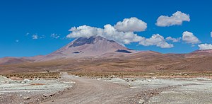
The Aucanquilcha seen from the northwest |
||
| height | 6176 m | |
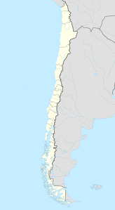
| location | Northern Chile | |
| Mountains | To the | |
| Coordinates | 21 ° 13 ′ 12 ″ S , 68 ° 28 ′ 6 ″ W | |
|
|
||
| Type | Stratovolcano | |
| Last eruption | about 170,000 years ago | |
The Aucanquilcha is a 6176 m high stratovolcano in the Región de Antofagasta in northern Chile on the border with western Bolivia . It is located in the Cordillera Occidental mountain range in the central Andes . To the east of it is the Chilean border station Ollagüe, at an altitude of 3704 m, on the national road Ruta 21 and on the railway to Bolivia. Opposite it rises the 5870 m high volcano Ollagüe . Immediately at the foot of the Aucanquilcha, about 9.5 km from Ollagüe, is the almost completely deserted town of Amincha .
During the Pleistocene , the Aucanquilcha was covered with glacier ice on an area of 45 km², which reached down to 4600 m and left large moraine fields . It is currently still covered in snow and ice down to about 5500 m and still emits fumaroles . Its meltwater is therefore not drinkable.
The mountain was a sanctuary of the Incas . Two ceremonial circles and the remains of fuel-processed yareta plants were found near the summit .
Mining
Near the summit worked since 1913 a sulfur - mine of the Carrasco family belonging SIAM Carrasco SA, the then second largest sulfur mining company in Chile. The mine at Aucanquilcha was the highest mine in the world. The sulfur was mined at altitudes of 5500 m to over 6000 m. The workers were exclusively Quechua Indians from Bolivia, as only they were used to these heights. Their camp, the Campamiento Aucanquilcha, was 5334 m above sea level. It was considered the highest permanently populated place of residence of mankind.
Until 1935, the sulfur obtained in the mine was transported away with the help of llamas , then by a material cable car that transported the sulfur in buckets.
Material ropeway
The remains of this cable car, which went into operation in 1935, are still clearly visible. The first section of the cable car led from the valley station located almost 2 km behind Amincha at 3942 m in a westerly direction to the 12 km away, 5279 m high middle station at Campamento Aucanquilcha . From there a second 1.62 km long section went almost south to the 5874 m high mountain station just below the flat saddle between the summit group and the neighboring western knoll. The cable car thus had a total length of 13.6 km and managed an altitude difference of 1932 m. The mountain station was the highest mountain station in the world. The first section of the cable car consisted of 7 sections of up to 2.8 km in length with 6 intermediate stations. There was a support about every 100 to 150 m. The second section with only a 1.62 km long section had, due to the terrain profile, 4 supports at a maximum distance of 600 m. Further technical details do not seem to be known anymore.
Truck transport
The mine was later developed through roads that could be driven with 20-ton trucks up to a height of 6024 m. A road was also built on the south side of the volcano from a 4778 m high camp near the B-105 to a pit at a height of 5623 m. With the closure of the mine in 1992, these roads lost their importance and are no longer fully accessible due to landslides.
See also
Web links
- Aucanquilcha in the Global Volcanism Program of the Smithsonian Institution (English)
- John Biggar: The Andes: A Guide for Climbers . 3. Edition. Andes Publishing (Scotland), 2005, ISBN 0-9536087-2-7 ( online ).
- Oscar González-Ferrán: Volcanes de Chile . Instituto Geográfico Militar, Santiago, Chile 1995, ISBN 956-202-054-1 (Spanish).
- Shanaka L. De Silva, Peter Francis: Volcanoes of the Central Andes . Springer-Verlag, 1991, ISBN 3-540-53706-6 .
- Loren McIntyre: The High Andes . In: National Geographic . tape 171 , no. 4 . National Geographic Society, April 1987, pp. 422–460 (with photos of mine and summit road).
Spanish language websites
- Volcán Aucanquilcha, Cara Norte / North Face. (PDF file; 1.32 MB) Archived from the original ; accessed on January 11, 2020 (description of the ascent with photos).
- General description
- GRUPO DE TRABAJO DEL PUEBLO QUECHUA (PDF file; 328 kB)
- Estudio Economico sobre la Industria del Azufre en Chile ( Memento of June 17, 2007 in the Internet Archive )
Location information, coordinates
The following location information and coordinates were taken from Google Earth. The distances are always direct, horizontal distances.
- ↑ The camp was at an altitude of 17500 ft at the bend above the middle station of the mountain railway.
- ↑ Valley station: 12933 ft, 21 ° 12 ′ 28.3 ″ S , 68 ° 21 ′ 13.5 ″ W
- ↑ Middle station: 17320 ft, 21 ° 12 ′ 3.6 ″ S , 68 ° 28 ′ 6.9 ″ W
- ↑ Mountain station: 19271 ft, 21 ° 12 ′ 55.3 ″ S , 68 ° 28 ′ 19.1 ″ W
- ↑ ZS1: 21 ° 12'24.61 "S, 68 ° 22'12.52" W; ZS2: 21 ° 12'21.61 "S, 68 ° 23'4.83" W; ZS3: 21 ° 12'18.35 "S, 68 ° 23'58.32" W; ZS 4: 21 ° 12'12.50 "S, 68 ° 25'35.66" W; ZS5: 21 ° 12'8.51 "S, 68 ° 26'42.49" W; ZS6: 21 ° 12'6.65 "S, 68 ° 27'14.51" W.
- ↑ ST1: 21 ° 12'22.59 "S, 68 ° 28'11.60" W; ST2: 21 ° 12'28.10 "S, 68 ° 28'12.86" W; ST3: 21 ° 12'32.01 "S, 68 ° 28'13.78" W; ST4: 21 ° 12'48.58 "S, 68 ° 28'17.67" W.
- ↑ Camp on the B-105: 15677 ft, 21 ° 14 ′ 30.4 ″ S , 68 ° 31 ′ 5 ″ W.


