Antofagasta region
| Antofagasta Region II
Región de Antofagasta |
|||
|---|---|---|---|
| Symbols | |||
|
|||
| Basic data | |||
| Country | Chile | ||
| Capital | Antofagasta | ||
| surface | 126,049.1 km² | ||
| Residents | 607,534 (2017 census) | ||
| density | 4.8 inhabitants per km² | ||
| ISO 3166-2 | CLAN | ||
| Website | www.goreantofagasta.cl | ||
| politics | |||
| Intendant | Fabiola Rivero Rojas | ||
Coordinates: 23 ° 36 ′ S , 70 ° 12 ′ W


Antofagasta is a region in northern Chile (Region II).
geography
The Río Loa is the longest river in Chile with around 443 km, which also flows through the city of Calama .
In the east of the region , the Cordillera Domeyko mountain range stretches for hundreds of kilometers , which is named after the Polish geologist Ignacy Domeyko , who worked in Chile for a long time.
history
Settlement in the Atacama Desert goes back a long way, as early as 5500 BC. The Chinchorro settled the coastal areas. At San Pedro de Atacama there are prehistoric settlement finds of the Atacameños , which are about 3000 years old, z. B. the place Tulor . The first urban-like settlements in the Atacama emerged from around 100 BC. Chr., E.g. B. the Pukará Fort (Pukará de Quitor). It was built by the Atacameños to protect themselves against the other South American peoples. It was later adopted by the Incas .
At the Loa River , the ruins of the pre-Columbian fortress are Pukará de Lasana .
Francisco Pizarro sent Pedro de Valdivia to conquer northern Chile in 1540 . Valdivia encountered hostile Indian tribes such as the Mapuche , Michimalonco, Tangalonco and Atepudo. Some of them fought each other. In the same year he also reached the area around Calama .
Before the saltpetre boom, the port of Antofagasta hardly played a role, Bolivia showed little interest in the city, in which mostly only Chileans lived. In 1866 large saltpeter deposits were discovered around 40 kilometers east of the city of Antofagasta . In 1873 a railway line to Salinas was set up for saltpetre transport. The export of guano fertilizer also played a major economic role during this period. In 1877 the coast around Antofagasta was hit by a severe tsunami .
The affiliation of the Antofagasta region was unclear for a long time. From 1866 to 1879 it was officially part of Bolivia after Chile and Bolivia had contractually agreed that Chilean companies would not have to pay taxes there for 25 years. The Bolivian President declared this agreement null and void at the beginning of 1878 and then made the taxes due retrospectively up to 1874. When the Chilean companies refused to pay, they were confiscated and put up for auction in January 1879. On the day of the planned auction, Chilean troops landed in the port and , from his point of view, the region was recaptured from Chile during the Saltpeter War. Mutually recognized borders were later established between the warring parties through peace treaties, and Antofagasta and Tarapacá were finally integrated into Chilean territory. In 1907 about 36,000 people lived in the saltpetre areas of the Tarapacá and Antofagasta regions .
In 1929 the region plunged into a severe economic crisis, as saltpetre sales had practically collapsed.
Administrative division
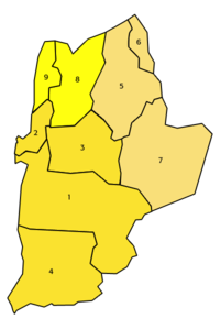
The region consists of 3 provinces.
The biggest cities are:
- Capital Antofagasta 230,000 inhabitants
- Calama 145,000 inhabitants
- Tocopilla 23,000 inhabitants
- Mejillones 9,000 inhabitants
- San Pedro de Atacama 5,000 inhabitants
| province | Capital | Commune |

|
|---|---|---|---|
| Antofagasta | Antofagasta | 1 antofagasta | |
| 2 mejillones | |||
| 3 Sierra Gorda | |||
| 4 valley | |||
| El Loa | Calama | 5 calama | |
| 6 Ollagüe | |||
| 7 San Pedro de Atacama | |||
| Tocopilla | Tocopilla | 8 Maria Elena | |
| 9 tocopilla |
Attractions
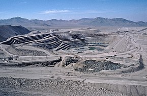
The landscape is dominated by the dry Atacama Desert . The main attractions are the abandoned ghost villages from the saltpetre era and the Chuquicamata open-cast copper mine.
The salt lakes and geysers at El Tatio are also popular. Pink flamingos can be found in large numbers at the salt lakes. The Salar de Atacama is the largest salt lake in Chile with around 3000 km², which is fed by tributaries from the Cordilleras. Due to the desert climate, however, the water evaporates quickly. The geysers are 2000 m higher than San Pedro de Atacama on a plateau in the Andes. They are the highest geysers in the world.
In the valley of the moon, Valle de la Luna , one encounters impressive geological formations, it is located near Calama .
The archaeological museum of the Belgian Padre RP Gustavo Le Paige in San Pedro de Atacama shows numerous finds from the Atacama desert.
economy
Mainly copper ( Chuquicamata and Escondida ) and smaller amounts of sulfur are mined in the region. Fishing plays a certain role on the coast. Tourism is an important source of income in this vast desert landscape.


