
San Pedro de Atacama
| San Pedro de Atacama | ||
|---|---|---|
|
Coordinates: 22 ° 55 ′ S , 68 ° 12 ′ W San Pedro de Atacama on the map of Chile
|
||
| Basic data | ||
| Country | Chile | |
| region | Antofagasta | |
| province | El Loa | |
| Residents | 10,996 (2017) | |
| City insignia | ||
 |
||
| Detailed data | ||
| surface | 23,438 km 2 | |
| Population density | 0.24 inhabitants / km 2 | |
| City structure | Toconao, Socaire, Río Grande, Peine, Camar, Talabre, Matancilla, Machuca, San Pedro de Atacama (urban center) and the Ayllus of San Pedro de Atacama. | |
| Waters | Río San Pedro, Río Vilama, Río Salado, Río Grande, Río Putana, Laguna Chaxa | |
| City Presidency | Sandra Berna Martínez | |
| Website | ||
 |
||

San Pedro de Atacama is a municipality in northern Chile . It is located in the Atacama Desert and includes the oasis villages of San Pedro de Atacama, Toconao, Socaire, Río Grande, Peine, Camar, Talabre, Matancilla, Machuca and some smaller settlements.
geography
The municipality of San Pedro de Atacama is located within the Atacama Desert , one of the driest and most lonely landscapes on earth. Spread over an area of 23,438 km² in numerous small settlements, there are only 10,996 inhabitants. The most populous of these settlements are oases, which are mostly on the edge of an extensive, drainless valley basin at an altitude of about 2400 to 2500 m . The valley is bordered in the west by the Cordillera Domeyko and in the east by the Andean cordillera . At the deepest point, a large salt marsh has formed, the Salar de Atacama . The surrounding rivers collect there, evaporate and deposit their salt load. The Salar de Atacama, which lies in a tectonic rift , is the largest of its kind in Chile with 3500 km² with an extension of 90 km in north-south direction and 35 km in west-east direction. The water catchment area of the Salar is 15,620 km², of which with a total of 50 settlements less than 1.56 km² is used as built-up area and only 2.64 km² is used as arable land.
San Pedro de Atacama oasis
The oasis of San Pedro de Atacama is the administrative center of the municipality. It is located at 22 ° 55 ′ S , 68 ° 12 ′ W at an altitude of 2,450 m on the northern edge of the Salar de Atacama. With 1938 inhabitants in 690 houses, this settlement is the most populous in the municipality. The oasis is a popular destination for 50,000 desert tourists from all over the world every year. The place consists of a group of Ayllus . These are smaller, agriculturally managed oases by indigenous communities, which are sometimes isolated from one another by the desert and are up to several kilometers apart. The Ayllus are spread over an area of 113 km².
The center is formed by the Ayllu Conde Duque. There, the Spanish colonial administration laid out its administrative center in the middle of the older indigenous settlement in the late 16th century. The colonial settlement is characterized by a Plaza de Armas with the church and town hall and the rectangular layout of some streets.
Further central ayllus are Quítor (81 Ew.), Yaye (35 Ew.), Larache (86 Ew.), Solcor (172 Ew.), Séquitor (148 Ew.) And Checar. To the north are Vilama, Cuchabrache, Catarpe, Tambillo, Suchor, Guachar, and Bellavista. To the south are Coyo (34 Ew.), Solor (160 Ew.), Tulor, Beter, Poconche and Cucuter. (Some population figures in brackets) So few people live in the Ayllus Tulor, Beter, Poconche, Cucuter and Cuchabrache that there is still no basic supply of electricity, telephone, water or access to public transport.

Today, tourists stroll through the streets laid out by the Spanish colonial rulers in Ayllu Conde Duque.

North-east corner of the Plaza de Armas. The town hall and rectory are located here.
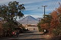
To the east is the Licancabur volcano .

The Ayllu Quitor and Río San Pedro from Pukará de Quitor of view


The entire oasis is irrigated from the rivers Río San Pedro (670 l / s) and Río Vilama (210 l / s), which come from the north. The drinking water is obtained from the Río Vilama and from a well. The main agricultural products are alfalfa , potatoes , corn and pears .
San Pedro de Atacama is located at the traffic junction of a transit route network that connects Argentina and Bolivia in an east-west direction with the coastal region on the Pacific and historically also had importance for the connection in the north-south direction. You can get to Bolivia via the Portezuelo del Cajón pass ( 22 ° 53 ′ S , 67 ° 48 ′ W ) and Argentina via the Jama Pass ( 23 ° 14 ′ S , 67 ° 4 ′ W ), via the Sico Pass ( 23 ° 50 ′ S , 67 ° 15 ′ W ) or over the Socompa Pass ( 24 ° 27 ′ S , 68 ° 17 ′ W ).

Turnpike at the Portezuelo del Cajón pass at 4480 m, border crossing point to Bolivia.

Landscape on the way to the Jama Pass. Salar de Quisquiro 4190 m above sea level M., 25 kilometers from the border with Argentina. The pass is 160 km from San Pedro.

Border crossing to Argentina at the Jama Pass at 4275 m. The nearest Argentine city is 155 km away.

.jpg)

Toconao
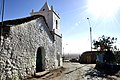
Toconao is located about 36 km southeast of San Pedro de Atacama on the eastern edge of the Salar de Atacama. The oasis is located at 23 ° 11 ′ S , 68 ° 0 ′ W at 2501 m. Around 1884 there were 250 residents here, currently there are 630 living in 331 houses. There are mines nearby that mine lithium , sodium, borax and potassium.

The bell tower of San Lucas in Toconao stands in the Plaza de Armas, isolated from the church across the street.

The street in Toconao between the church and Plaza de Armas
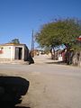
Street in Toconao
The water that makes Toconao an oasis flows through the Quebrada de Jerez.


International radio telescope observatories
North of Toconao at 23 ° 4 ′ S , 67 ° 58 ′ W is the base of operations of the ALMA Radio Telescope Observatory , which is managed by ESO . About halfway (km 17) from San Pedro to Toconao begins the access road to the base, which was laid out at an altitude of 2900 m. There, around 120 people operate and maintain a group of radio telescopes, which are located further east at over 5000 m in the Chajnantor plateau. The local indigenous community in Toconao has property claims over most of the property. The University of Tokyo Atacama Observatory is located on the neighboring Cerro Chajnantor (5640 m) . Furthermore, the Cerro Chajnantor Atacama Telescope is to be set up there. The nearby Cerro Toco there are other radio telescope systems, the Atacama Cosmology Telescope 22 ° 58 ' S , 67 ° 47' W and the James Ax Observatory 22 ° 57 ' S , 67 ° 47' W .

ALMA Operations Support Facility at Toconao. In this service center, observation orders for researchers from all over the world are carried out.
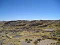
The Chajnantor plateau at over 5000 m is so remote and hostile to life that very few historical anthropogenic traces can be found there.

Some of the radio telescopes in the Chajnantor plateau

Antenna next to the main building


Soncor
Soncor is located 55 km from San Pedro, near Toconao. Around 1884 there were around 30 inhabitants and 10 to 12 hectares of cultivated land. The settlement no longer seems to exist today. Today the Soncor sector is known for a Ramsar wetland with flamingo colonies.
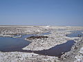
The Laguna Chaxa belongs to the Soncor sector. The salt lake is a habitat for migratory birds and small aquatic animals.

Due to the impassable salt crust of the salar, the lagoon can be reached via footpaths specially created for tourists.

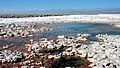
Salt as far as the eye can see. This is what one of the world's most important lithium deposits looks like. The mines are still out of sight.

In the Soncor sector, flamingos nest in the middle of the Salar de Atacama.


Talabre
Talabre is located around 25 km from Toconao. The place with a population of about 50 is 23 ° 19 ' S , 67 ° 53' W . Originally, the settlement was at 23 ° 19 ′ S , 67 ° 50 ′ W at 3600 m, on the slopes of the Talabre Gorge, only about 12 km from the Láscar volcano . After an eruption of the Láscar in 1993, the settlement was abandoned by its then 58 inhabitants and a few kilometers further west in a less endangered place. There is a school on site.

Talabre Viejo: the ruins of the abandoned settlement in the gorge on the road to Lascar
.jpg)
Socaire
Socaire (Spanish for: shelter in the slipstream) is located 89 km southeast of San Pedro. The oasis is located in the Andes cordillera at 23 ° 35 ' S , 67 ° 53' W at 3312 m on the way to the Sico Pass on the border with Argentina. The population increased from 40 to 165 inhabitants between 1884 and 2002. The settlement receives most of the water from the Río Socaire (150-200 l / s) and two streams. The fields of Socaire are terraced systems on mountain slopes, which are mostly further away from the village in the direction of the Sico Pass or in the direction of Toconao. A special feature is that there are two churches in this small settlement.

New Church. The Catholicism had to adapt in the Atacama to the indigenous worldview. That is why the church tower is separate from the church.
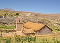
Old Church of San Santiago.
The church and tower face the Miñiques volcano , a mountain sanctuary for the people of Socaire.
Altar of San Santiago
Agriculture is practiced in fields that are laid out in terraces on the mountain slopes.


El Laco
El Laco is located southeast of Socaire in the Andean Cordillera on the way to the Sico Pass on the border with Argentina. It is a mining settlement with 15 inhabitants in 4 houses at 23 ° 51 ′ S , 67 ° 30 ′ W at 4400 m at the foot of the El Laco volcano (5235 m). Iron ores were mined there.

Torment
Peine, also called San Roque de Peine, is located about 100 km from San Pedro on the southeastern edge of the Salar de Atacama. The oasis is located at 23 ° 41 ′ S , 68 ° 4 ′ W at an altitude of 2375 m. Around 1884 the place had 40 to 50 inhabitants and 10 to 12 hectares of pastures and fields could be cultivated. In 1998 there were 286 residents there. There are mines nearby where lithium, sodium, borax and potassium are mined.
San Roque Church in Peine

Tilomonte
Tilomonte (Spanish: Lindenwald) is a green oasis on the southern edge of the Salar de Artacama. The settlement is at 23 ° 47 ′ S , 68 ° 6 ′ W at 2376 m. There is neither electricity nor telephone connections. 2 inhabitants (1992).
More places
- At the Salar de Atacama
- Camar 23 ° 24 ' S , 67 ° 58' W ; 2750 m (indigenous village on the eastern edge of the Salar de Atacama; growing vegetables for personal use; 60 inhabitants 1992)
- Zapar 23 ° 7 ' S , 68 ° 1' W ; 2450 m ( ghost settlement near Toconao; 8 uninhabited houses)
- Tilopozo 23 ° 47 ' S , 68 ° 15' W ; 2300 m (fresh water springs, ponds and marshland at the southern extreme of the Salar near Tilomonte)
- Tulán 23 ° 48 ′ S , 68 ° 2 ′ W ; 2900 m (ruins, east of Tilomonte)
- In the north of San Pedro
- Río Grande 22 ° 39 ′ S , 68 ° 10 ′ W ; 3300 m (village on the river of the same name; 90-100 inhabitants; garlic cultivation ; ceramic factories)
- Machuca 22 ° 36 ' S , 68 ° 4' W ; 3950 m (village, historical retreat for the Atacameños ; 8 inhabitants 1992)
- San Bartolo 22 ° 44 ′ S , 68 ° 13 ′ W ; 2825 m (on the Río Grande; 20 km north of San Pedro; ruins of copper mines that were already exploited by the Incas; 2 inhabitants 1992)
- El Tatio Geysers 22 ° 20 ′ S , 68 ° 1 ′ W ; 4280 m ( geothermal area at the El Tatio volcano )

Rio Grande

Machuca

The Río Grande near San Bartolo

Geyser in El Tatio


.jpg)
Sights in and around San Pedro Atacama
- The archaeological museum founded by the Belgian Padre RP Gustavo Le Paige. The museum shows numerous finds from the Atacama Desert. Among other things, ceramics, textiles and jewelry can be seen. The previously exhibited mummies were removed in 2007 at the request of the indigenous people ( Atacameños ).
- The Church of San Pedro de Atacama is one of the oldest in Chile. Their roof was built with cactus stems .
- The Salar de Atacama , where you can also watch flamingos .
- The geysers of El Tatio . They are 2000 m higher than San Pedro de Atacama on a plateau in the Andes and are the highest geysers in the world. They are particularly active during sunrise because this is the time when the frozen water in the area thaws. A thermal bath can be taken in a special pool.
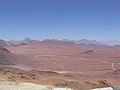
- The dry moon valley Valle de la Luna . It can be planned as a detour on the way to Calama and offers an interesting spectacle, especially during sunset.
- The sources of Puritama ( Termas de Puritama ). 30 ° C hot water rises in a valley in which several bathing pools can be used.
- The Pukará de Quitor (Fortress of Quitor), built by the Atacameños.
- The Valley of Death ( Valle de la Muerte )
- The Miscanti and Miñique lagoons in the Andean plateaus. They are located at over 4000 m in an extraordinary landscape.
- The ruins of Tulor , a former Atacameños village.
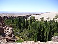
- The Quebrada de Jere near Toconao. A green valley east of the village, traversed by a clear stream.

View over the Valle de la Luna to the Andes

Excavations at San Pedro de Atacama
Laguna Chaxa near San Pedro de Atacama

Salt formations in the Valle de la Luna

View of the Valley of Death (Valle de la Muerte)


.jpg)
Transport links
During the day a bus drives several times to Calama , where the nearest airport and the world's largest open-cast copper mine, Chuquicamata, are located.
The 92 km long road to Calama is well developed and paved. Most of the surrounding indigenous villages, which are not on the main route to Argentina, can only be reached by off-road vehicle.
A bus that travels across the Andes to Argentina stops in San Pedro de Atacama . There is a rail connection from Calama to Bolivia . In addition, a 4-day tour by jeep to Uyuni (Bolivia) is possible from San Pedro de Atacama .
history
Pre-Columbian period
It is estimated that in the Puna region in the north of Chile the first settlements arose around 11,000 years ago. The Atacameños (the indigenous people of the Atacama Desert) were the founders of the so-called "San Pedro Culture" and settled in the oases of the Atacama Desert.
They were the first farmers and thus also the first sedentary group in the country. Since the agriculturally workable zone was very small, they constructed terraces which they irrigated artificially and fertilized with lama dung. Different types of corn, rice, beans, figs, cotton, pumpkins and potatoes were grown.
Llamas and alpacas were kept for meat production and use of the skins. They were also used as a means of transport to trade with the towns on the coast.
The craft and artistic development of the Atacameños can be seen in the manufacture of pottery, fabrics, wickerwork and wood carvings. They also mastered metallurgy and the production of copper and bronze early on.
The Atacameños believed in life after death , which is why the dead were buried with clothing and food for their way to the next life. They worshiped various natural forces, but did not use temples or prayer rooms.
The region has belonged to the Inca Empire since the 15th century
Spanish conquista
The Inca Empire was smashed from 1533 onwards by the Spanish conquerors advancing from Central America. The first invasion of Chile by the conquistador Diego de Almagro soon followed . On the march from Peru to central Chile in early 1536, the captain Ruy Díaz and 115 men came for the first time over the Inca Trail from Chiu-Chiu via San Pedro de Atacama to Toconao. For the troops, the Toconao oasis was the last chance they had to take care of themselves before they could cover the 600 km through uninhabited areas of the Atacama Desert to Chañaral . The actual invasion army with around 500 soldiers and Diego de Almagro had previously advanced further east of it through the Andean plateaus to central Chile, but then took the route via San Pedro de Atacama to retreat to Peru. For security, 80 soldiers were sent ahead by ship to the north, who were then supposed to march via Chiu-Chiu to San Pedro de Atacama to keep the indigenous population in check and to stock up on supplies. In mid-October 1536 the first parts of the main army reached San Pedro de Atacama, which was secured by the vanguard. The indigenous population had left their settlements and holed up in the refuge of Pucará de Quitor in order to defend themselves from there against the Spaniards. They managed to kill a Spanish soldier. The captain Rodrigo Orgóñez then tried to attack the fortress with 100 riders. The attack was repulsed. Nevertheless, the Spanish army was able to rest and supply provisions for 18 days in San Pedro de Atacama before moving on to Peru.

Post colonial
For a time, San Pedro de Atacama belonged to Bolivia. The city still has close ties to Bolivia.
Town twinning
San Pedro de Atacama has a partnership with Magdalena (New Mexico) in the USA.
Individual evidence
- ^ A b Instituto Nacional de Estadistica. Región Metropolitana de Santiago, Resultados Censo 2017 (accessed January 5, 2020)
- ^ Raúl E. Catalán Castro: Plan de Desarrollo Comunal - Informe Final . San Pedro de Atacama 2011-2015. Ed .: Ilustre Municipalidad de San Pedro de Atacama. San Pedro de Atacama October 2011 (Spanish, online [PDF; 7.4 MB ; accessed on April 19, 2013]).
- ↑ a b c d e f CADE-IDEPE Consultores en Ingenería: Cuenca de Salar de Atacama . In: Gobierno de Chile Ministerio de Obras Públicas Direccón General de Aguas (ed.): Diagnostico y clasificación de los cursos y cuerpos de agua según objetivos de calidad . December 2005 (Spanish, online [PDF; 887 kB ; accessed on February 23, 2013]). Cuenca de Salar de Atacama ( Memento of the original from April 17, 2012 in the Internet Archive ) Info: The archive link was automatically inserted and not yet checked. Please check the original and archive link according to the instructions and then remove this notice.
- ^ A b c d Nelson Infante Fabres, Manuel Pino Castillo: Chile . Ciudades, Pueblos, Aldeas y Caseríos. Ed .: Instituto Nacional de Estadísticas. Santiago de Chile 2005 (Spanish, ine.cl [ ZIP ; 11.8 MB ; accessed on March 19, 2013]).
- ↑ a b c d e f g h i j k l m n o p q r s Claudia González Muzzio: Actualización Plan Regulador Comunal de San Pedro de Atacama . Memoria explicativa. Ed .: Ilustre Municipalidad de San Pedro de Atacama. March 2010 (Spanish, e-seia.cl [PDF; 2.4 MB ; accessed on March 13, 2013]).
- ^ Sandra Berna Martínez: Actualización Plan Regulador Comunal de San Pedro de Atacama . Declaración Impacto Ambiental. Ed .: Ilustre Municipalidad de San Pedro de Atacama. San Pedro de Atacama April 2010 (Spanish, e-seia.cl [PDF; 2.5 MB ; accessed on March 13, 2013]).
- ↑ Pasos Fronterizos. Bolivia, Antofagasta Region. Dirección Nacional de Fronteras y Límites del Estado, accessed March 25, 2013 (Spanish).
- ↑ a b Pasos Fronterizos. Argentina, Antofagasta Region. Dirección Nacional de Fronteras y Límites del Estado, accessed March 25, 2013 (Spanish).
- ↑ a b c d Horacio Zapater Equioíz: Cinco relaciones sobre San Pedro de Atacama . In: Norte Grande . No. 5 (1976-1977) . Instituto de Geografía, Universidad Católica de Chile, Santiago de Chile (Spanish, revistanortegrande.cl [PDF; 1.5 MB ; accessed on March 14, 2013]). Cinco relaciones sobre San Pedro de Atacama ( Memento of the original from June 30, 2016 in the Internet Archive ) Info: The archive link was inserted automatically and has not yet been checked. Please check the original and archive link according to the instructions and then remove this notice.
- ^ A b Gobierno de Chile, Comisión regional del medio ambiente, II. Región de Antofagasta (ed.): Informe consolidado de la evaluación visado estudio de impacto ambiental . Proyecto "El Gran Radiotelescopio de Atacama o The Atacama Large Millimeter Array, Alma" de European Southern Observatory (ESO) and Associated Universities Inc. (AUI). March 2003 (Spanish, gob.cl [PDF; 26.1 MB ; accessed on March 23, 2013]).
- ↑ a b c d e f Salar de Atacama, Chile . Sheet SF 19-15. In: US National Imagery and Mapping Agency (Ed.): Series 1501 (= Latin America, Joint Operations Graphic 1: 250,000 [Not for navigational use] ). Defense Mapping Agency Topographic Center ( online [accessed March 14, 2013]).
- ↑ cinealaintemperie.com.ar ( Memento of the original from August 17, 2016 in the Internet Archive ) Info: The archive link was inserted automatically and has not yet been checked. Please check the original and archive link according to the instructions and then remove this notice.
- ↑ According to Google Earth
- ↑ a b c d e Francisco Javier Rivera Flores: Los Atacamenos del Norte de Chile . Un caso de surgimiento y consolidación étnica desde el Estado y la Sociedad Nacional. México, DF 2001 (Spanish, etc. mx [accessed on February 23, 2013]).
- ↑ volcano.oregonstate.edu
- ↑ Coordinates from Google Earth, June 2013
- ↑ No individual proof. Information found in wikimapia.org
- ^ S. Assouline, SW Tyler, J. Tanny, S. Cohen, E. Bou-Zeid, MB Parlange, GG Katul: Evaporation from three water bodies of different sizes and climates . Measurements and scaling analysis. In: Advances in Water Resources . tape 31 , no. 1 . Elsevier, January 2008, p. 160–172 (English, duke.edu [PDF; 1.1 MB ; accessed on March 25, 2013]).
- ↑ Patricia Ayala, Sergio Avendaño, Mónica Bahamondes, Ulises Cárdenas, Álvaro Romero: Comentarios y discusiones en el encuentro "Reflexión sobre el patrimonio cultural, comunidades indígenas y arquelogía" . In: Chungara . Revista de Antropología Chilena. tape 35 , no. 2 , 2003, ISSN 0717-7356 , p. 379-409 , doi : 10.4067 / S0717-73562003000200019 (Spanish, scielo.cl [accessed March 19, 2013]).
- ↑ José Armando de Ramón Folch: Descubrimiento de Chile y compañeros de Almagro . Instituto de Investigaciones Historicas, 1953 (Spanish, memoriachilena.cl [accessed February 17, 2013]).