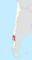
Región de los Lagos
| Los Lagos Region X
Región de los Lagos |
|||
|---|---|---|---|
| Symbols | |||
|
|||
| Basic data | |||
| Country | Chile | ||
| Capital | Puerto Montt | ||
| surface | 48,584.5 km² | ||
| Residents | 828,708 (2017 census) | ||
| density | 17 inhabitants per km² | ||
| ISO 3166-2 | CL-LL | ||
| Website | regiondeloslagos.cl | ||
| politics | |||
| Intendant | Leonardo de la Prida Sanhueza | ||
| Llanquihue Lake and Osorno Volcano | |||
Coordinates: 41 ° 26 ′ S , 72 ° 53 ′ W
Región de los Lagos is a region in southern Chile (Region X).
Geography and administrative structure
The landscape is characterized by many lakes, forests and mountains. The huge island of Chiloe is a very popular tourist destination. The region extends from Osorno to approximately Chaitén in the south.
The region is divided into the four provinces of Osorno , Llanquihue , Chiloé and Palena ; the biggest cities are:
- Capital Puerto Montt 175,000 inhabitants
- Osorno 142,000 inhabitants
- Ancud 40,000 inhabitants
- Castro 39,000 inhabitants
- Puerto Varas 33,000 inhabitants
- Calbuco 31,000 inhabitants
- Purranque 20,949 inhabitants
- Frutillar 15,000 residents
- Chaitén 3,500 inhabitants
history
In 1544 Juan Bautista Pastene explored the area of today's Valdivia on behalf of Pedro de Valdivia. In 1552, Pedro de Valdivia reached Lake Llanquihue . The area was settled by the Mapuche . There were always heavy fights, which the Spaniards often lost. The area south of Valdivia, except for the island of Chiloé, therefore remained uninhabited for a long time by Spaniards, as their cities were repeatedly destroyed by Indian attacks. The island of Chiloé remained Spanish for a long time, even after independence. It could not be conquered until 1826. From 1846, German immigrants settled the area around Lake Llanquihue. They also founded the capital Puerto Montt in 1853. The region later also offered a new home to a large number of Swiss immigrants. In 1960, a large part of the region was hit by a devastating earthquake . In 2007 the province of Valdivia was spun off and raised to its own Región de Los Ríos (XIV. Región).
tourism
Region X is one of the most frequented tourist areas in Chile. The landscape is criss-crossed by lakes and forests. The 866 km² Llanquihue Lake , Lake Rupanco , Lake Todos los Santos , the Osorno volcano , the Puyehue National Park with its hot springs, fishing trips to the streams and rivers and hiking tours in the nearby mountains are among the tourist attractions.
Osorno is a center of German immigrants in the region and has long been a very German-influenced city. Many localities on Lake Llanquihue, especially Puerto Octay and Frutillar , as well as the old manors around Lake Llanquihue, are still dominated by Central Europe .
The port of Puerto Montt is the starting point for trips to Tierra del Fuego and the Strait of Magellan . The island of Chiloé is a popular tourist destination, where the Chiloé National Park in particular in the west of the huge island is often visited.
In the south of the region, around Chaitén, lies the private 2700 km² nature park Pumalin . It was built by the American Douglas Tompkins through large land purchases from the mid-1960s. The land was later given to the non-profit organization Fundación Pumalin . The park is particularly interesting for ecotourism .
economy
The port of Puerto Montt serves as a port of departure for all of southern Chile. Puerto Montt is also the starting point of the huge Carretera Austral highway , which extends far into the south of Chile.
Agriculture plays an important role alongside tourism, especially cattle and dairy farming. Because of the many lakes and coasts, fishing is also an important source of income.


