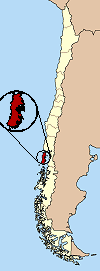
Chiloe
| Isla Grande de Chiloe | |
|---|---|
| Waters | Pacific Ocean |
| Archipelago | Chiloe archipelago |
| Geographical location | 42 ° 36 ′ S , 73 ° 57 ′ W |
| length | 180 km |
| width | 50 km |
| surface | 9 322 km² |
| Highest elevation | Cerro Redondo 866 m |
| Residents | 150,000 16 inhabitants / km² |
| main place | Castro |
| View of the city of Achao | |
Chiloé ( Spanish Isla Grande de Chiloé , German "large island of Chiloé" ) is a Chilean island. It is the second largest island in the country after the main island of Tierra del Fuego , which is half part of Argentina. The main island of the Chiloé archipelago belongs to the Región de los Lagos and forms the province of Chiloé there with several offshore islands .
geography
The island is separated from the mainland by the two kilometer wide Chacao Channel in the north, the 50 km wide Gulf of Ancud in the east and the Gulf of Corcovado in the southeast.
- Length: 180 km (from north to south)
- Width: 50 km
- Area: 9322 km²
- Population: approx. 150,000
The coast of Chiloé is equally high and steep on the east and west side. In the east it is rich in protrusions and natural harbors, in the west it is relatively monotonous and undivided. The Cordillera de Piuchué range of hills in the interior of the island reaches up to 866 m in height.
The inhabitants of Chiloé are known as Chilots , many of whom are descended from the Huilliche people .
Most important cities
- Castro (41,452 inhabitants)
- Ancud (27,292 inhabitants)
- Quellón (13,656 inhabitants)
- Chonchi (4,588 inhabitants)
- Dalcahue (4.933 inhabitants)
- Achao (3,452 inhabitants)
- Queilén (1,912 inhabitants)
climate
The climate is mild but extremely humid; Rain is extremely frequent (there is an annual fall of 2035 mm at Ancud), especially in the western part of the island. The high humidity explains the strong development of the vegetation, which the fertile soil still promotes.
history
Along with Peru, the island is considered one of the possible original homeland of the potato . Around two hundred varieties of potato are still grown there today (e.g. the Michune Azul variety), which differ in shape, color and taste from those known in Europe.
In 1540 Alonso de Camargo explored the island's coastlines from a ship. The island was first set foot on November 8, 1553 by Francisco de Ulloa . In 1559 Juan Fernández Ladrillero entered the island and made contact with the locals. Francisco de Villagra explored the island of Quinchao off Abtao in 1563 . The capital Castro on the east coast was founded on February 12, 1567 by the Spanish captain Martín Ruiz de Gamboa . The first Jesuits arrived on the island in 1608 and built the first church in 1612. In 1628 Vazquez de Espinosa visited the island and reported about the Huilliche cultivation of grain and beans.
In 1788 the capital was moved to Ancud , after which Chacao fell into disrepair. In 1814 the Spanish royalists went to the battle of Rancagua with many soldiers from Chiloé . In January 1826, Chilean troops captured the city of Ancud, which was defended by the Spanish under Coronel Antonio de Quintanilla . In the Treaty of Tantauco , Chiloé fell to Chile. Jose Santiago Aldunate became the new governor of Chiloé. On February 7, 1866, during the Spanish-South American War, a sea battle broke out at Abtao north of the island of Chiloé. In the two-hour battle, however, there was no significant hit on either side.
In 1882 the island had 73,041 inhabitants, mostly indigenous Huilliches. They had long since been subjugated by the Spaniards and converted to Christianity. In 1912 the railway line from Ancud to Castro was built in order to better develop the interior of the island.
On May 22, 1960, many cities on Chiloé were severely damaged by a very severe earthquake measuring 9.5 on the moment-magnitude scale .
economy
The islanders live mainly from tourism, fishing, salmon farming and agriculture.
traffic
The Ferrocarril de Chiloé was a 1912-1960 operated narrow-gauge railway between the cities of Castro and Ancud with a branch to the pier of Lechagua used for goods traffic.
In 2005, the German construction company Hochtief received the order to build the Puente Bicentenario de Chiloé suspension bridge , which should have connected Chiloé with the mainland near Chacao. However, the construction of the bridge was stopped. With a length of 2.6 km it would have become one of the largest suspension bridges in South America as part of the Panamericana highway that already runs through the island.
Culture
Chiloé is known for its mythology, which stems from the Huilliches there and has not been displaced on the island despite strong Catholicism. The best-known legendary figures are the Trauco and the Caleuche , a ghost ship that appears as a beautiful sailing ship with the sounds of a celebration on board, but quickly disappears again or hides by submerging.
tourism
Some of the typical wooden churches on the island and on neighboring, smaller islands were included in the UNESCO World Heritage Church of Chiloé in 2000 . Of these churches are on the main island:
- Castro Municipality : Castro , Rilán , Nercón
- Chonchi Municipality : Chonchi and Vilupuili
- Quemchi municipality : Colo
- Dalcahue Parish : Dalcahue , Tenaún and San Juan
The Chiloé National Park is located in the west of the island.
In 2007 the American magazine "National Geographic Traveler" compiled a ranking of 111 island paradises with the help of a jury of experts (geographers, tourism researchers, etc.). Chiloé reached third place.
Web links
- Chiloé Stories (Engl./span.)
- Entry on the UNESCO World Heritage Center website ( English and French ).


